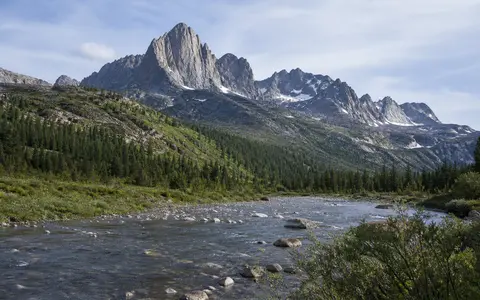
A collective name with two distinct axes
The Great Russian Encyclopedia defines the Sayans as a southern Siberian mountain country consisting of two mountain systems: Western Sayan and Eastern Sayan. This page uses that physical-geography scope. It does not treat the wider South Siberian Mountains, the Altai–Sayan region, the Tuva Republic, or the Yenisei watershed as interchangeable with the Sayans. Nor does it include every mountain north of Mongolia's Khövsgöl basin. (Great Russian Encyclopedia: Sayans)
The Western Sayan lies within Russia, across Krasnoyarsk Krai, Khakassia, and Tuva. It extends for more than 600 km west-southwest to east-northeast, from the Altai and Mountain Shoria toward the Uda Range of the Eastern Sayan. The Tuva and Todzha depressions adjoin it on the south and the Minusinsk Basin on the north. The Eastern Sayan, also principally in Russia, extends more than 1,000 km northwest to southeast from the left bank of the Yenisei to the shores of Lake Baikal. Its southeastern Big Sayan sector reaches the Russia–Mongolia boundary. These are different centerline descriptions, not two parts of one measurable straight line. (Great Russian Encyclopedia: Western Sayan; Great Russian Encyclopedia: Eastern Sayan)
Because the named feature bends across two intersecting systems and has gradual mountain transitions rather than a surveyed perimeter, a single coordinate would imply false precision. The endpoint descriptions and neighboring basins provide more useful orientation than a point marker.
Rounded middle mountains beside alpine massifs
The Western Sayan is not uniformly alpine. Its southwestern ridges rise above 2,800–3,000 m, and Bay-Taiga reaches 3,128 m, the Western Sayan's highest point. Central ridges such as Kurtushibinsky, Mirsky, Aradansky, and Oysky rarely exceed 2,300–2,400 m; farther northeast, the Ergaki and Ergak-Targak-Taiga axes are generally 2,100–2,200 m. Across much of the system, rounded or flattened summits stand above steep, scree-covered slopes and narrow gorge-like valleys. Cirques, U-shaped troughs, moraines, and erratic boulders record Pleistocene glaciers. (Great Russian Encyclopedia: Western Sayan)
The Eastern Sayan changes more strongly along its length. The northwest is dominated by flat-topped middle mountains, many below 2,000 m, whereas southeastward the axial ridges become higher, sharper, and more intensively uplifted. At their southeastern end, the Oka Range, Big Sayan, Tunka Alps, Kropotkin Range, and Kitoy Alps form an arc of high massifs. Mönkh Saridag (Munku-Sardyk), 3,491 m above sea level, in the Big Sayan on the Russia–Mongolia boundary, is the highest summit of both the Eastern Sayan and the collective Sayan Mountains. (Great Russian Encyclopedia: Eastern Sayan)
Relief in both subranges is compartmented rather than ridge-only. The mountain fronts overlook the Tuva, Todzha, Minusinsk, Turan–Uyuk, and Us depressions; smaller valleys and the Oka Depression interrupt the high terrain. This adjacency produces large local contrasts between basin floors, dissected taiga slopes, old plateau surfaces, and alpine headwalls without making the basins themselves mountain ranges.
Old accreted crust, younger uplift, and eastern lava
The Sayans occupy the Altai–Sayan part of the Central Asian accretionary belt, but the two subranges do not share one simple rock history. Much of the Western Sayan is a late Caledonian fold-and-thrust structure assembled during the Silurian from an earlier inter-arc basin and its margins. Its internal zone includes a folded, flysch-like succession—repeated marine sandstones and mudstones—more than 10 km thick, while marginal zones contain remnants of former volcanic arcs and ophiolites, slices of oceanic crust and upper mantle emplaced into the mountain belt. Silurian and Devonian granitoids later intruded these rocks. (Great Russian Encyclopedia: Western Sayan)
The Eastern Sayan adjoins the ancient Siberian Platform and is divided by the Main Sayan Fault. Its northeastern sector includes Archean and early Proterozoic gneiss, amphibolite, and schist, along with younger sedimentary, volcanic, and granitic rocks. The southwestern sector contains Proterozoic basement blocks, late Proterozoic island-arc rocks and ophiolites, and Vendian–Cambrian carbonate rocks assembled mainly by early Ordovician thrusting. These old rock ages describe crustal formation and assembly; they are not the age of the present relief. (Great Russian Encyclopedia: Eastern Sayan)
Long denudation lowered both mountain systems before Cenozoic uplift renewed their relief. In the Eastern Sayan, Neogene uplift was accompanied by basalt eruption. The clearest young volcanic terrain lies around the Oka Plateau: Pleistocene lava in the Jom-Bolok and Sailag valleys forms flows as long as 70 km, with fault-guided valleys, lava-cut canyons, waterfalls, and the Kropotkin and Peretolchin volcanic cones. This eastern volcanic field is a local part of the Sayan record, not evidence that the entire mountain country is volcanic. (Great Russian Encyclopedia: Eastern Sayan)
Fold-and-thrust belt
Marine-basin strata, volcanic-arc rocks, ophiolites, and granitoids were compressed into Paleozoic structure.
Platform-margin collage
Ancient basement and accreted belts meet across the Main Sayan Fault beside the Siberian Platform.
Uplift and basalt
Cenozoic uplift renewed relief; long Pleistocene lava flows occupy a limited southeastern volcanic sector.
All routes lead into the Yenisei basin
The Western Sayan drains entirely to the Yenisei. The Ona, Kantegir, and Amyl descend from the wetter northern slope; the Alash, Systyg-Khem, and Uyuk drain the southern side; and the Us follows the corridor between the Kurtushibinsky and Mirsky ridges. The upper Yenisei cuts north across the range between the Tuva and Minusinsk basins. Snow and rain supply most flow, while winter aufeis—sheet-like ice formed when river or groundwater repeatedly freezes at the surface—stores water that is released during thaw. Northern-slope rivers are generally fuller because they receive deeper snow and more rain. (Great Russian Encyclopedia: Western Sayan)
The Eastern Sayan also lies within the Yenisei basin, but its tributaries take several routes. The Tuba system, including the Kazyr and Kizir, and the Mana and Kan flow toward the Yenisei north of the mountains. The Biryusa and the Uda, Oka, Iya, Belaya, Kitoy, and Irkut belong to the Angara network. They join the Angara or its tributary system downstream from the Angara's outlet from Lake Baikal; the Irkut does not flow first into Lake Baikal. On the southern slopes, the Big Yenisei (Bii-Khem) and its tributaries drain west toward the Yenisei confluence at Kyzyl. (Great Russian Encyclopedia: Eastern Sayan)
Steep headwater gradients produce rapids, falls, and confined channels. In the Eastern Sayan, river ice cover commonly lasts 3.5–5 months; a prolonged snowmelt high-water period is punctuated by sharper rain floods. Cirque lakes and moraine-dammed lakes occupy glacial hollows, while thermokarst lakes form where ice-rich frozen ground subsides. Those water bodies are processes within the range, not evidence of a separate internal-drainage basin.
Continental cold sharpened by slope exposure
Distance from the oceans gives the Sayans long cold winters and short summers, but topography controls where moisture falls. In the Western Sayan, the axial zone receives about 1,200–1,500 mm of precipitation per year; the northern slope generally receives 800–1,000 mm, while the southern slope receives no more than about 500 mm and the Us depression about 330 mm. The wettest month is July and the driest is February. At Olenya Rechka, at 1,000–1,400 m elevation, the mean January temperature is −19.5 °C; the Turan basin's January mean is −34.9 °C, illustrating cold-air pooling rather than a range-wide temperature. (Great Russian Encyclopedia: Western Sayan)
The Eastern Sayan likewise has a wetter west and southwest and a drier east and southeast. The encyclopedia gives 800–1,200 mm or more annually on exposed western and southwestern slopes but only about 300 mm on sheltered eastern and southeastern slopes. Measurements on one glacier at 52.5° N, 98.8° E during 131 summer days in 2015–2017 found that 70% of measured precipitation arrived with western-source trajectories; about 25% came from the southeast during fewer, often stronger events. That short high-altitude record explains a transport mechanism but does not define annual precipitation for the whole 1,000-km Eastern Sayan. (Osipov and Osipova, 2020)
Snow accumulation, slope aspect, and elevation determine where frozen ground and ice persist. In the southeastern Eastern Sayan, continuous permafrost is reported above roughly 1,500–2,000 m, with an estimated thickness of 300–600 m; it becomes discontinuous or isolated lower down. Freeze–thaw weathering produces block fields, patterned ground, solifluction lobes, frost mounds, and thermokarst depressions. These active periglacial processes help widen slopes and rearrange sediment even where modern glacier ice is absent. (Great Russian Encyclopedia: Eastern Sayan)
Extensive former ice, small modern glaciers
Pleistocene glaciers cut cirques and trough valleys and left moraine ridges across high parts of both subranges. Modern glaciers are much more restricted and are concentrated in the high Eastern Sayan massifs. A satellite-and-field inventory mapped 13 glaciers with 5.15 km² of debris-free area across the Peak Topografov and Mönkh Saridag massifs in 2006/2011 imagery: 10 around Peak Topografov and three around Mönkh Saridag. Nine were smaller than 0.5 km² and nine were shorter than 1 km; only one exceeded 2 km in length. This is a two-massif measurement, not a total for the entire Sayan mountain country. (Osipov and Osipova, 2014)
Using moraine limits to reconstruct the Little Ice Age maximum, the same study estimated a 45% loss of debris-free area at Peak Topografov and 53% at Mönkh Saridag between about 1850 and 2006/2011. The authors caution that the reconstructed maximum is not absolutely dated at every glacier; it is based on moraine morphology and regional lichen-size evidence. Published whole-Eastern-Sayan glacier totals use incompatible object counts and areas whose boundary rules cannot be reconciled from the summaries, so this page does not promote one as a timeless range statistic. (Great Russian Encyclopedia: Eastern Sayan; Osipov and others, 2017)
Between Altai, Tuva, and Baikal
At the west-southwestern end of the Western Sayan, the mountain system meets the Altai Mountains and Mountain Shoria. The Minusinsk Basin and southern margin of the Central Siberian Plateau lie to the north; the Tuva and Todzha depressions lie to the south. The two Sayan systems meet around the Ergak-Targak-Taiga and Uda ranges, after which the Eastern Sayan trends toward the faulted Tunka depression and the southwestern shore region of Lake Baikal.
This geometry explains why “the Sayan Mountains” cannot be reduced to a single watershed divide. The Western Sayan separates basin-facing slopes while the Yenisei crosses it; the Eastern Sayan distributes water among direct Yenisei tributaries, the Angara network, and the Big Yenisei headwaters. Use the Mountain Hub to compare this intersecting mountain country with more linear ranges.
Data sources and publications
- Great Russian Encyclopedia. Sayans. Print volume 29, Moscow, 2015, p. 498; accessed 30 August 2026. Accepted collective scope comprising the Western and Eastern Sayan.
- Great Russian Encyclopedia. Western Sayan, accessed 30 August 2026. Extent and boundaries, relief and summit elevations, geology, climate stations and precipitation, glacial landforms, and Yenisei drainage.
- Samoilova, G. S., Khoroshev, A. V., Khain, E. V., and Fedotova, A. A. Great Russian Encyclopedia. Eastern Sayan, electronic edition, 2020; accessed 30 August 2026. Extent, relief, Mönkh Saridag elevation, geology and volcanic terrain, climate, permafrost, and river network.
- Osipov, E. Y., and Osipova, O. P. Mountain glaciers of southeast Siberia: current state and changes since the Little Ice Age. Annals of Glaciology 55(66), 2014, pp. 167–176. Two-massif East Sayan inventory, image years, glacier dimensions, moraine-based reconstruction, and change estimates.
- Osipov, E. Y., Osipova, O. P., and Klevtsov, E. V. Inventory of glaciers in the Eastern Sayan on the basis of space surveys. Ice and Snow 57(4), 2017, pp. 483–497. Landsat/SRTM inventory methods and the whole-range count-area pair deliberately kept separate from other published totals.
- Osipov, E. Y., and Osipova, O. P. Moisture sources and synoptic conditions of summer precipitation in the glacial zone of the East Sayan Range. Advances in Science and Research 17, 2020, pp. 1–8. Glacier-site coordinates, 2015–2017 observation period, and atmospheric moisture pathways.