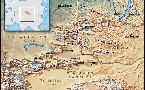

A range system, not a political region
Altai Mountains is the accepted English name; Altay is a common transliteration. Regional forms include Russian Altay, Mongolian Altayn Nuruu, and Chinese Altai Shan. This page uses the broad physical-geography convention: the connected highlands from the Russian and Kazakh Altai through the Chinese and Mongolian Altai toward the Gobi margin. An Asia-Pacific Network report gives that system a rounded length of about 2,000 km. The natural foothill edge is gradual and definitions differ, so this is not an exact polygon or legal area. (Demberel and others, 2019, pp. 10–11)
A recent transboundary study mapped an Altai study window of approximately 43.25°–52.30° N, 81.93°–100.79° E; those coordinates describe that study's working boundary, not a unique range limit or centroid. The Gobi Altai illustrates the scope problem: physiographic accounts may describe it as the southeastern continuation, whereas active-tectonic studies treat it as distinct because its principal strike-slip sense differs from the main Altai. (Tao and others, 2026; Nissen and others, 2007)
A wedge between plains and enclosed basins
The main Altai trends northwest and broadens toward Russia and Kazakhstan. The West Siberian Plain lies beyond its northwestern front, the Junggar Basin borders it to the south, and the Great Lakes Depression lies to the east. The Sayan Mountains continue the highland pattern northeastward, while the Gobi Altai extends away to the southeast under the broader physiographic definition. This arrangement places humid mountain slopes and glaciated knots close to dry steppe and desert-basin floors. (Nissen and others, 2007)
Relief is distributed among separate ranges rather than one crest. The Katun, North Chuya, and South Chuya ranges hold high alpine terrain in the Russian Altai; Tavan Bogd is the major summit knot at the China–Mongolia–Russia junction. Belukha's published elevation is 4,506 m above sea level. A 2001 ice-core site on the saddle between Belukha's two summits was surveyed at 49°48′26.3″ N, 86°34′42.8″ E and 4,062 m; that precise coordinate and height describe the drilling site, not the summit. (Demberel and others, 2019; Olivier and others, 2003)
Ancient crust, young relief
The rocks and the present mountains are not the same age. Much of the basement belongs to the Central Asian Orogenic Belt, assembled during Paleozoic accretion as fragments of continental crust, volcanic arcs, sediments, and intrusive rocks were added around the Siberian craton. Erosion later reduced much of that relief. In the Chinese Altai, modern seismic imaging and earlier thermochronology indicate that the present topography was renewed mainly from about 7 million years ago, when inherited weak zones focused deformation within the continental interior. (Yang and others, 2024)
Across the main Altai, branching northwest-striking right-lateral faults—faults on which the opposite side moves to the right—follow this inherited structural grain. Compression is accommodated partly at bends and ends of those faults, raising blocks beside subsiding or inverted basins. The Mw 7.2 Chuya earthquake of 27 September 2003 ruptured a previously unrecognized strike-slip fault in the northwestern interior of the range. Active faulting is therefore an ongoing landscape process, not only a record preserved in ancient rocks. (Nissen and others, 2007)
Paleozoic collage
Arc, sedimentary, metamorphic, and intrusive units record the assembly of continental crust.
Inherited fault grain
Many active faults reuse northwest-trending zones established by older tectonic events.
Ranges beside basins
Strike-slip motion and local compression raise massifs and organize intermontane depressions.
Dated glacier area and a larger glacial legacy
Glaciers cluster around the highest massifs, including Belukha and the Chuya and Tavan Bogd groups. A methodologically consistent Landsat inventory for the Altai subregion mapped 2,446 glaciers with 1,163 ± 102 km² of planimetric area. The imagery spans 1999–2013 and represents a nominal circa-2010 epoch; it is not a present-day area or ice-volume estimate. Snow obscuration was the largest source of mapping uncertainty. (Earl and Gardner, 2016)
Change measurements must be kept at their study scale. In the North and South Chuya ranges, 126 glaciers that were at least 0.5 km² in 1952 declined from 284 ± 15.6 km² to 228 ± 4.6 km² in 2004—a 19.7 ± 5.8% reduction. This comparison does not describe every Altai glacier. Beyond the modern ice, cirques, U-shaped troughs, moraines, outwash, and ice-dammed-lake deposits record much larger Pleistocene glacier systems. Dated Mongolian Altai records show that glacier extent and lake level responded to both temperature and effective moisture, so a moraine belt cannot be read as a temperature record alone. (Shahgedanova and others, 2010; Klinge and others, 2021)
Arctic headwaters beside endorheic lakes
On the northern side, the Katun and Biya leave the mountains and meet to form the Ob, which crosses western Siberia to the Kara Sea. At Barnaul, the unregulated upper Ob has a two-part spring–summer flood: lowland snowmelt produces the first rise and mountain snowmelt the second, usually larger June rise. Western and southern Altai headwaters also enter the Irtysh, the Ob's largest tributary. “Source of the Ob and Irtysh” therefore describes a network of headwater catchments, not two rivers issuing from one point. (Yermolaeva and others, 2023; UNESCO World Heritage Centre)
East of the principal divides, drainage is endorheic: it ends inland rather than reaching an ocean. The Khovd Gol drains the northwestern Mongolian Altai toward the Valley of Great Lakes, including the connected Khar Us Nuur–Khar Nuur system, while other short catchments terminate in separate lakes or dry basins. Runoff and sediment spread across fans where confined mountain valleys open onto these lower depressions. The contrast between the Ob–Irtysh network and the Great Lakes basins is the range's clearest continental drainage divide. (Klinge and others, 2021)
Westerlies, the Siberian High, and rain shadows
The Altai lie deep inside Eurasia, so annual temperature ranges are large. In the warmer season, westerly circulation carries most available moisture toward the mountains; uplift increases precipitation on exposed western and northwestern slopes. In winter, the Siberian high-pressure system favors cold, dry conditions and little snowfall. The Russian and western Altai are therefore generally wetter, while leeward valleys and the Mongolian interior are much drier. (Klinge and others, 2021)
Observations from 15 stations for 1970–2015 found significant warming throughout the sampled Altai, with subregional mean trends of 0.38–0.45°C per decade. Precipitation behavior was less uniform: annual trends for the three subregions were positive but not statistically significant, and station seasonality differed. That evidence supports a strong northwest-to-southeast moisture gradient, but not a single precipitation trend for the whole range. (Li and others, 2020)
Data sources and publications
- Demberel, O., Hiromichi, F., Borodavko, P. S., Malygina, N., and collaborators. Climatogenic Transformation of the Alpine Landscapes in Mongolian and Russian Altai. Asia-Pacific Network for Global Change Research final technical report CRRP2017-05MY-Demberel (project 2017–2019; accessed 30 August 2026). Broad range name, country span, rounded 2,000 km extent, and regional relief and climate setting.
- Tao, X., Liu, X., Cui, S., Guo, S., and Li, C. “The effects of human activity and snow cover on the distribution of mammals and terrestrial birds in the Altai Mountains under climate change,” Communications Biology 9, 555 (2026). Coordinates and area of the authors' transboundary study polygon; used here only as a map window, not a natural boundary.
- Olivier, S. and others. “Glaciochemical investigation of an ice core from Belukha glacier, Siberian Altai,” Geophysical Research Letters 30 (2003). Belukha's 4,506 m published elevation and the separately surveyed 2001 ice-core site.
- Nissen, E. and others. “Combining InSAR and seismology to study the 2003 Siberian Altai earthquakes—dextral strike-slip and anticlockwise rotations in the northern India–Eurasia collision zone,” Geophysical Journal International 169 (2007), 216–232. Range orientation, neighboring basins, Gobi Altai distinction, inherited faults, and the 2003 earthquake.
- Yang, Y. and others. “Impact of Ancient Tectonics on Intracontinental Deformation Partitioning: Insights From Crustal Structures of the East Junggar–Altai Area,” Journal of Geophysical Research: Solid Earth 129 (2024). Paleozoic crustal inheritance, East Junggar underthrusting, weak zones, and renewed Chinese Altai uplift.
- Earl, L., and Gardner, A. “A satellite-derived glacier inventory for North Asia,” Annals of Glaciology 57(71) (2016), 50–60. Altai subregion's 2,446 glaciers and 1,163 ± 102 km² planimetric area from Landsat imagery dated 1999–2013.
- Shahgedanova, M., Nosenko, G., Khromova, T., and Muraveyev, A. “Glacier shrinkage and climatic change in the Russian Altai from the mid-20th century,” Journal of Geophysical Research: Atmospheres 115, D16107 (2010). Defined-sample glacier-area change in the North and South Chuya ranges, 1952–2004.
- Klinge, M. and others. “Late Pleistocene lake level, glaciation and climate change in the Mongolian Altai deduced from sedimentological and palynological archives,” Quaternary Research 99 (2021), 168–189. Mongolian Altai scope, Khovd drainage, endorheic basins, circulation controls, and glacial–lake history.
- Yermolaeva, N. I. and others. “Zooplankton as an indicator of hydrological connectivity of the main channel and the floodplain in a large river system,” Hydrobiologia 851 (2024). Formation of the Ob at the Biya–Katun confluence and the measured seasonal flood regime at Barnaul.
- Li, Y., Zhang, D., Andreeva, M., Li, Y., Fan, L., and Tang, M. “Temporal-spatial variability of modern climate in the Altai Mountains during 1970–2015,” PLOS ONE 15(3), e0230196 (2020). Fifteen-station temperature and precipitation trends, climate seasonality, and spatial gradients.
- UNESCO World Heritage Centre. Golden Mountains of Altai, World Heritage List no. 768 (accessed 30 August 2026). Ob and Irtysh source-region context and the three-part, 1,611,457 ha World Heritage property.