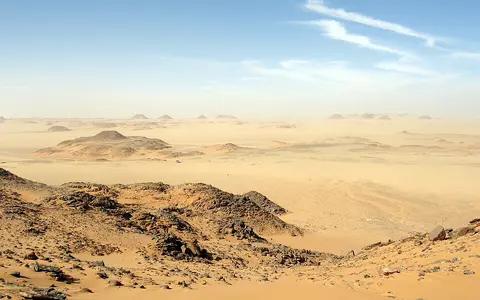

Libyan Desert, Eastern Sahara, and Western Desert
This page uses Libyan Desert in the broad physical-geographic sense found in eastern-Sahara research: the dry interior spanning parts of Egypt, Libya, and Sudan.[1] The term describes a region rather than “the desert portion of Libya.” The national frontiers cross continuous plateaus, sand fields, groundwater basins, and former drainage systems rather than defining their edges.
Usage is not uniform. In Egypt, Western Desert conventionally means the territory west of the Nile, from the Mediterranean to Sudan. One published physical-geography scheme calls its northern, limestone-dominated part the Libyan Desert and its southern sandstone part the Nubian Desert.[2] Other research applies Libyan Desert to the wider eastern Sahara.[1] Because these are different scopes, this record does not attach the frequently repeated but methodologically unclear regional area estimate to its stat cards.
The Nile Valley gives the clearest eastern reference line, but it is not part of the desert's internal drainage. Northward, the hyperarid interior grades toward the Mediterranean coastal belt; westward it merges into other Saharan basins and plateaus. The page includes the Great Sand Sea, Qattara and the Egyptian oasis depressions, the Kufrah sector of southeastern Libya, Gilf Kebir, Jebel Uweinat, and adjoining northwestern Sudan as named components or anchors—not as a closed polygon.
Depressions north, high ground south
The Egyptian part is broadly a sedimentary plateau interrupted by escarpment-bounded depressions. Bahariya, Farafra, Dakhla, and Kharga form a north–south chain east of the Great Sand Sea; Siwa and Qattara lie farther north. The plateau's rock character changes with latitude: northern sectors are dominated by Paleogene limestone, while sandstone is more extensive toward the southern Western Desert.[2][6]
Qattara is not merely a low dune hollow. Egypt's 2003 UNESCO submission describes a closed basin cut into northward-dipping Eocene and Miocene rocks, bounded by steep northern and western scarps. It gives an area range of 18,130–19,500 km² and a lowest point 134 m below sea level; because the submission does not explain the difference between the two mapped areas, the range is retained rather than collapsed to one number.[4] Sabkhas—salt-encrusted flats where shallow saline groundwater evaporates—occupy parts of its floor.
Relief reverses toward the three-country borderlands. Satellite topography used in a rainfall study places the approximately 1,000 m Gilf Kebir plateau near 23.5°N, 25.8°E and Jebel Uweinat, the highest of a local cluster of massifs, near 21.9°N, 25.0°E at about 1,900 m. Uweinat rises roughly 1,000 m above the surrounding desert, while Gilf Kebir rises about 300 m above its plains.[5] These are feature locations and approximate elevations, not a coordinate or elevation for the whole desert.
Qattara Depression
A deep endorheic basin—one with no outlet to the ocean—containing scarps, sabkhas, dunes, and groundwater discharge zones.
Great Sand Sea
A major erg, or sand sea, extending from the Siwa sector south toward Gilf Kebir and straddling the Egypt–Libya frontier.
Gilf Kebir and Uweinat
A dissected plateau and a rugged massif that stand above lower sand sheets and plains near Egypt, Libya, and Sudan.
The Great Sand Sea is layered, not uniform
The Great Sand Sea occupies more than 100,000 km² of westernmost Egypt and extends at its northwestern edge into Libya. Its underlying surface slopes northward from more than 500 m above sea level in the south to less than 100 m near Siwa.[3] Egypt's UNESCO tentative-list submission describes the sand belt as about 650 km from the Siwa area to Gilf Kebir and roughly 300 km wide from the Libyan frontier toward Farafra.[4] Those are bounding dimensions, not a rectangle whose product should replace the independently mapped sand-sea area.
The long ridges visible at regional scale include draa, megadunes with wavelengths greater than 1 km, as well as smaller dunes superimposed on them. Optically stimulated luminescence work—which estimates when mineral grains were last exposed to light—distinguishes Pleistocene megadune construction from younger Holocene dune activity in the southern sand sea.[7] The ridges therefore preserve more than one wind regime and episode of sediment movement.
Wind also sculpts exposed bedrock. North of Dakhla, a mapped yardang field approximately 100 km east–west by 10 km north–south is cut into Paleocene and Eocene limestone. Yardangs are streamlined ridges carved by wind abrasion and removal of loose material. Their distribution changes with bedrock lithology and sand supply, showing that deflation alone does not produce identical landforms everywhere.[6]
Local runoff over a regional aquifer
The interior has no modern river network comparable with the Nile. When rain falls, runoff is short-lived and basin-specific: it moves through wadis and across fans, infiltrates, evaporates, or ends in depressions. In Qattara, the low floor acts as a groundwater base level for bordering aquifers; seepage and intense evaporation help form saline lakes and sabkhas.[4] The Nile is different: it crosses the eastern edge as an externally supplied river whose water originates in wetter regions far outside the Libyan Desert.
The Nubian Aquifer System beneath much of the wider region crosses Egypt, Libya, Sudan, and Chad, but its footprint is not the boundary of the Libyan Desert. A U.S. Geological Survey synthesis characterizes it as a transboundary, non-renewable groundwater system receiving insignificant modern recharge at regional scale. Isotope measurements include groundwater as old as about one million years in Egypt, and present oases and sabkhas occur where the declining water table inherited from wetter Holocene conditions still approaches or intersects the surface.[9]
“Fossil groundwater” therefore means water recharged mainly under past climates, not underground water that is immobile or unlimited. Springs and wells at Siwa, Bahariya, Farafra, Dakhla, Kharga, Kufrah, and other oases tap different layers and flow paths. Local pumping, leakage, salinity, and recharge conditions must be measured at aquifer or well-field scale rather than inferred from the desert-wide label.[9]
Buried rivers beneath today's dry surface
Dry channels and alluvial fills are evidence that the present drainage pattern is not timeless. Radar and elevation analysis reconstructed the Kufrah Palaeoriver across central and southern Libya with a catchment of about 236,000 km². The study maps a system now largely buried by windblown sand, carrying former flow north toward an inland delta at Al Jaghbub and, during parts of its evolution, through the Sirt Basin toward the Mediterranean.[8] This measured catchment belongs to the former river system; it is not an area estimate for the Libyan Desert or the modern Kufrah oasis.
Across the wider eastern Sahara, dated sediments show repeated shifts between wetter phases, surface stability, and aeolian deposition. A synthesis of 48 optically stimulated luminescence ages alongside radiocarbon evidence found that sand seas in Egypt and Wadi Howar in Sudan record different intervals of dune accumulation, reflecting distinct local environmental histories rather than one synchronous desert-wide sequence.[7]
These findings explain why buried valleys, lake deposits, and alluvial plains coexist with almost absent modern flow. Rivers and lakes created and redistributed sediment during wetter intervals; as conditions dried, exposed deposits became sources for sand sheets, dunes, and wind-eroded surfaces. Modern wind reworks an inherited fluvial and lacustrine landscape rather than building the desert from scratch.
A measured hyperarid core with rare seasonal storms
The driest measured core sits across southwestern Egypt and adjoining Libya and Sudan. NASA's Tropical Rainfall Measuring Mission radar estimated an average annual accumulation of only 1–5 mm during 1998–2012 within 20°–27°N, 22°–32°E. Gauge archives and other gridded products broadly supported that location, although the sparse station network and differences between rainfall datasets remain important uncertainties.[5] The coordinate box is a reproducible climate-study extent, not an official outline of the Libyan Desert.
Rain is scarce but not literally absent. In the same 15-year record, light winter events, spring storms with lightning, summer rainfall mainly south of 23°N, and unreliable autumn storms produced a weak seasonal structure. Autumn storms in the northeastern study area were detected in only six of the fifteen years.[5] This supports “hyperarid” while correcting the misleading idea that the region never receives rain.
Topography creates limited local differences. TRMM estimated 5–10 mm/year around the roughly 1,900 m Uweinat cluster, compared with 1–5 mm/year about 100 km west, north, and east; it detected no comparable enhancement over the lower Gilf Kebir plateau.[5] At the regional scale, persistent subtropical subsidence, distance from dependable moisture, clear skies, and very high evaporative demand prevent these rare storms from establishing through-flowing rivers.
Part of the Sahara, distinct from the Nile basin
The Libyan Desert is a physical province within the wider Sahara Desert, not a substitute for the Sahara as a whole. Its eastern reference line is the Nile River corridor, but the river and its upstream drainage basin are hydrologically external to the desert's closed depressions and local wadis.
The Nubian Desert is treated separately in this atlas, especially for the rocky terrain east of the Nile. Terminology overlaps in the south and west of Egypt, however, because some scientific schemes use “Nubian Desert” for sandstone terrain within Egypt's Western Desert. Named regions, rock provinces, aquifers, and modern national borders therefore need to be stated separately rather than assumed to coincide.
Sources and measurement notes
- Kuper, R., “After 5000 BC: The Libyan desert in transition”, Comptes Rendus Palevol 5, 409–419 (2006). Source for the broad use of “Libyan Desert” for the eastern Sahara of Egypt, Sudan, and Libya, and for its modern hyperarid context.
- Abd El-Ghani, M. M., “Floristics and environmental relations in two extreme desert zones of western Egypt”, Global Ecology and Biogeography 9, 499–516 (2000). Source for the extent of Egypt's Western Desert and the cited physical-geography distinction between northern limestone “Libyan Desert” and southern sandstone “Nubian Desert.”
- Besler, H., “Introduction to the Great Sand Sea”, in The Great Sand Sea in Egypt: Formation, Dynamics and Environmental Change, Developments in Sedimentology 59, 1–3 (Elsevier, 2008). Source for the greater-than-100,000 km² sand-sea area, transboundary position, and south-to-north elevation gradient.
- Egyptian National UNESCO Commission and Egyptian National MAB Committee, “Great Desert Landscapes”, World Heritage tentative-list submission 1812 (submitted 12 June 2003; accessed 29 August 2026). Source for Qattara's reported 18,130–19,500 km² area range, 134 m-below-sea-level low point, geological and groundwater setting, and the Great Sand Sea's approximate 650 × 300 km bounding dimensions. The measurements are the State Party's submission and do not define the wider desert.
- Kelley, O. A., “Where the Least Rainfall Occurs in the Sahara Desert, the TRMM Radar Reveals a Different Pattern of Rainfall Each Season”, Journal of Climate 27, 6919–6939 (2014). Source for the 1998–2012 TRMM method, 20°–27°N by 22°–32°E study box, 1–5 mm/year mean, seasonal detections, and approximate Uweinat and Gilf Kebir positions, relief, and local rainfall contrast.
- Brookes, I. A., “Aeolian erosional lineations in the Libyan Desert, Dakhla Region, Egypt”, Geomorphology 39, 189–209 (2001). Source for the Paleogene limestone setting, the approximately 200 m Dakhla scarp, the mapped 100 × 10 km yardang field, and lithology and sand-supply controls on aeolian erosion.
- Bubenzer, O., Besler, H. & Hilgers, A., “Filling the gap: OSL data expanding 14C chronologies of Late Quaternary environmental change in the Libyan Desert”, Quaternary International 175, 41–52 (2007). Source for the 48-age OSL synthesis, Pleistocene megadunes and Holocene dunes in the southern Great Sand Sea, and differing aeolian histories between Egyptian sand seas and Wadi Howar.
- Ghoneim, E., Benedetti, M. & El-Baz, F., “An integrated remote sensing and GIS analysis of the Kufrah Paleoriver, Eastern Sahara”, Geomorphology 139–140, 242–257 (2012). Source for the approximately 236,000 km² former catchment, buried drainage, Al Jaghbub inland delta, and reconstructed connection toward the Sirt Basin and Mediterranean.
- Voss, C. I. & Soliman, S. M., “The transboundary non-renewable Nubian Aquifer System of Chad, Egypt, Libya and Sudan”, Hydrogeology Journal 22, 441–468 (2014), DOI 10.1007/s10040-013-1039-3. U.S. Geological Survey publication record; source for transboundary extent, insignificant regional recharge, Holocene water-table decline, oasis and sabkha relationships, and isotope ages reaching approximately one million years in Egypt.