
A region, not a surveyed parcel
This record uses Nubian Desert for the Sudanese desert east of the Nile, especially the stony interior between the Nile corridor and the Red Sea Hills. A small-scale FAO–UNESCO regional map places it east of the river and partly within the Great Bend; the same account places northern Sudan's broad desert-to-steppe transition near 16°N rather than on a hard boundary.[1] The northern terrain continues across the international border, but Egyptian mapping more often places it within the wider Eastern Desert.
The Sudanese Eastern Desert is also widely called the Atbai. Field researchers distinguish its main Red Sea Hills from the flatter interior nearer the Nile, where Beja names recorded as Awliib or Atmur are used for plains punctuated by inselbergs, dunes, and rocky plateaus.[2] These terms reveal overlapping physical and cultural geographies; none supplies a reproducible perimeter for the whole Nubian Desert.
For that reason this page does not repeat a single total-area figure. Watershed areas, administrative areas, and the extent of the broader Eastern Desert answer different questions and should not be relabelled as the area of the Nubian Desert.
Plains interrupted by scarps and rock islands
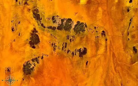
Rock and gravel are more characteristic than continuous dune cover. The 2000 FAO border survey described a 125-km traverse from Wadi Diib west to Sudet as low hills, flat gravel and sandy plains, large and small wadis, and isolated peaks. Jebel Ankur reached 1,480 m and Jebel Sakakamot 1,211 m on the survey's maps; west of Sudet, barren rocky hills and the table-topped Jebel Sudet replace the more open plain.[3]
This measured northern sector should not be treated as a cross-section of every latitude. Near the Red Sea Hills, resistant crystalline massifs, shear zones, and fault-guided valleys create tighter relief. Farther toward the Nile, erosion has left lower sandstone benches, gravel pavements, sand sheets, and inselbergs—isolated hills rising abruptly from an eroded plain.[2][6]
Gravel and sandy plains
Broad low-relief surfaces carry scattered dunes and wadi alluvium rather than an unbroken sand sea.
Mesas and inselbergs
Table-topped residual hills and isolated crystalline outcrops stand above stripped or sediment-covered plains.
Red Sea Hills
More rugged shield rocks form the main topographic and drainage divide before the coastal plain.
Sandstone cover over an older crystalline foundation
The desert is not one sandstone plateau. Regional geological mapping shows Nubian sandstone cover alongside exposed Precambrian basement, younger intrusive complexes, and unconsolidated wadi and wind-blown deposits.[1][6] The crystalline rocks belong to the Nubian side of the Arabian–Nubian Shield and become especially prominent toward the Red Sea Hills.
“Nubian Sandstone” is itself an old umbrella term. A stratigraphic review of its type region in Egypt and Sudan separated the former unit into more than 20 formations ranging from Cambrian to Paleocene age, deposited in changing continental and shallow-marine settings.[7] It is therefore safer to describe a mapped sandstone unit or local plateau than to assign one age and origin to every sandstone exposure.
The eastern relief records a much older tectonic foundation and later rifting. In NASA's Hamisana scene, about 240 km west of the Red Sea, granites and syenites were emplaced during closure of the Mozambique Ocean between about 750 and 610 million years ago; one exposed ring complex is dated to about 624 million years. The same source dates the opening of the main Red Sea section to about 20 million years ago.[8] These ages describe specific rocks and events near the desert's eastern side, not the age of the desert surface as a whole.
Rare floods follow inherited valleys
There is no perennial, locally fed river network across the desert, but several large wadi systems are integrated. Wadi Gabgaba trends north from Sudan and joins the Wadi Allaqi system, which drains northwest from the Red Sea Hills into Lake Nasser. Before the Aswan High Dam impounded the Nile, these channels led to the Nile Valley; today their lower outlet is the reservoir. A 2020 ASTER digital-elevation-model study delineated Wadi Gabgaba at 44,321 km² and Wadi Allaqi at 30,179 km².[5]
An Eastern Nile Technical Regional Office baseline instead mapped the combined watershed at 85,380 km², 72% in Sudan and 28% in Egypt.[4] The reports do not reconcile the 10,880-km² difference; differing watershed boundaries and delineation methods are the likely explanation, not a measured change in the land. Both figures describe drainage basins, not the Nubian Desert's area.
Drainage is not uniformly westward. Wadi Diib follows the western side of the northern Red Sea Hills for about 300 km into Egypt, where its lower course approaches the coastal system; other short catchments descend directly east to the Red Sea.[3] Between storms, channels are dry. When rain does fall, concentrated flow moves gravel and sand, reworks channel floors, and briefly supports vegetation in wadis while much of the adjoining plain remains bare.
Hyperarid interior, wetter mountain pockets
Subtropical subsidence and the desert's continental interior position suppress widespread rain. The result is not one uniform annual average: rainfall varies strongly with latitude, elevation, exposure, and individual storms. In the northern Allaqi–Gabgaba study area, the baseline map increases from effectively 0 mm a year on western Wadi Gabgaba to about 45 mm a year on Red Sea Hills summits, while noting that some years pass without rain.[4]
The hills force moist air upward and receive more dependable local rainfall than the inner plains. This orographic effect—cooling caused by air rising over relief—helps explain why water sources and denser wadi vegetation cluster near the main range, while the lower Atmur or Awliib interior is markedly more barren.[2] Short, intense rain can therefore generate runoff even where a long-term average is very low; a dry channel is evidence of episodic flow, not proof that runoff never occurs.
Desert, sandstone, and aquifer are different extents
Water can occur in fractured crystalline rock, permeable sandstone, and wadi alluvium, but a local borehole observation should not be generalized across the region. The Allaqi–Gabgaba baseline describes groundwater along a fault-zone contact between basement rocks and sandstone, commonly about 30 m below the studied wadi floors and of variable quality.[4]
The Nubian Sandstone Aquifer System is not another name for the Nubian Desert. The IAEA maps that groundwater system across Chad, Egypt, Libya, and Sudan—far beyond this desert.[9] Sharing “Nubian” in the name does not make the desert boundary, sandstone outcrop boundary, and subsurface aquifer boundary coincide.
A Nile–desert–mountain transect
The Nubian Desert belongs to the wider Sahara, but its most useful geographic frame runs west to east. The exogenous Nile—a river sustained by wetter basins outside the desert—cuts a permanent corridor along the western side. Gravel plains, sandstone remnants, and large dry valleys occupy the interior; the crystalline Red Sea Hills then rise toward a narrow coastal plain.
North–south changes matter as well. Transboundary wadis connect northern Sudan to southern Egypt, while the southern desert grades toward steppe rather than ending on a single contour or administrative line. Reading both directions explains why one label includes hyperarid inner plains, mountain catchments with localized rain, and channels whose rare floods can cross an international border.
Sources and measurement notes
- FAO & UNESCO, Soil Map of the World, 1:5,000,000, Volume VI: Africa (1977), especially the geomorphological and geological regional maps and explanatory text. Source for the east-of-Nile/Great Bend placement, approximate 16°N transition to steppe at this map scale, broad surface regions, and Nubian Shield–sandstone relationship.
- Cooper, J. & Vanhulle, D., “Rock Art Surveys in the Sudanese Eastern Desert: Results of the 2018–2019 Atbai Survey Project”, Journal of Egyptian Archaeology 109 (2023). Source for Atbai usage, the Red Sea Hills/interior contrast, Beja names Awliib and Atmur, interior landforms, orographic rainfall, and evidence for a wetter past.
- Cressman, K. & Joint Survey Team, FAO, The First Joint Survey of the Desert Locust Winter Breeding Areas on the Egyptian-Sudanese Border, 26 February–8 March 2000 (Rome, 2000), Appendix 5. Source for the 125-km Wadi Diib–Sudet field transect, Jebel Ankur and Jebel Sakakamot elevations, named wadis, Wadi Diib's approximately 300-km course, and observed gravel, sand, hill, and channel surfaces.
- Eastern Nile Technical Regional Office, Wadi Allaqi–Gabgaba Baseline Studies, in Annex 4: Project Reports (accessed 29 August 2026). Source for the 85,380-km² combined watershed and 28% Egypt/72% Sudan division, gentle wadi floors, local groundwater observation, and the mapped west-to-east rainfall gradient from 0 to 45 mm/year. These figures describe the study watershed, not the desert.
- Hamdan, A. M., “Hydro-Morphometric Analysis using Geospatial Technology: A Case Study of Wadi Gabgaba and Wadi Allaqi Watersheds, Southern Egypt–Northern Sudan”, Journal of Asian Scientific Research 10(3), 190–212 (2020). Source for the ASTER DEM method, flow directions, and separately delineated basin areas of 44,321 km² and 30,179 km².
- Setlow, L. W., U.S. Geological Survey, Geologic Assessment of the Fossil Energy and Geothermal Potential of the Sudan, Open-File Report 83-356 (1983). Source for the generalized geologic map and the regional juxtaposition of basement, Nubian sandstone, intrusive complexes, and younger surface deposits.
- Klitzsch, E. & Wycisk, P., “Paleogeographical development and correlation of Continental Strata (former Nubian Sandstone) in northeast Africa”, Journal of African Earth Sciences 10(1–2), 199–213 (1990). Source for subdivision of the former Nubian Sandstone into more than 20 formations, their Cambrian–Paleocene age range, and varied depositional settings.
- NASA Johnson Space Center Earth Science and Remote Sensing Unit, “The Red Sea Hills of Sudan” (12 November 2023). Source for the Hamisana scene's location and relief, intrusive-rock identification, 750–610 Ma emplacement interval, approximately 624 Ma ring complex, and approximately 20 Ma opening of the main Red Sea section.
- International Atomic Energy Agency, Connecting the Dots: Linking Technical Cooperation Projects on Transboundary Groundwater Resources in Africa (2013). Source for the Nubian Sandstone Aquifer System's four-country extent and the distinction between the aquifer system and the desert.