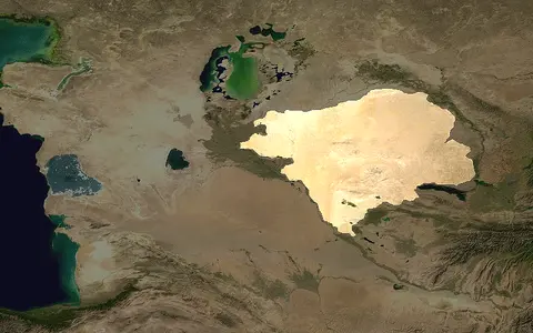

One physical desert, several spellings and margins
This atlas keeps Kyzylkum, its existing English-language spelling in the title and URL. National mapping uses Qizilqum in Uzbekistan and Qyzylqum in Kazakhstan; the Kazakh factfile also records the Russian form Peski Kyzylkum.[1][2] The name is commonly interpreted as “red sand,” but it names the whole physical desert, including rock, clay, and saline ground—not a single continuous sand sea.[3]
This page covers that named desert between the two river corridors. It does not equate the Kyzylkum with the larger Turan Lowland, the entire Aral Sea watershed, the Kyzylkum geological segment of the western Tien Shan, or the newer Aralkum exposed on the former lake bed. The Uzbek and Kazakh toponymic factfiles describe an international Uzbek–Kazakh feature, while a 2024 sediment-provenance paper includes a small Turkmen portion.[1][2][3] That difference reflects gradual natural margins and mapping practice; the sources do not support exact country shares.
A northwest-sloping plain interrupted by old uplands
The broad surface descends from roughly 300 m in the southeast toward about 53 m in the northwest, close to the Aral lowlands.[3] The Amu Darya follows the southwestern side; the Syr Darya runs along the northeastern side toward the Aral basin. East and southeast, the plain approaches the Nuratau and other western Tien Shan–Pamir-Alay foothills. Northward it grades into lower Syr Darya and Aral-margin terrain rather than ending at a surveyed line.
Bukantau and Tamdytau are isolated rocky massifs within the sandy lowland; the Nuratau Range forms a stronger southeastern relief transition. Between and around them lie sandy plains, gravelly or clay-rich surfaces, and enclosed depressions. This arrangement leaves the interior without a through-going natural river network: local runoff ends on fans, in permeable sand, or in internal lows.[3]
Syr Darya corridor
Tien Shan and Fergana sediment reaches the desert along the river's middle and lower course.
Massifs and closed lows
Exposed bedrock breaks the low plain; water and fine sediment collect in depressions without outlets.
Amu Darya corridor
Pamir-derived alluvium is a strong sand source in the northwest, but much less important in sampled southeastern sand.
Linear ridges, barchans, takyrs, and saline hollows
Sand sheets and ridges occupy large tracts, but their form and activity vary. The regional overview in a 2024 study reports common ridges and barchans about 3–30 m high, with local forms up to 75 m.[3] A separate remote-sensing study measured vegetated linear dunes mostly 15–50 m high across the Kyzylkum–Karakum survey region and mapped compound forms in which smaller parabolic dunes cross older, north-northwest–south-southeast linear ridges in eastern Kyzylkum.[4] The ranges describe different mapped dune classes and should not be read as rival estimates of one maximum.
Many large ridges are held by desert plants and biological soil crust rather than migrating freely. Active sand survives as small irregular patches, with the most conspicuous discontinuous field mapped along the southeastern margin.[4] On firmer floors, a takyr is a fine-textured flat that ponds brief runoff and dries into a hard cracked surface. A solonchak is distinguished instead by salt accumulation. Keeping those terms separate avoids treating every bare pale floor as the same landform.
Sand mantles a western Tien Shan basement
Beneath the younger sand and river sediment lies the Kyzylkum segment of the western South Tien Shan. Its basement formed as oceanic and continental fragments were accreted and collided during closure of the Paleozoic Turkestan Ocean. The desert surface also overlaps the northwestern Nuratau segment, while younger continental deposits cover much of the older structure.[3]
Tamdytau exposes this buried framework. Geological work describes deformed and metamorphosed Paleozoic terranes, deep-water clastic rocks, carbonate shelf deposits, and later granitic intrusions, subsequently uplifted and eroded within the reactivated Tien Shan region.[5] Bukantau, Tamdytau, and smaller outcrops are therefore resistant windows through the lowland cover, not dunes cemented into mountains.
Rivers supplied the grains; wind rearranged them
A 2024 study dated detrital zircon grains from four desert-sand samples and six comparison samples from the Amu Darya, Zeravshon basin, and piedmont deposits. Its mixing model identified the southwest Tien Shan as the largest modeled source: 32–42% in the two northwestern desert samples and 46–59% in the two southeastern samples. Fergana Basin sources contributed a modeled 19–23% and 31–37%, respectively; both components were probably delivered mainly by the Syr Darya system.[3]
The Amu Darya signal was geographically uneven—about 34–40% in the northwestern samples beside the river, but only 2–11% in the southeast. Zeravshon material accounted for 5–10% northwest and 12–19% southeast.[3] These percentages are model outputs from a ten-site provenance study, not measured shares for every dune. They nevertheless replace the vague idea of a uniformly local “red” sand with a testable fluvial–aeolian sequence: mountain erosion, river transport and deposition, exposure during channel change, then wind sorting and storage.
The same study found little contribution from the immediately underlying Kyzylkum–Nuratau basement to sampled desert sand and only limited wind homogenization between northwest and southeast. Wind is still essential for making dunes and exporting dust, but it has not erased the river-source pattern.[3]
Marginal rivers, closed interiors, and an engineered lake system
The Amu Darya and Syr Darya belong to the Aral Sea drainage system, but they frame the Kyzylkum rather than gathering a branching network from its centre. Older Syr Darya floodplains and channels crossed northern Kyzylkum before the river reached its late-Holocene position; that longer river history helps explain why Syr Darya–delivered material dominates the sampled sand provenance.[3] Within the present desert, storm runoff is discontinuous and commonly ends by infiltration or evaporation in closed depressions.
The Aydar–Arnasay lakes on the eastern margin illustrate how modern water management can reverse that pattern locally. Uzbekistan's ecology authority reports that the depression formerly held a seasonal salt lake; collector drainage and floodwater began to fill it, and an emergency release from Chardara Reservoir in 1969 established the present lake system.[6] It is therefore a large modern water body within Kyzylkum terrain, but not evidence of an integrated natural desert river or a permanent prehistoric shoreline across the wider desert.
Cold-desert aridity does not mean every dune is active
The regional Köppen class is BWk: an arid desert climate whose annual-temperature regime is cold enough for the “k” qualifier.[4] A regional synthesis places annual precipitation at roughly 100–200 mm, mostly in winter and spring.[3] Across the wider Kyzylkum–Karakum study area, July means exceed 30 °C, January means range from about −10 to 0 °C, and more than half the precipitation falls from December through April; these are regional summaries, not a single station normal for the whole Kyzylkum.[4]
Wind direction changes seasonally: the 2024 provenance study summarizes westerly and southwesterly flow in winter and early spring and stronger northeasterly flow in summer.[3] Yet sand-moving power is generally modest. Analysis of hourly ERA5 winds for 1950–2019 found most Kyzylkum grid cells in a low-energy environment, with values above the study's 200-vector-unit threshold confined to a small part of the northern margin and a predominantly declining trend in annual drift potential.[4]
The orientation of the large ridges therefore records older as well as present wind regimes. Stabilization is not permanent everywhere: disturbance, drought, or loss of vegetation and crust can expose sand, while seasonal winds continue to reshape active patches. The measured pattern is a mosaic of relict, stabilized, and locally mobile surfaces—not a desert steadily migrating in one direction.
The northern sand tract of the Turan Lowland
Within the Desert Hub, the Kyzylkum is best read as a lowland sediment-routing system bounded by major rivers and broken by old rocky uplands. It connects eastward to the western Tien Shan foothills and northwestward to the Aral Sea lowlands, but neither the whole mountain system nor the full terminal basin is part of this page's scope.
Across the Amu Darya, the Karakum Desert is the closest comparison. Both contain stabilized linear dunes, takyrs, and inherited river sediment; their provenance differs, however. Amu Darya sediment is central to Karakum formation, whereas the sampled Kyzylkum sand shows a larger Syr Darya–southwest Tien Shan–Fergana contribution.[3]
Sources and measurement notes
- United Kingdom Permanent Committee on Geographical Names, Uzbekistan: Toponymic Factfile, pp. 1–2, 6 (January 2023; accessed 29 August 2026). Source for Uzbek national mapping policy, the Uzbek form Qizilqum, feature type, two-country attribution, and the 42°43′13″N, 63°58′18″E map reference point.
- United Kingdom Permanent Committee on Geographical Names, Kazakhstan: Toponymic Factfile, p. 6 (September 2022; accessed 29 August 2026). Source for the Kazakh and Russian labels Qyzylqum/Peski Kyzylkum, feature type, two-country attribution, and the same map reference point. Neither factfile defines the point as a centroid.
- Zhang, H. et al., “Provenance and Fluvial–Aeolian Process of Kyzylkum Desert: Constrained by Detrital Zircon U–Pb Dating”, Geophysical Research Letters 51, e2024GL108951 (2024). Source for the rounded area and country extent, 53–300 m regional surface range, relief and dune-height summary, 100–200 mm precipitation range, geological setting, seasonal wind summary, ten-sample method, modeled source contributions, river history, and sediment-routing interpretation. The paper does not supply a digitized desert perimeter, a vertical datum for its regional elevation values, or a measurement method for the summarized 3–30 m and 75 m dune heights.
- Petrović, M. Z., Blumberg, D. G., Orlovsky, L. & Maman, S., “Spatiotemporal analysis of dune stabilization in the Kyzylkum and Karakum sandy deserts”, Frontiers in Earth Science 11, 1129360 (2023). Source for BWk classification, regional seasonal temperature and precipitation timing, dune classes and mapped 15–50 m vegetated-linear-dune heights, Kyzylkum active-patch distribution, and wind-energy trends. Methods combine satellite imagery and DEMs, 36 NOAA stations for 2010–2019, hourly 0.1° ERA5 winds for 1950–2019, and CRU TS 4.05 precipitation for four 30-year periods through 2020; combined-region values are labelled as such in the text.
- Mukhin, P., Mirkamalov, R. & Seltmann, R., “Structure of the Muruntau gold ore region in the Kyzyl-Kum desert (Central Asia)”, International Journal of Earth Sciences 112, 659–683 (2023; version of record published 10 November 2022). Source for the Tamdytau basement exposures, Paleozoic accretion and collision, metasedimentary and carbonate units, granitic intrusion, and later reactivation. Ore-resource claims are outside this page's scope.
- National Committee on Ecology and Climate Change of the Republic of Uzbekistan, “Birdwatching activities were held in the territory of the Aydar–Arnasay lakes” (6 October 2025; accessed 29 August 2026). Used only for the physical location, pre-1950s seasonal salt-lake condition, collector-drainage and reservoir inflow, and 1969 formation history of the modern lake system; tourism and wildlife promotion are not used as physical-geography evidence.