
One desert, several mapped margins
Garagum means “black sand.” It is the Turkmen name of the physical desert; “Karakum Desert” is the established English form.[1] This record covers that named sand-dominated landscape. It does not treat all of Turkmenistan's arid land, the wider Central Asian southern-desert ecoregion, the subterranean Amu Darya sedimentary basin, or the administrative districts named Garagum as equivalent features.
No single surveyed natural boundary underlies the common area claims. A peer-reviewed geomorphological review assigns about 70% of Turkmenistan to the Karakum, the UK toponymic factfile says around 75%, and FAO's 2012 country profile uses 80%.[1][3][6] Because none supplies a shared digitized perimeter, this page reports the range rather than converting one percentage into a falsely exact square-kilometre area.
Between river valley, mountain front, and Caspian lowland
The desert's clearest eastern and northeastern edge is the Amu Darya valley; the Kyzylkum Desert lies beyond the river. To the south, Karakum sands meet the Kopetdag piedmont and the Badghyz–Karabil uplands toward Afghanistan. The lower Amu Darya–Khorezm and Sarygamysh region form the northern transition, while the old Uzboy corridor and Caspian lowlands frame the west. The small Afghan continuation recognized by the UK factfile belongs to the same physical dryland, not to Turkmenistan's administrative territory.[1][3]
The elevated Trans-Unguz or Zaunguz sector lies north of the Unguz depression; lower central Karakum lies to its south, and southeastern Karakum includes the Amu Darya-facing and Murghab-fan terrain. Unguz is a discontinuous belt of depressions, solonchaks (salt-affected flats), dunes, and a scarp-like structural line—not a continuous modern river channel.[3][7] A hydrological study found no fluvial terraces or bed erosion sufficient to confirm the entire Unguz belt as a former Amu Darya course.[7]
Beneath much of central and eastern Turkmenistan is the far larger geological architecture of the Turan Platform and Amu Darya sedimentary basin. That subsurface basin contains thick Paleozoic-to-Cenozoic successions, whereas the Karakum is the surface desert and its comparatively young sand, alluvium, clay, and salt landforms.[3] The two overlap, but their boundaries and meanings are not interchangeable.
Ridges dominate, but the surface is a mosaic
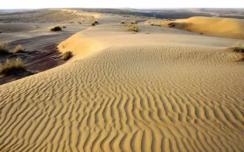
The Karakum is not a continuous field of tall, bare dunes. Vegetated linear dunes are widespread, with barchans, barchanoid ridges, sand sheets, clay-floored interdune lows, and localized active patches superimposed on older forms. A 2023 remote-sensing and wind study mapped 15–50 m vegetated linear dunes across the Karakum–Kyzylkum study region and simple barchans no higher than about 10 m; these are mapped class ranges, not maximum heights for every Karakum dune.[5]
More feature-specific measurements come from southern Karakum, where north–south ridges over the Murghab alluvial fan reach about 30 m of relief and average about 2.5 km apart.[3] Their spacing shows the scale of the ridge-and-corridor topography: the landscape may rise gradually over kilometres rather than as isolated crescent dunes. The distal fan is made of fine river-deposited silt and clay, locally eroded into yardangs—streamlined ridges cut by wind—and partly buried by mobile sand.[3]
Takyrs occupy some interdune and fan depressions. These are hard, fine-textured, low-permeability catchments that shed or briefly pond storm runoff before drying and cracking; a Landsat-and-field study describes individual central Karakum takyrs as about 0.5–3 km².[8] They differ from solonchaks, where near-surface salts are the defining material. At the northwest edge of the desert, Akhchakaya is a separate closed depression southeast of Sarygamysh, reported at about 92 m below sea level.[3] That local low should not be used as the general elevation of the Karakum.
Linear dunes and ridges
Older large forms preserve several wind regimes; vegetation and biological crust stabilize much of their present surface.
Fans and inherited channels
Amu Darya, Murghab, and Tejen sediment supplied surfaces that wind later sorted and reshaped.
Takyrs and solonchaks
Fine sediment and salts collect where short-lived runoff and shallow groundwater end within the desert.
Alluvium first, wind reworking afterward
The desert's sand cannot be explained as locally weathered quartz alone. Petrographic work compared southern Karakum dune samples with sand from the Panj, Vakhsh, and other mountain branches of the Amu Darya. Matching feldspar–lithic–quartz proportions and epidote–amphibole–garnet heavy-mineral suites point back to rocks of the western Pamir, transported west by the river.[4] Near the Caspian side, extra carbonate and felsic volcanic grains show additional recycling from the Kopetdag and Balkan cover rocks.[4]
The resulting sequence is fluvial–aeolian: migrating rivers and inland deltas spread sand, silt, and clay across the lowland; drying exposed those deposits; and wind sorted and rearranged them into sheets and ridges. Some Lower Karakum ridge-and-valley relief may preserve fluvial structure rather than being wholly wind-built, so the page does not assign every ridge a single origin.[3] Repeated Amu Darya course changes explain how Pamir-derived sediment reached areas far west of the modern river.[4]
Present wind does not simply reproduce the large inherited forms. Using ERA5 reanalysis for 1950–2019, checked against 36 NOAA stations for 2010–2019, a 2023 study found low-energy wind conditions across 93% of the combined Karakum–Kyzylkum survey area.[5] Active Karakum patches remain along the Amu Darya and in western and southeastern sectors, but the great majority of mapped compound and complex linear forms are stabilized by vegetation and biological soil crusts.[5]
Rivers reach margins and inland deltas
The Karakum has no integrated natural drainage network crossing its interior to the sea. The Amu Darya flows northwest along the east and northeast margin. The Murghab and Tejen arrive from Afghanistan and the Iranian–Afghan highlands, spread across the Mary and Tejen inland-delta oases, and terminate in the desert; FAO's 2012 water-resources table lists their outflow destination simply as “Desert.”[3][6] Floodwater and seepage may continue into fan sediment and groundwater even after a visible channel ends.
The Uzboy is a 750 km dry channel connecting the Sarygamysh region with the western Karakum and Caspian lowland. It carried water episodically after the last glaciation, including during documented historical intervals, but hydraulic reconstruction shows that it could not convey the whole Amu Darya discharge.[7] Much water instead spread through distributaries and interdune channels or was lost to evaporation and infiltration in Zaunguz. Calling Uzboy a former outlet is therefore accurate; describing it as the river's sole permanent former course is not.
The Karakum Canal is artificial. Beginning at the Amu Darya, it crosses the southern desert through the Murghab and Tejen systems toward the Kopetdag foothills. FAO's 2012 Turkmenistan profile reports about 1,400 km, an estimated capacity of 630 m³/s, and an annual Amu Darya withdrawal of 10–12 km³; the same publication's regional summary rounds the length to 1,300 km.[6] These figures describe the canal as reported in that edition, not natural Karakum runoff.
Cold-desert aridity with a cool-season pulse
A recent dune study assigns the Karakum–Kyzylkum region to the Köppen BWk class: arid desert climate with a cold annual-temperature regime.[5] The Karakum's continental position produces hot, nearly rainless summers and winters cold enough for frost. Moisture arrives mainly from October through April; mountain barriers to the south and southeast enhance contrasts between the dry lowland and wetter uplands.
FAO's 2012 Turkmenistan profile gives country-scale annual precipitation of about 191 mm, from under 80 mm in the northeast to 300 mm in the Kopetdag, with July means above 30 °C and estimated open-water evaporation of 2,000–2,300 mm per year.[6] These are national regional ranges, not a station normal for the whole desert. They nevertheless show why brief cool-season rain can wet takyrs while the annual water balance remains strongly negative.
Wind effectiveness also varies spatially. The 1950–2019 analysis found the most energetic Karakum sectors along the southwestern takyr–solonchak margin, Caspian coast, and southeast, while most of the interior remained low energy.[5] A southern interior barchanoid field received more than 125 mm mean annual precipitation in the study's reanalysis and was fully occupied by vegetation and crust despite retaining large dune relief.[5] Present stability therefore reflects both limited sand-moving wind and enough moisture for surface cover, not an absence of sand.
A Turan Lowland counterpart to the Kyzylkum
Within the Desert Hub, the Karakum is best understood as a lowland sediment-routing system: Pamir and southern-highland rivers supplied detritus, abandoned channels and fans distributed it, and variable winds built and reworked dunes. Across the Amu Darya, the Kyzylkum Desert occupies the other major sand tract of the Turan Lowland, but it is a distinct named feature with different source mixtures and national extent.
The Caspian Sea is the western base-level reference, not the outlet of a modern Karakum river network. The dry Uzboy preserves the closest physical connection, while most present natural drainage is consumed on inland fans or directed along the Amu Darya toward the Aral basin.
Sources and measurement notes
- United Kingdom Permanent Committee on Geographical Names, Turkmenistan: Toponymic Factfile, pp. 9–10 (updated 2025; accessed 29 August 2026). Source for official Turkmen Garagum, English “Karakum Desert,” the meaning “Black Sand,” the around-75% national share, broad northern and southern limits, and the small extension into Afghanistan.
- Getty Research Institute, “Karakum Desert”, Getty Thesaurus of Geographic Names record 1103391 (accessed 29 August 2026). Source for the 39°N, 60°E reference coordinate and recorded name variants. The coordinate is catalog metadata for a region, not a calculated centroid.
- Ghassemi, M. R. & Garzanti, E., “Geology and geomorphology of Turkmenistan: A review”, Geopersia 9(1), 125–140 (2019). Source for the approximately 70% share, Turan Platform setting, average and regional relief, −92 m Akhchakaya value, Unguz structure, southern ridge measurements, Murghab fan and yardangs, and the distinction between surface desert and underlying Amu Darya basin. The article does not identify a vertical datum for the elevation figures.
- Garzanti, E., Ghassemi, M. R., Limonta, M. & Resentini, A., “Provenance of Karakum Desert sand (Turkmenistan): lithic-rich orogenic signature of Central Asian dune fields”, Rivista Italiana di Paleontologia e Stratigrafia 125(1), 77–89 (2019). Source for the petrographic and heavy-mineral comparison, western Pamir–Amu Darya sediment route, western local recycling, and fluvial–aeolian formation model.
- Petrović, M. Z., Blumberg, D. G., Orlovsky, L. & Maman, S., “Spatiotemporal analysis of dune stabilization in the Kyzylkum and Karakum sandy deserts”, Frontiers in Earth Science 11, 1129360 (2023). Source for the BWk classification, mapped dune types and heights, 1950–2019 ERA5 and 2010–2019 NOAA methods, 93% combined-region low-energy result, active-sector pattern, southern Karakum precipitation result, and widespread vegetation-and-crust stabilization. Combined-region statistics are not presented here as Karakum-only values.
- Food and Agriculture Organization of the United Nations, Irrigation in Central Asia in Figures: AQUASTAT Survey—2012, Water Reports 39, Turkmenistan profile pp. 163–174 and regional overview (2013; accessed 29 August 2026). Source for the 80% national share, 2012 climate ranges and evaporation estimate, river destinations, and reported Karakum Canal dimensions and withdrawals. The profile gives 1,400 km while the regional summary gives 1,300 km, so the canal length is treated as rounded.
- Létolle, R., Micklin, P., Aladin, N. & Plotnikov, I., “Uzboy and the Aral regressions: A hydrological approach”, Quaternary International 173–174, 125–136 (2007). Source for the 750 km Uzboy length, episodic postglacial flow, channel-capacity limits, water loss in Zaunguz, and the geomorphic evidence against treating Unguz as a continuous former river course.
- Maman, S., Orlovsky, L., Blumberg, D. G., Berliner, P. & Mamedov, B., “A landcover change study of takyr surfaces in Turkmenistan”, Journal of Arid Environments 75(9), 842–850 (2011). Source for takyrs as fine-textured, low-permeability runoff catchments, the 0.5–3 km² central Karakum size range, and Landsat, QuickBird, GPS, and field-validation methods.