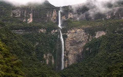
What Yumbilla Falls is
Yumbilla Falls lies in Cuispes District, Bongará Province, in Peru's Amazonas Region. It occupies the eastern, or right-bank, side of the middle Utcubamba corridor in the northern Peruvian Andes. The waterfall begins near 2,723 metres above sea level, where the official Peruvian inventory describes its flow as emerging from San Francisco cave, and reaches lower terrain near 1,828 metres.
The quoted height of 895.4 metres is the difference across the full waterfall system. Four major drops and intervening breaks in slope make Yumbilla a tiered descent, not a single 895-metre plunge. That distinction matters geographically: the falls trace a long, irregular route down a mountain face whose gradient changes from near-vertical sections to ledges and steep connecting channels.
Yumbilla belongs to the same waterfall-rich part of Amazonas as Gocta and Chinata. Each occupies a tributary slope above the Utcubamba, but each has its own headwater geometry, number of drops, and relationship between surface and subsurface drainage.
Four drops across a steep Andean slope
The landform begins on an elevated mountain surface and ends far below on the flank of the Utcubamba valley. Rather than one uniform cliff, the slope is broken into a sequence of steep faces. Each face renews the free fall, while the intervening terrain briefly returns the water to rock contact before the next drop.
This stepped profile distributes erosion along the mountain front. At the bases of the drops, impact, spray, weathering, and sediment movement work on recesses and short gorge sections. On the connecting slopes, channel flow and gravity move loosened material downslope. The result is a waterfall complex embedded in a broader dissected mountainside rather than a single isolated brink.
San Francisco cave
Water appears at the surface high on the massif, showing that subsurface routing contributes to the headwater.
Four major drops
Ledges and steep channel reaches interrupt the total descent and divide it into stages.
Utcubamba valley flank
The stream enters lower terrain within a drainage system that opens toward the regional trunk river.
A steep, elongated mountain drainage
Catchment research places the falls in the Yumbilla–El Chido microbasin, a northwest–southeast-oriented drainage of about 147.2 square kilometres. The mapped basin is roughly 23.5 kilometres long and has an elongated rather than circular outline. It is bounded by the Pomacochas drainage to the north, the Imaza basin to the east, and Utcubamba-side drainages to the west and southwest.
The basin study calculated a mean slope of about 38.7 percent, the highest of the three neighbouring waterfall basins it compared. That value describes the drainage as a whole rather than the near-vertical faces of Yumbilla itself, but it confirms the importance of strong regional relief. Rainwater can move rapidly down these slopes, although forest cover intercepts rainfall and permeable ground promotes infiltration.
The mapped drainage density is relatively low for such steep terrain. Combined with the cave source, this suggests that water movement is not limited to a dense network of surface channels: infiltration, soil-water storage, and subsurface pathways also help connect rainfall on the uplands to flow at the waterfall.
Groundwater emergence with rainfall-driven variation
Yumbilla's headwater emerges from San Francisco cave, making subsurface flow an important part of the waterfall's hydrology. Rain entering the upland catchment can infiltrate permeable ground, move through shallow or deeper pathways, and reappear at the cave before descending the escarpment. This storage and routing distinguish the source from a channel supplied only by immediate overland runoff.
The waterfall nevertheless responds to the seasonal distribution of rain. The wetter part of the year is broadly concentrated from November through April, when the falling columns become fuller and spray expands across the cliff. During the drier months, discharge contracts and wind can disperse the thinner free-falling sections more readily. The presence of a cave source may sustain flow between rain events, but it does not remove the annual contrast.
High-intensity rain has effects beyond water volume. Steep basin slopes accelerate runoff, while forest and infiltrating ground slow part of the response. At the falls, stronger pulses increase turbulence, transport sediment through connecting channels, and concentrate erosive work at the foot of each stage.
Humid eastern-Andean controls across a large elevation range
Yumbilla lies where moist air from the Amazonian lowlands meets rising terrain on the eastern side of the Andes. Uplift cools the air and supports cloud formation and mountain rainfall. A basin study characterized the Yumbilla–El Chido area as semi-humid to slightly humid and warm-temperate, with temperatures broadly between 11 and 19.9 °C and annual precipitation around 1,000 millimetres.
Those basin-wide figures conceal strong vertical contrasts. The source area is cooler and more exposed, while the lower end of the waterfall lies almost 900 metres lower and is generally warmer. Humid montane forest and high-elevation vegetation in the headwater region reflect this transition and influence interception, infiltration, and soil-water retention.
Rainfall seasonality controls the visible form of the falls, but topography controls where that rainfall is produced and how it is delivered. The combination of east-facing mountain uplift, a high source area, permeable ground, and very steep relief explains why Yumbilla can be both cave-fed and strongly responsive to wet-season weather.
From Cuispes to the Amazon basin
After the four-stage descent, Yumbilla's water continues through the lower Yumbilla–El Chido network toward the Utcubamba. The Utcubamba flows north through Amazonas and joins the Marañón, one of the principal rivers forming the upper Amazon system. A waterfall on a mountain tributary is therefore connected to a continental drainage route extending far beyond its immediate cliff.
The local comparison with Gocta Falls is especially useful. Both drain the eastern Andes toward the Utcubamba, but Gocta makes two principal drops from a smaller neighbouring catchment, whereas Yumbilla divides a greater total elevation loss into four stages and begins at a cave outlet.
For broader context, continue to the waterfalls hub, the rivers hub, or the terrain index. Together these records show how groundwater, rainfall, slope breaks, and trunk-river incision combine across the northern Andes.