.jpg)
What Gocta Falls is
Gocta Falls lies in Valera District, Bongará Province, in Peru's Amazonas Region. It is formed within the Cocahuayco River drainage, a relatively small mountain catchment above the middle Utcubamba valley.
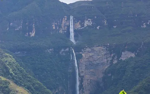
The waterfall is best understood as a stepped transfer of water across exceptional local relief. An upper fall reaches an intervening ledge or steep channel section before the larger lower fall continues toward the valley-side gorge. Because the quoted total height includes both stages, it should not be treated as the height of a single uninterrupted plunge.
Calcareous mountains and an abrupt escarpment
Gocta occupies the eastern flank of the northern Andes, where deeply cut valleys separate high mountain surfaces. Geological mapping places the catchment among Mesozoic sedimentary units, including calcareous rocks, and regional geomorphic work associates the steep local slopes and waterfalls with abrupt, fault-controlled scarps.
That structure supplies the large break in gradient. Resistant rock maintains a steep face while weathering, rockfall, and running water reshape ledges and the lower gorge. Spray and falling water are therefore only part of the system: the waterfall also records the contrast between an upland surface and the entrenched Utcubamba corridor below.
High Andean catchment
Runoff gathers above the brink among grassland, wet ground, and montane slopes.
Two principal drops
A ledge interrupts the long descent and divides it into upper and lower stages.
Utcubamba valley flank
The falling stream enters lower, warmer terrain before joining the trunk valley drainage.
A small rain-fed tributary with seasonal contrast
The Cocahuayco catchment receives water from upland tributaries and wet highland ground. Research in the drainage identifies high-altitude peatlands and jalca vegetation above the cloud-forest belt; these saturated areas store water and help connect rainfall on the upper surface with streamflow at the escarpment.
Flow persists through the year but varies with rainfall. The wetter season generally extends from about November through April, with the strongest rains commonly from January to March. The May-to-October period is drier, especially around June to August, so the width, spray volume, and visual continuity of the falls change through the annual cycle.
Moist eastern-Andean air and elevation
Gocta's water supply reflects its position on the humid eastern side of the Andes. Moist air moving toward rising terrain promotes cloud formation and rainfall, while the large elevation difference across the falls creates sharp local contrasts. The high catchment is cooler and exposed; the lower valley-side terrain is warmer.
Cloud forest on the slopes and jalca at higher elevations mark this vertical climate transition. These zones are geographically relevant because they influence interception, soil moisture, and the timing of runoff, although the waterfall's discharge still responds clearly to wet- and dry-season rainfall.
From Cocahuayco to the Amazon system
Below the falls, the Cocahuayco drainage reaches the Utcubamba River. The Utcubamba flows north through the Amazonas Region and then joins the Marañón, one of the principal headwater rivers of the Amazon. Gocta is therefore part of a much larger eastward-draining network despite occupying a compact local catchment.
This basin connection places the falls within the waterfalls hub and the broader rivers hub. At regional scale, Gocta also belongs to a belt of waterfalls along the steep middle Utcubamba valley margins, where pronounced relief repeatedly brings tributary channels across major breaks in slope.