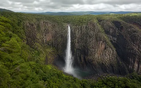
What Wallaman Falls is
Wallaman Falls lies southwest of Ingham in the Wallaman section of Girringun National Park, northeastern Queensland. The waterfall occupies the eastern highlands beside the Herbert River Valley and forms part of the Wet Tropics of Queensland World Heritage Area. Stony Creek approaches across elevated forest country before reaching a sharp break in slope at the head of its lower gorge.
At the brink, the channel narrows and the creek makes a clear vertical plunge of 268 metres. Wind and spray can separate the falling column before the water reaches the gorge floor, especially when discharge is low. Below the main fall, water collects in a plunge pool and continues through a steep, enclosed channel toward the Herbert River.
Geoscience Australia distinguishes the 268-metre main drop from the smaller cascades above and below it. This makes the physical form clearer: Wallaman is principally a high single plunge within a longer stepped creek profile, rather than a uniform 305-metre cliff.
Upland creek, cliff edge, and gorge floor
The waterfall is part of a much larger contrast between the elevated terrain west of the coastal plain and the deeply incised Herbert River system. Above the brink, Stony Creek occupies a comparatively low-gradient upland course with rock pools and short channel steps. Over a very short horizontal distance, that subdued profile gives way to the near-vertical face of the falls.
The receiving gorge is narrow and humid, with a steep headwall and rockfall-prone slopes. Water and falling sediment concentrate energy at the base, while blocks detached from the cliff accumulate around the plunge zone and lower channel. The deep hollow is therefore produced by several linked processes: direct impact and abrasion by the creek, weathering along weaknesses in the rock, and gravity-driven removal from the high walls.
Upland Stony Creek
A permanent stream crosses gentler forested terrain and rock pools before reaching the escarpment.
268-metre bedrock drop
A sharp convex break in the creek profile creates the main open-air plunge.
Plunge pool and tributary gorge
Falling water, sediment, weathering, and rockfall maintain a steep recess below the cliff.
A tributary left above the Herbert River gorge
Wallaman Falls developed within the long-term evolution of Queensland's northeastern continental margin. Crustal movement and erosion established strong relief between inland uplands and the Coral Sea side of the continent. The Herbert River later cut eastward through this terrain, deepening and extending its gorge as the main channel adjusted to a lower base level.
Stony Creek did not cut downward at the same rate as the larger river. As the Herbert gorge retreated into the highlands, tributary valleys were left suspended above the main valley floor. Wallaman Falls marks one of these hanging junctions: the tributary reaches the valley margin at high elevation and must descend abruptly to join the lower drainage system.
The fall is not stationary over geological time. Spray, runoff, and plunge-pool turbulence attack fractured and weathered rock at the head and foot of the drop. Rockfalls enlarge the recess, and the creek carries finer debris away. Together these processes allow the waterfall lip and gorge head to retreat gradually upstream, even though the resistant cliff preserves a steep profile.
Permanent flow with a strong seasonal pulse
Stony Creek gathers surface runoff and shallow subsurface flow from a compact upland catchment. The waterfall is described by Queensland Parks as permanent, but permanent does not mean constant. Discharge expands greatly during the summer wet season, when sustained rain and intense storms feed the creek, and contracts during the generally drier middle and later months of the year.
During high flow, a broader and heavier column reaches the plunge pool and sends spray across the gorge walls. During lower flow, the column narrows, wind disperses more of it into mist, and the creek's rock pools become more prominent relative to the connecting channel. Short flood pulses can also move sediment and woody material through the system, doing a disproportionate share of channel and plunge-zone work.
Below the falls, Stony Creek descends through its gorge as a tributary of the Herbert River. This places the waterfall inside a basin of about 9,900 square kilometres, far larger than the creek's own headwater area. The falls are therefore a local gradient break embedded in a regional drainage network.
Monsoon, trade winds, and mountain uplift
The Wet Tropics has a warm tropical climate with a pronounced wet season from about November to April and a drier season from May to October. Northwesterly monsoon flow, thunderstorms, tropical lows, and occasional cyclones provide much of the annual rainfall. The strongest runoff at Wallaman Falls usually reflects this concentration of rain in the warmer part of the year.
Topography modifies the regional pattern. Moist air is lifted across northeastern Queensland's ranges, cools, and releases orographic rain. Southeasterly trade winds can still deliver precipitation outside the main monsoon period, helping distinguish Wallaman from waterfalls that disappear completely each dry season. Rainfall varies from year to year as tropical circulation and Pacific Ocean conditions change, so the width and force of the fall also vary between wet seasons.
Climate effects continue after water crosses the brink. Persistent mist raises local humidity near the plunge pool, while the enclosed gorge limits direct drying. These conditions influence weathering of the rock face and the retention of moisture on lower slopes, but they remain a local consequence of the waterfall within the broader wet–dry tropical setting.
From the eastern highlands to the Coral Sea
Wallaman Falls occupies a transition from upland terrain into the Herbert River Valley. After leaving the gorge, Stony Creek joins the Herbert system. The Herbert crosses the lower coastal plain around Ingham, passes through a floodplain and wetland landscape, and drains toward Halifax Bay and the Great Barrier Reef lagoon.
This downstream sequence connects three distinct geographic scales: a bedrock lip on one creek, a deeply cut tributary and main-river gorge, and a coastal drainage basin of nearly 10,000 square kilometres. It also shows why waterfall height alone gives an incomplete description. The important geographic relationship is the mismatch between the high tributary floor and the much lower main valley produced by long-term river incision.
Within Geography Atlas, compare Wallaman's perennial Wet Tropics flow with the strongly seasonal escarpment setting at Jim Jim Falls. For broader context, continue to the waterfalls hub, the rivers hub, or the terrain index.