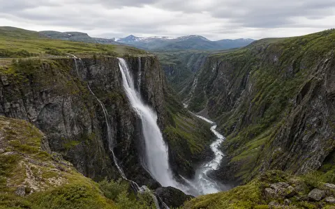
Plateau edge above Måbødalen
Vøringsfossen lies in Eidfjord municipality in Vestland, at the western margin of the Hardangervidda mountain plateau. Above the falls, the Bjoreio crosses the comparatively open upland terrain of Bjoreidalen and Sysendalen. At Fossli the river reaches a sharp break in relief and descends into Måbødalen, a much narrower and more deeply incised valley leading west toward Eidfjordvatnet.
This contrast between broad upland and confined lower valley is the essential landform setting. Glacial erosion helped deepen and steepen the valley system during the Quaternary, while meltwater and later river flow continued to cut along the inherited route. Erosion working back into the plateau margin created a pronounced valley head, leaving the modern river to cross the abrupt rock step as a waterfall.
Fall, gorge, and rock threshold
The commonly reported total fall is about 182 metres. The Bjoreio first passes through a confined rocky approach, then makes its main free-falling descent into the upper end of Måbødalen. The long open fall breaks into spray, especially when wind crosses the gorge or discharge is high, before the water gathers again among rock and debris at the base.
The waterfall is maintained by the steep bedrock threshold between the upland channel and the lower gorge. Water exploits joints and other weaknesses in the rock, while impact, frost action, and weathering loosen material around the fall and gorge walls. Rockfall supplies angular debris to the foot of the slopes, and the river carries finer weathered material downstream. These processes modify the edge gradually without removing the large contrast in elevation that sustains the falls.
High-plateau runoff and regulated flow
Bjoreio drains a substantial part of western Hardangervidda, and its wider river system also receives water from part of Hardangerjøkulen. The Isdølo, carrying runoff from the glacier area and adjacent uplands, enters the Bjoreio just above Vøringsfossen. Snow accumulates across the high plateau through winter, then thaw produces a dependable rise in runoff; the largest natural floods generally occur from late May into mid-July, often when snowmelt combines with rain.
Modern flow is strongly altered by hydroelectric regulation. Water from the upper Bjoreio and connected tributaries is transferred through the Sysenvatnet system toward Sima power station, reducing discharge through the natural channel and the falls. A required summer release maintains flow at Vøringsfossen from 1 June to 15 September. Outside that period, visible discharge depends more heavily on residual inflow, weather, snowmelt, and operating conditions within the regulated system.
About 182 m
The river descends from the plateau margin into the head of Måbødalen.
Bjoreio
A highland river draining western Hardangervidda and part of the glacier-fed uplands.
Plateau to gorge
The falls mark the transition from open upland valleys to a deep, confined lower valley.
From Hardangervidda to Hardangerfjord
Below Vøringsfossen, the Bjoreio continues west through Måbødalen and enters the southern side of Eidfjordvatnet. The lake also receives the Veig, another river draining western Hardangervidda. Its outlet, the Eio, runs for roughly two kilometres before reaching Eidfjorden, an inner arm of Hardangerfjord. The waterfall is therefore one steep link within a continuous plateau-to-fjord drainage system.
That sequence connects several forms of western Norwegian relief: high snow-storing plateau, incised mountain valley, low lake basin, short outlet river, and deep fjord. Vøringsfossen occupies the sharpest local break in this profile. Its position is controlled chiefly by inherited topography and bedrock, while the amount and timing of water crossing the edge now reflect both mountain climate and engineered transfers within the Eidfjord watercourse.