Overview
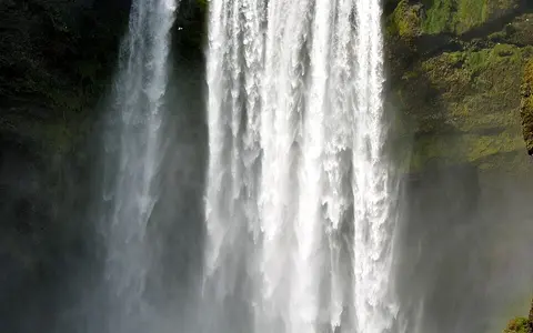
The waterfall stands at the mountain front near Skogar, where steep volcanic uplands meet the low country bordering Iceland's southern coast. The Skoga approaches across higher terrain and then crosses an abrupt break in slope. At the brink, a channel roughly 25 metres wide becomes a single main fall before the river resumes its course across the plain.
This sharp upland-to-lowland transition is the central geographic control. Most of the river's local loss of elevation is concentrated at the resistant cliff edge, producing a high plunge rather than a long sequence of rapids.
About 60 m
A near-vertical descent from the Eyjafjoll escarpment to the coastal lowland.
About 25 m
The Skoga spreads across a broad rock lip before entering the plunge zone.
Skoga River
A short south-flowing river linking wet uplands with the North Atlantic margin.
Volcanic escarpment and former coast
The cliff at Skogafoss is part of Iceland's layered volcanic terrain. Lava flows and other eruptive deposits built the upland, while erosion exposed differences in the strength and fracture pattern of successive rock units. A relatively resistant edge supports the crest; weathering, seepage, falling water, and rockfall continue to modify the face and the recess at its foot.
The escarpment also records an older coastal position. Marine erosion cut against the mountain front when the shoreline lay closer to it. Later sediment accumulation extended the lowland seaward, leaving the former sea cliff inland. Skogafoss now falls onto this younger plain rather than directly beside the ocean, making the waterfall a junction between volcanic bedrock relief and a depositional coastal landscape.
River profile and plunge-zone erosion
Above the falls, the Skoga occupies a bedrock channel interrupted by smaller cascades as it descends from the uplands. Skogafoss marks the largest single step in that downstream profile. At the base, impact and turbulence break the flow into spray and circulate water and sediment against the cliff foot.
These processes help clear fallen material and maintain a steep face. Frost action is also important: water enters joints, freezes during cold conditions, and can loosen blocks. The cliff edge therefore changes through small failures and erosion even though the overall escarpment continues to control the position and form of the fall.
Maritime runoff and changing flow
The Skoga drains high ground close to the ice-capped volcanoes and glaciers of south Iceland. Moist North Atlantic air is lifted over the rising terrain, bringing frequent precipitation. Rain, seasonal snow accumulation and thaw, and water stored in upland soils and fractured rock all contribute to the river.
Discharge varies with storms, snowmelt, and antecedent wetness. During high flow the falling sheet becomes thicker and the spray zone expands; during lower flow the rock lip and separate strands of water are more apparent. Winter freezing can build ice around the margins, while repeated freeze–thaw cycles increase weathering of the cliff.
Connection to the southern coastal plain
Below Skogafoss, the Skoga crosses a gently sloping plain assembled from river, glacial, volcanic, and coastal sediments. Its gradient is much lower than at the mountain front, so the river shifts from a plunging bedrock reach to an alluvial channel capable of moving and reworking loose material.
The river ultimately drains to the North Atlantic along Iceland's south coast. Skogafoss is therefore one element in a short mountain-to-ocean system: water moves from wet uplands, crosses a former sea cliff in a single major fall, and then traverses the sedimentary lowland to the coast.