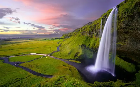
South Iceland escarpment setting
Seljalandsfoss lies in the western Eyjafjöll, near the boundary between the farms of Seljaland and Hamragarðar. Here the mountain front rises abruptly above the low, open plain of Landeyjar. The contrast between upland and lowland concentrates a large loss of elevation into a narrow zone and gives the Seljalandsá a distinct break in gradient.
The falls occupy one of several river notches along this mountain front. Nearby streams cross the same regional escarpment in different forms: some remain exposed on the cliff, while Gljúfrabúi descends within a narrow recess. Together, these falls mark the transition from steep volcanic terrain to sediment-covered coastal lowland.
Cliff, recess, and plunge form
The Seljalandsá makes a single principal plunge of about 60 metres. Its lip projects over a recessed section of the rock face, leaving open space between the falling water and the back wall. The stream is comparatively narrow, so wind can deflect the falling sheet and divide it into spray, especially during lower flow.
The cliff belongs to Iceland's volcanic landscape, built from layered lava and fragmental volcanic materials produced during repeated eruptive phases. Differences in resistance between layers, together with joints, weathering, and erosion by falling water, help maintain an uneven face. Water and frost loosen material within the damp recess, while impact at the base removes debris and limits the development of a smooth, continuous slope.
Runoff and maritime climate
Seljalandsá drains high ground beneath the ice-capped Eyjafjallajökull volcanic massif. Its flow responds to rain, thaw, and seasonal snow storage in the uplands. Moist North Atlantic air reaches southern Iceland frequently, and rising terrain encourages precipitation on the south-facing mountain belt. These controls sustain the stream but also produce substantial changes in discharge through the year and during storms.
Cold weather changes the fall without changing its underlying form. Spray freezes on shaded rock and at the cliff foot, while freeze–thaw cycles act on cracks in the face. Strong winds can spread the narrow cascade across the recess or carry part of it away as mist. The visible character of the waterfall therefore reflects both catchment supply and short-term atmospheric conditions.
About 60 m
The Seljalandsá plunges from the Eyjafjöll mountain front to the lowland below.
Recessed cliff fall
An overhanging lip and eroded back wall separate the falling stream from the cliff.
Rain and upland thaw
Maritime precipitation, snow storage, and melt govern the changing flow.
From upland stream to coastal plain
Above the falls, Seljalandsá is a small upland river crossing sloping volcanic terrain. At the escarpment it changes abruptly from a confined, steep channel to a free fall. Below the plunge, the channel leaves the mountain front and enters the much gentler Landeyjar lowland, where water and sediment move through the drainage network toward Iceland's southern Atlantic coast.
This mountain-to-plain sequence places Seljalandsfoss in a landscape shaped at several timescales. Volcanism constructed the bedrock highland; ice and rivers cut and modified its margins; and sediment accumulated across the low country in front. The waterfall persists where the modern river crosses that inherited boundary between resistant relief and the coastal depositional plain.