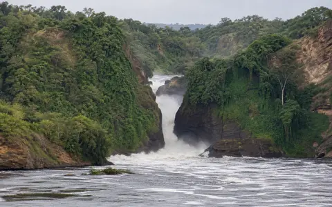
What Murchison Falls is
Murchison Falls lies on the Victoria Nile within Murchison Falls National Park in northwestern Uganda. It occupies the downstream part of the river's passage from Lake Kyoga toward Lake Albert, close to the eastern margin of the Albertine Rift.
The waterfall is defined less by exceptional height than by an abrupt change in channel form. Upstream water moving through a broad river reach is funneled into a rock cleft only a few metres wide, descends about 43–45 metres, and emerges into a lower gorge. Murchison is therefore best read as a linked sequence of approach channel, constriction, fall, plunge zone, and rift-basin outlet.
From broad channel to narrow gorge
As the Victoria Nile approaches the falls, its usable channel narrows rapidly. The same volume of water must pass through a much smaller cross-section, increasing velocity, turbulence, and contact with the gorge walls. Water then drops into a strongly agitated plunge reach before continuing westward.
A secondary spillway, known as Uhuru Falls, can carry part of the flow beside the main cleft when river levels are high. This means the active waterfall geometry can change with discharge even though the principal rock threshold remains fixed on a human timescale.
Broad Victoria Nile
Lake-fed flow reaches the brink through a comparatively wide upstream channel.
Six-to-eight-metre cleft
Resistant rock concentrates the river into a short, high-energy passage.
Gorge and widening river
The channel opens downstream as it enters lower, softer basin terrain.
Gneiss at the Albertine Rift margin
The falls cross ancient crystalline basement belonging to the Uganda Gneiss Complex. This resistant, locally sheared rock supports the narrow gorge and abrupt threshold. Erosion exploits fractures and weaker bands, but the strong rock confines the channel far more tightly than the sediment-filled reaches downstream.
Regional setting is equally important. Murchison Falls stands near small faults and escarpment relief along the eastern side of the Albertine Rift. Below the resistant plateau rock, the Victoria Nile enters softer rift-related sediments of the Lake Albert basin and develops a wider, slower channel. The falls mark this geological and topographic transition rather than a simple cliff isolated from its surroundings.
A lake-buffered reach of the White Nile system
The Victoria Nile begins at Lake Victoria, crosses central Uganda, and passes through Lake Kyoga before reaching Murchison Falls. These large upstream lakes store water and moderate short-term runoff pulses, helping maintain flow through the falls throughout the year.
Discharge still varies with rainfall, lake levels, upstream releases, and water losses across the connected lake-and-wetland system. Higher water can enlarge the active spillways and spray zone; lower water reveals more of the rock margins. The narrow gorge amplifies the visible effect of these changes by concentrating flow into a confined passage.
Tropical rainfall with a strong seasonal rhythm
The falls lie in a tropical interior climate moderated by plateau elevation and influenced by the seasonal movement of rain-bearing air across equatorial East Africa. Rainfall over the local catchment and the much larger upstream Nile basin is uneven through the year, while warmer conditions support substantial evaporation from lakes, wetlands, soils, and vegetation.
Local rain is only one control on the waterfall because much of its water arrives from distant parts of the Upper Nile system. The surrounding landscape shifts from wetter woodland and forest patches toward more open savanna and rift-valley terrain, but the immediate gorge retains a narrow spray-moistened zone beside the active channel.
From the East African plateau to Lake Albert
Below Murchison Falls, the Victoria Nile continues toward Lake Albert. Its gradient eases, the channel widens, and river-borne sediment is redistributed through the Murchison Falls–Albert Delta wetland system. The fall-to-delta sequence links erosion at the rock threshold with deposition in a shallow lake-margin setting.
Lake Albert also receives the Semliki River from the south. Water leaves the lake at its northern end as the Albert Nile and continues into the wider White Nile network. Murchison Falls therefore connects the waterfalls hub directly to the Nile River record and the terrain index.