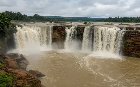
What Chitrakote Falls is
Chitrakote Falls lies on the Indravati River about 38–40 kilometres west of Jagdalpur in the Bastar district of southern Chhattisgarh. The river approaches across the gently rolling Bastar Plateau, reaches a broad break in its bed, and descends into a lower, more confined channel. The commonly reported drop is approximately 29–30 metres.
The waterfall is much wider than it is high. Its curved brink can carry several separated streams during lower discharge, while wet-season flow spreads across much more of the rock ledge and can approach 300 metres in width. That seasonal change is central to the landform: Chitrakote is a large-river cataract whose outline, number of falling channels, spray, and turbulence vary with the Indravati's discharge.
Broad brink, divided falls, and lower channel
Above the falls, the Indravati has a relatively broad channel and modest gradient. The waterfall begins where the river crosses a resistant bedrock threshold. The brink bends across the channel in a shallow horseshoe, so water does not leave the edge at a single narrow point. Instead, it uses low sections, joints, and channels across the ledge.
Falling water transfers energy into a turbulent plunge zone at the foot of the cliff. Hydraulic pressure, swirling sediment, weathering along cracks, and periodic block removal help maintain the sharp break in slope. The river then regathers below the fall and continues through lower plateau terrain. Over long periods, uneven retreat of the ledge preserves the irregular, multi-lobed shape of the crest.
Broad approach channel
The Indravati spreads across a low-gradient rock bed before reaching the brink.
Curved bedrock threshold
A long resistant ledge organizes the river into changing sheets and separate plunges.
Turbulent lower reach
Falling water, spray, and sediment concentrate erosion before the channel continues westward.
Sandstone beds of the Indravati Basin
Chitrakote lies within the Indravati sedimentary basin, a Proterozoic rock succession resting on the older crystalline foundation of the Bastar Craton. Geological work in the area places the falls within exposures of the Tirathgarh Formation, which includes quartz-rich arenite, other sandstone, conglomeratic beds, and thinner shale layers. The locally named Chitrakot Member is especially quartz rich.
These sedimentary beds are nearly horizontal or dip only gently. Resistant sandstone can support a broad lip, while fractures, bedding surfaces, and less durable layers provide routes for water and weathering. Differences in rock strength allow the cliff face to lose blocks unevenly rather than wear down as a smooth ramp, helping the river retain an abrupt drop across much of its width.
A large river with strongly seasonal discharge
The Indravati rises on the western side of the Eastern Ghats in Odisha and flows generally westward across the interior plateau before reaching Chitrakote. By the time it arrives at the falls, it has gathered runoff from a much larger area than the short headwater streams that feed many tall plunge waterfalls.
Discharge nevertheless changes sharply through the year. Sustained monsoon rain across the upstream basin raises water levels, activates more of the curved crest, and increases spray and sediment transport. During the drier months, the river contracts into several stronger channels and smaller threads, leaving sections of the bedrock ledge exposed. Storm runoff can also give the falling water a brown or reddish colour as fine sediment is carried from the basin.
Southwest monsoon and interior plateau seasonality
The Indravati sub-basin receives most of its annual rainfall during the southwest monsoon, broadly from June through September. Moisture arrives both with the wider monsoon circulation and with depressions that move inland from the Bay of Bengal. Repeated rain across Odisha and Bastar saturates soils, fills tributaries, and produces the broadest flows at the falls.
Winter is much drier, and hot pre-monsoon months increase evaporation while catchment storage declines. These seasonal controls affect the whole river rather than only the immediate cliff. Chitrakote therefore records weather accumulated across an upstream basin: its changing width and volume reflect the timing, intensity, and distribution of rain over a large part of the Indravati system.
From the Eastern Ghats to the Godavari
Upstream of Chitrakote, the Indravati links the western slopes of the Eastern Ghats with the plateaus of Odisha and Bastar. Downstream, it continues west, receives tributaries from forested uplands, bends south, and eventually joins the Godavari. Water and sediment passing over the falls thus remain within a much larger basin that ultimately drains east to the Bay of Bengal.
This basin-scale connection distinguishes Chitrakote from isolated escarpment falls. The waterfall is one step in a long river profile between eastern headwaters and the lower Godavari system. It connects most directly to the waterfalls hub, the rivers hub, the Eastern Ghats record, and the terrain index.