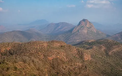
One geographic name, many hill systems
The geographic Eastern Ghats are the broken eastern uplands of the Indian Peninsula, not a surveyed line with universally agreed endpoints. The Indian Institute of Science's Digital Flora of Eastern Ghats includes Similipal as the farthest northern massif, the Odisha–Andhra Pradesh highlands, the central Andhra ranges, southern hill groups in Tamil Nadu, and the Biligirirangan sector in Karnataka. Its southern list continues beyond the Nilgiri junction to Sirumalai, Alagar, and Karanthamalai.
This record follows that broad physiographic usage. It does not treat every hill within the five-state envelope as part of one bedrock unit, and it does not use state or district borders to define the landform. A regional ecological study described a study mask more than 1,750 km long and about 100 km wide on average. Those figures describe the authors' mapped Eastern Ghats region, not a centerline measurement of a continuous range. (Babar and others, 2012)
Higher northern blocks, paired central ridges, scattered southern hills
North of the Godavari, the broadest high country lies around Koraput in Odisha and the Visakhapatnam–Paderu uplands of northern Andhra Pradesh. The Digital Flora places the Maliya and Madugula Konda ranges mostly between 900 and 1,400 m. The 2023 Alluri Sitharama Raju district report describes an upland surface near 900 m with several peaks above 1,200 m. These are sector measurements, not a range-wide mean.
Between the Krishna and Penna rivers, the central Ghats take a more legible north–south form. The Digital Flora traces two roughly parallel systems for close to 430 km: the lower Velikonda Range on the east, and the Palakonda–Lankamala–Nallamala system on the west. Farther south, the relief separates into the Nagari, Javadi, Shevaroy, Chitteri, Kalrayan, Kolli, and other Tamil Nadu hill groups before approaching the Biligirirangan and Nilgiri highlands. These local names are more precise than calling every segment simply “the Eastern Ghats.”
Massifs and high plateaus
Similipal, Koraput, and the Odisha–Andhra uplands contain the broadest and highest blocks.
Parallel hill systems
Velikonda lies east of the Palakonda–Lankamala–Nallamala chain between the Krishna and Penna.
Isolated plateaus and ridges
Named Tamil Nadu and Karnataka hill groups are divided by low plains, passes, and river valleys.
The high-point name and height are source-dependent
An Andhra Pradesh Space Applications Centre District Survey Report (2018) identifies Arma Konda or Jindhagada Peak near Paderu as one summit at 1,680 m above mean sea level and calls it the highest point of the Eastern Ghats. A 2005 MAUSAM paper independently lists Arma Konda at 1,680 m. This page uses the state report's combined name and datum.
The Digital Flora instead lists Jindhagada at 1,690 m and Arma Konda at 1,680 m as separate summits. Because that ten-metre difference is accompanied by a naming difference, it should not be averaged or presented as a second survey. A direct modern topographic feature record establishing two separate summit coordinates was not located; the 1,690 m value therefore remains a documented alternative, not the primary stat.
Deep-crustal rocks do not define the whole modern range
The best-known northern and central bedrock belongs to the Eastern Ghats Mobile Belt, a high-grade metamorphic terrane. “High-grade” means that earlier rocks were recrystallized at high temperature and pressure deep in the crust. Khondalite is a garnet- and sillimanite-bearing metasedimentary gneiss; charnockite is an orthopyroxene-bearing granitic rock; migmatite records partial melting and mixing of metamorphic and igneous material. The 2023 Alluri Sitharama Raju district report maps these units with quartzite, leptynite, and pegmatite and records regional folding, faults, and cross-folded domes and basins.
The mobile belt did not form in one event. A peer-reviewed synthesis describes separate crustal provinces affected by repeated metamorphism, magmatism, and deformation during Proterozoic supercontinent cycles; it also notes unresolved questions in the northern and northwestern belt. (Ganguly and Chatterjee, 2020) The present hills are younger landforms cut into those old rocks by weathering, stream incision, slope retreat, and removal of weaker material.
The geographic range is broader than this geological belt. The Nallamala and adjoining central ranges include sedimentary successions of the Cuddapah Basin, while southern Eastern Ghats hill groups lie in other crustal blocks. “Eastern Ghats” is therefore a valid physiographic label, but “Eastern Ghats Mobile Belt” is a narrower geological term and cannot be substituted for it throughout the page.
Denudation exposes resistant ridges and lowers the gaps
Denudation is the combined lowering of terrain by weathering, erosion, and mass movement. In the Eastern Ghats it has acted across deformed rock units with different strengths and fracture patterns. Quartzite and massive charnockite commonly support ridges, steep hills, and locally abrupt scarps; weathered gneiss, fault zones, sedimentary basins, and valley fills are more readily lowered into saddles, pediments, and broad corridors.
River incision reinforces that structural grain. Channels follow or cross faults and weaker bands, then widen their valleys as slopes retreat. This does not mean the major rivers simply “eroded away” one former continuous ridge: the modern pattern reflects inherited crustal structures, distinct rock provinces, basin margins, regional tilting, and long erosion operating together. The result is a mosaic of residual hills and dissected plateaus rather than the single west-facing escarpment characteristic of much of the Western Ghats.
Cross-range rivers connect plateau, gorge, plain, and delta
The Eastern Ghats are not a continuous drainage divide. The Mahanadi, Godavari, Krishna, Penna, and Kaveri rise west of major Ghats sectors and pass eastward through gaps or entrenched valleys. Their corridors separate physiographic blocks and carry water and sediment from large interior basins to coastal plains and Bay of Bengal deltas. The 2005 MAUSAM analysis traces storm systems inland through these river valleys and shows how much wider the low coastal plain becomes at the major deltas than beside the northern Andhra hills.
The lower Godavari provides a concrete cross-section. It narrows through the Papi Hills, receives the Sabari before the gorge, and re-expands near Polavaram; the Polavaram Project Authority locates the project where the river emerges from the last Eastern Ghats range and enters the plains. Shorter streams behave differently. The Vamsadhara, Nagavali, Sarada, Thandava, Gosthani, and other rivers gather runoff within or near the hills and descend directly to the coastal lowland, while the Indravati and Sabari drain northern highlands inland to the Godavari.
Flow is seasonal even where a named river is perennial. Wet-season runoff increases channel power, slope erosion, and sediment transport; dry-season flow contracts and depends more on basin storage, reservoirs, springs, and groundwater in weathered or fractured rock. The hard-rock aquifers are discontinuous: the 2023 district report describes groundwater in the Eastern Ghats Supergroup as fracture-controlled, with better yields along fractures than in intact rock.
Monsoon control changes from north to south
Northern Andhra highlands are dominated by the southwest monsoon. For Alluri Sitharama Raju district, the 2023 report uses a 1997–2021 series and gives mean annual rainfall of 1,327.22 mm, including 963.76 mm in June–September and 201.95 mm in October–December. These figures characterize one high northern district, not the Eastern Ghats as a whole.
Farther south, October–December rainfall becomes much more important. An India Meteorological Department study of Tamil Nadu data for 1896–2005 found a state-wide northeast-monsoon mean of 458.2 mm, with a standard deviation of 131.6 mm. Again, this is a Tamil Nadu average rather than a mountain-only value, but it documents the seasonal reversal affecting the southern hill groups. (Asokan and Sivagnanam, 2010)
Relief modifies these regional regimes without creating one uniform rain barrier. Elevation cools the high plateaus; slope orientation, distance from the Bay of Bengal, gaps, and exposure to monsoon depressions alter rainfall locally. The MAUSAM analysis places the Ghats close to the coast between northern Andhra Pradesh and southern Odisha but far inland and below about 550 m near the Krishna delta, explaining why coastal weather systems encounter very different barriers along the belt.
Data sources and publications
- Centre for Ecological Sciences, Indian Institute of Science. “Eastern Ghats,” Digital Flora of Eastern Ghats (accessed 30 August 2026). Broad physiographic scope, sector names, central-range length, elevation bands, river crossings, and alternative summit names and heights.
- Babar, S., Amarnath, G., Reddy, C. S., Jentsch, A., and Sudhakar, S. “Species distribution models: ecological explanation and prediction of an endemic and endangered plant species (Pterocarpus santalinus L.f.),” Current Science 102(8) (2012), 1157–1165. The greater-than-1,750 km length and approximately 100 km mean width describe the paper's broad Eastern Ghats study region.
- Andhra Pradesh Space Applications Centre and Department of Mines and Geology, Government of Andhra Pradesh. District Survey Report—East Godavari District (2018), pp. 4–5. Arma Konda/Jindhagada naming, 1,680 m above-mean-sea-level elevation, and the Godavari passage through the Papi Hills.
- Andhra Pradesh Space Applications Centre and Department of Mines and Geology, Government of Andhra Pradesh. District Survey Report—Alluri Sitharama Raju District (2023). Northern relief, 1997–2021 rainfall means, drainage, fracture-controlled groundwater, rock units, structures, and denudational landforms.
- Ganguly, P., and Chatterjee, A. “Geological evolution of the northern and northwestern Eastern Ghats Belt, India from metamorphic, structural and geochronological records: An appraisal,” Journal of Mineralogical and Petrological Sciences 115(2) (2020), 88–101, DOI 10.2465/jmps.190827b. Geological-belt scope, multiple metamorphic and magmatic events, separate crustal provinces, and remaining uncertainties.
- Malleswara Rao, P., and Jasmin, B. S. “Cyclone Prone Areas in the East Coast of India,” MAUSAM 56(3) (2005), 686–689. River-valley storm pathways, coastal-plain width transects, Andhra-sector elevations, and changing range position relative to the coast.
- Asokan, R., and Sivagnanam, N. “A Statistical Study of Northeast Monsoon over Tamil Nadu,” BREEZE 12(1–2), Regional Meteorological Centre Chennai, India Meteorological Department (2010), 24–31. October–December rainfall statistics for 1896–2005 and the southern seasonal regime.
- Polavaram Project Authority, Department of Water Resources, Government of India. “About—Polavaram Project” (accessed 30 August 2026). Position where the Godavari leaves the last Eastern Ghats range and enters the coastal plain.