What Mount Hekla is
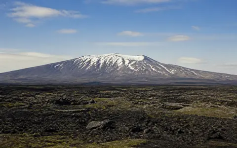
Hekla stands inland from Iceland's south coast, northeast of the Rangárvellir lowlands and west of the upper Þjórsá valley. The central volcano is the most prominent part of a volcanic system that extends for about 60 kilometres through southern Iceland. From the surrounding plains the edifice appears as a steep, narrow ridge rather than a uniformly radial cone.
The main mountain is about 9 kilometres long and roughly 3.5 kilometres wide near the 800-metre contour. Its crest follows the same ENE–WSW trend as the Heklugjá fissure. Hekla has no summit caldera and, unlike several other high volcanoes in southern Iceland, is not covered by a glacier; snow patches may persist on sheltered upper slopes.
A narrow crest above broad lava aprons
The mountain rises abruptly above rolling lava fields and older volcanic uplands. Its highest ground forms a chain of overlapping craters and short ridges, while lava flows spread outward onto gentler lower slopes. Seen across the ridge axis, Hekla can resemble a pointed cone; seen from the side, its long summit line is the dominant feature.
Successive lava flows have created lobate fronts, rough blocky surfaces, and overlapping aprons around the edifice. Tephra mantles both the mountain and the neighboring lowlands, smoothing some surfaces until wind and runoff expose the underlying lava. Older hyaloclastite ridges, formed by eruptions beneath ice during glacial periods, add irregular relief around parts of the wider fissure system.
Cratered summit ridge
Closely spaced vents and crater rims mark the line of the central fissure.
Layered composite slopes
Lava and fragmental deposits build steep upper sides around the ridge.
Overlapping lava fields
Flows fan outward and merge with plains formed by earlier eruptions.
A central volcano at a rift-transform junction
Hekla lies near the western edge of the Eastern Volcanic Zone, close to its junction with the South Iceland Seismic Zone. The volcanic zone is part of Iceland's active plate-boundary system, where extension and magma supply related to the Mid-Atlantic Ridge build new crust. The neighboring seismic zone accommodates movement between offset rift segments.
The central edifice and its summit fissure sit within a much longer fissure swarm that includes crater rows and lava-producing vents beyond the mountain. Hekla has erupted basaltic andesite and andesite most commonly, together with basalt, dacite, and rhyolite. Alternating lava effusion and explosive tephra production explain why the mountain has both a stratovolcano's layered relief and a fissure-controlled plan.
Lava, tephra, and wind-worked sediment
Young lava flows retain rough surfaces, pressure ridges, channels, and steep margins. With time, frost action breaks exposed rock into smaller fragments, while airborne dust and volcanic ash collect in hollows. The resulting ground is a patchwork of bare lava, thin soils, tephra sheets, and more continuous sediment on gentler lower slopes.
Tephra is especially important beyond the lava fields because wind can carry fine material far from the vents. Close to Hekla, repeated ash falls create distinct layers that can be redistributed after deposition. Strong winds move loose particles, while rain and snowmelt wash them into depressions and channels. These processes gradually soften fresh eruptive surfaces without erasing the outlines of individual lava lobes.
Runoff divided by porous volcanic ground
Hekla has no permanent summit ice cap or crater lake. Rain and melting seasonal snow descend the steep upper flanks in short channels, but surface drainage becomes less continuous across fractured lava. Water readily infiltrates permeable flows, enters groundwater, and reappears at springs around the margins of the lava fields.
Groundwater beneath the Hekla lava fields generally moves toward the southwest and helps feed the Ytri-Rangá system, whose headwater springs lie between Hekla and Búrfell. Other slopes connect to local streams and the wider Þjórsá drainage region. Fresh tephra can temporarily alter this pattern by sealing surfaces, increasing sediment supply, and making rain or snowmelt runoff more rapid.
North Atlantic weather over an exposed ridge
Hekla's climate is cool and maritime, shaped by southern Iceland's exposure to North Atlantic low-pressure systems. Moist air brings frequent cloud, rain, snow, and strong winds. Precipitation generally increases with elevation, while temperatures fall from the surrounding lowlands to the summit ridge.
Snow cover is seasonal over most of the mountain. Wind strips exposed crests and redistributes snow into gullies and sheltered hollows, where patches can last well into the warmer part of the year. Repeated freezing and thawing loosen rock on the upper slopes, and snowmelt supplies brief pulses of runoff to otherwise dry channels. The absence of a glacier means Hekla's drainage is not dominated by sustained ice melt or glacial outburst floods.
Between southern lowlands and volcanic highlands
Hekla occupies a physical transition between the lower, more continuously vegetated terrain of southern Iceland and the colder volcanic interior. Rangárvellir lies to the southwest, the broad Þjórsá corridor lies to the east, and the rhyolitic highlands of Torfajökull rise farther east. Lava fields and tephra from Hekla extend across this regional boundary and overlap terrain produced by neighboring volcanic systems.
The mountain connects deep tectonic structure to surface geography: rifting guides the fissure swarm, repeated eruptions build the ridge and lava plains, porous flows organize groundwater, and the North Atlantic climate controls snow, weathering, and sediment movement. Within the volcanoes hub, Mount Hekla is a useful example of a composite volcano whose form is governed by a long-lived summit fissure rather than a single central crater.