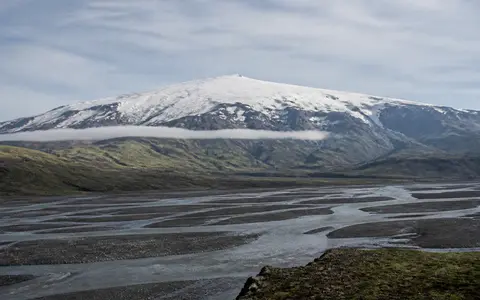
What Eyjafjallajokull is
Eyjafjallajokull stands between the Atlantic coastal lowlands to the south and the Markarfljót drainage basin and interior uplands to the north. The name commonly refers both to the ice cap and to the volcano beneath it. The volcanic system is elongated from east to west, extending roughly 25 kilometres by 15 kilometres, and its central high ground is covered by glacier ice.
The mountain is not a single sharp cone. Its wide flanks are assembled from lava flows and fragmental volcanic material, then cut by steep ravines and glacier valleys. A summit caldera about 2.5 kilometres across lies beneath the ice, while fissures and subsidiary vents extend onto the flanks beyond the main summit area.
A high massif above two contrasting lowlands
The volcano's southern side rises steeply behind a narrow coastal plain. Short valleys descend from the ice margin through cliffs and lower slopes toward low ground near the North Atlantic. To the north, the terrain opens into longer valleys and the broad Markarfljót basin, which separates Eyjafjallajokull from the highlands farther inland.
Elevation changes rapidly from near sea level on the south side to roughly 1,650 metres around the summit. Ice, running water, rockfall, and debris flows have dissected the original volcanic slopes, leaving ridges between deeply incised channels. The result is an asymmetric massif whose form reflects both lava-built construction and strong erosion.
Steep coastal face
Short valleys cross abrupt relief between the ice cap and the Atlantic lowland.
Ice-filled caldera
Glacier ice conceals much of the central depression and active vent area.
Outlet-glacier valleys
Ice and meltwater descend toward tributaries of the Markarfljót basin.
A composite volcano within Iceland's rift system
Eyjafjallajokull is a central volcano made from overlapping lava flows, tephra, breccia, and other eruptive deposits. Basaltic to andesitic magma has fed flank fissures and lava flows, while more evolved magma has also erupted from the summit area. Lava fields are especially evident on the western side of the system.
The volcano belongs to the southern part of Iceland's Eastern Volcanic Zone. Volcanism here is connected to plate spreading along the Mid-Atlantic Ridge and the unusually strong magma supply beneath Iceland. Eyjafjallajokull's east–west form and central caldera distinguish it from a simple fissure swarm, but its flank vents still link the main edifice to the wider zone of crustal extension.
Glacier ice draped over volcanic topography
A compact temperate ice cap covers the summit and upper slopes. Snow accumulating at high elevation is compressed into ice that flows outward, following depressions in the buried bedrock and volcanic surface. Gígjökull drains northward through a breach in the summit caldera, while Steinholtsjökull lies nearby on the northern side and Kaldaklifsjökull occupies the southeastern sector.
The glacier rounds some upper surfaces but concentrates erosion in outlet valleys, where moving ice removes rock and carries volcanic debris downslope. Moraines, outwash deposits, and exposed rock in front of retreating outlets record changes in ice extent. Because the glacier rests directly over vents and warm volcanic ground, eruptions can alter its surface and drainage much faster than climate alone.
Meltwater divided between coast and interior basin
Water leaves the ice cap in several directions. Northern meltwater follows outlet-glacier valleys toward the Markarfljót river system, while southern drainage descends by shorter, steeper routes to the coastal plain and the Atlantic. Snowmelt and heavy rain can rapidly increase runoff because the steep upper catchments funnel water into confined channels.
Subglacial eruptions add another hydrologic process. Heat from magma can melt large volumes of ice, releasing sudden jökulhlaups, or glacial outburst floods, loaded with sediment and blocks of ice. During the 2010 summit eruption, floodwater moved both north and south from the ice cap. Such events rework channels, spread sand and gravel across low ground, and show how volcanic and glacial systems jointly shape the surrounding terrain.
A maritime mountain exposed to North Atlantic weather
Eyjafjallajokull has a cool maritime climate controlled by its south-coast position and exposure to moist North Atlantic air. Frequent low-pressure systems bring cloud, rain, and snowfall, and rising air over the massif increases precipitation on the high slopes. Temperatures fall with elevation, allowing snow and glacier ice to persist above the comparatively mild coastal lowland.
Wind redistributes snow across the summit, stripping exposed ridges and loading sheltered hollows. Seasonal melting sends water and sediment into the radial valleys, while longer-term shifts in temperature and snowfall change the extent and thickness of the ice cap. Dark volcanic ash can temporarily absorb more solar energy than clean snow and accelerate surface melting where it settles on the glacier.
Between the south coast and Iceland's volcanic interior
Eyjafjallajokull occupies a transition between Iceland's settled coastal fringe and the volcanic and glaciated uplands of the interior. The larger Mýrdalsjökull ice cap and Katla volcanic system lie to the east, while the Markarfljót basin curves around the northern side. Together these features create a region of ice-covered volcanoes, steep mountain fronts, braided river channels, and sediment-built lowlands.
The volcano also connects several physical systems vertically: North Atlantic moisture becomes summit snow, snow feeds the ice cap, ice flows into outlet valleys, and meltwater carries volcanic sediment toward rivers and the coast. Within the volcanoes hub, Eyjafjallajokull provides a clear example of how a composite volcano's structure is modified by glacier flow, maritime climate, and eruption-driven floods.