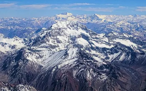

What Aconcagua is
Aconcagua is a mountain massif in the central Andes and the highest summit in the Andes. It stands in Argentina's Mendoza Province, east of the international boundary with Chile. Its great local relief comes from the elevation of the cordillera above deeply cut valleys and foreland terrain to the east.
Although Aconcagua is sometimes described as an extinct volcano, it is not a volcanic edifice. The massif contains volcanic rocks, together with sedimentary units, but its present form reflects deformation and uplift associated with Andean mountain building, followed by erosion and glacial modification.
Position in the central Andes
The massif lies in the Principal Cordillera, the high western division of the Andes in this part of Argentina. The Chilean border runs nearby along the main Andean divide, while the upper Horcones valley opens eastward toward the Mendoza River corridor.
Aconcagua is not a single smooth cone. Ridges extend from a high summit block toward subsidiary peaks and valley heads, and large differences in elevation separate the crest from the Horcones valleys. This arrangement places the mountain within a connected belt of high relief rather than above an isolated lowland plain.
Uplifted rocks, ridges, and steep faces
Rock layers in and around Aconcagua record marine sedimentation, volcanic activity, burial, faulting, and compression before the modern relief developed. During Andean uplift, these rocks were folded and faulted into the rising cordillera. Subsequent erosion exposed bands of differently resistant material across the massif.
The mountain's south face forms its most abrupt wall, while the northern and northwestern flanks descend through high ridges, talus-covered slopes, and broad debris surfaces. Freeze-thaw action breaks exposed rock, feeding scree and rockfall deposits into gullies and valley floors.
High crest and ridges
The summit belongs to an irregular massif with several connecting spurs.
South face
A steep wall gives way to glacier-cut valleys below.
Mountain building
Compression and uplift, not cone-building eruptions, produced the main landform.
Glaciers and headwater valleys
Glaciers occupy several high valley heads and shaded sectors of the massif. The Horcones Inferior Glacier descends below the south face, while other ice bodies and perennial snowfields occur on the eastern and northeastern sides. Their extent is limited by the region's low precipitation as well as by temperature and slope exposure.
Meltwater and seasonal snowmelt drain into the Horcones system and then toward the Mendoza River. Short, steep streams carry abundant loose sediment, and valley floors contain mixtures of glacial debris, rockfall material, and deposits reworked by running water.
Aridity, altitude, and strong winds
The central Andes here are dry because the mountain belt stands east of the Pacific moisture source and west of Argentina's continental interior. Most moisture arrives with winter systems from the Pacific, but totals vary greatly with elevation and exposure. Lower valleys are sparsely snow-covered for much of the year, while the high massif remains cold.
Elevation produces low air pressure, intense solar radiation, and rapid changes between sun and shade. Strong westerly winds cross the crest and can create blowing snow and plume-like cloud near the summit. Frost weathering, snow redistribution, and wind exposure are therefore major controls on the visible surface.
Divide, valleys, and Andean context
Aconcagua belongs to the same compressional mountain system as the wider Andes. Nearby passes and valleys cut across or approach the main divide, while east-flowing drainage connects the high cordillera to the Mendoza River and the drier foothills beyond.
Within Geography Atlas, the record appears in the volcanoes hub because of the requested catalog grouping, but its physical form is better understood through the mountains hub. Its volcanic rocks record part of the region's geological history; they do not make Aconcagua a volcano.