
What the Yukon River is
The Yukon is the main drainage axis of the northwestern North American interior west of the continental divide. Its upper waters gather among the Coast Mountains and adjoining highlands of British Columbia and Yukon. The named river flows from Marsh Lake, passes through Whitehorse, follows a broad northwesterly arc across Yukon, and then turns generally west across Alaska to the Bering Sea.
The main stem links sharply contrasting terrain. Steep, partly glaciated headwaters give way to rolling plateaus, broad alluvial flats, confined bends, and finally a nearly level delta plain. Major tributaries extend the basin north toward the Brooks Range, south toward the Alaska Range, and east into the uplands of central Yukon.
Lake-fed headwaters and an interior arc
The upper river belongs to a chain of lakes and connecting channels fed by mountain snow, rainfall, and glacier melt. Headwater streams reach Teslin Lake, Tagish Lake, and Marsh Lake through linked basins among the Coast Mountains. The Yukon proper issues from Marsh Lake and flows through the narrow outlet reach above Whitehorse before entering a wider interior valley.
Below the confluence with the Pelly River at Fort Selkirk, the enlarged river continues northwest toward the Alaska border. In central Alaska it bends around uplands, receives the Porcupine and Tanana rivers, and flows west across increasingly broad lowlands. This sweeping course reflects the arrangement of mountain belts, plateaus, structural basins, and low-gradient sedimentary plains.
Plateau valleys, flats, and shifting channels
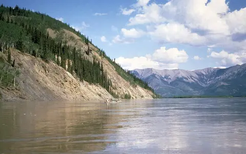
Across much of Yukon and eastern Alaska, the river occupies an incised valley within the Yukon Plateau. Bluffs and terraces border some reaches, while tributary mouths and wider basins contain floodplains, islands, sloughs, and gravel or sand bars. Local constrictions alternate with long open reaches, producing changes in current, sediment storage, and channel pattern.
Farther downstream, relief decreases and the floodplain widens. Meanders, cutoffs, bank erosion, and the growth of bars continually rework alluvium. Discontinuous permafrost occurs through much of the interior basin and becomes a major control on slope drainage, groundwater movement, bank stability, and the behavior of fine-grained floodplain deposits.
Mountain lakes
Linked lakes store runoff before it enters the named Yukon main stem.
Plateau corridor
Terraces, bluffs, islands, and tributary flats mark the passage through Yukon and eastern Alaska.
Alluvial lowland
A broad, low-gradient channel approaches the coast through mobile floodplain terrain.
A basin reaching into several mountain systems
The Teslin, Pelly, White, Stewart, and Klondike rivers join in Canada. The White is notable for its glacier-fed sediment load from the St. Elias Mountains, which adds pale suspended material to the main stem. In Alaska, the Porcupine enters from a long northern basin, while the Tanana delivers water and sediment from the Alaska Range and interior lowlands.
The Koyukuk joins farther west after draining country south of the Brooks Range. Together these tributaries collect runoff from coastal mountains, interior plateaus, the Alaska Range, and northern uplands. Their different snowpacks, glacier influence, rainfall regimes, and storage areas spread runoff generation across a very large basin.
Snowmelt, sediment, and seasonal ice
Winter freeze-up covers the river with ice and greatly reduces flow. Discharge rises in spring and early summer as lowland snow melts, river ice breaks, and mountain runoff reaches the main stem. Because breakup generally advances downstream toward colder reaches, moving ice can encounter intact cover, form jams, and temporarily flood valley flats.
Rain and continued high-elevation melt can sustain or renew summer flow. Tributaries carry gravel, sand, silt, and glacial flour into the Yukon; the main channel alternately erodes banks, transports sediment, and stores it in bars and floodplains. On the lower river, declining gradient and channel division encourage deposition before water reaches the sea.
Continental cold within a mountain-framed basin
The basin has a strongly continental subarctic climate, with long cold winters, short summers, and a large annual temperature range. Mountain barriers intercept moisture from the Pacific, leaving much of the interior comparatively dry. Even so, higher terrain receives deeper snow and supports glaciers that feed several southern tributaries.
Snow storage and the timing of thaw are primary controls on annual runoff. Permafrost limits deep infiltration in many northern and lowland areas, routing water through shallow soils and wetlands, while unfrozen ground beneath large channels permits local groundwater exchange. Year-to-year differences in snowpack, rainfall, and summer warmth alter both discharge and sediment delivery.
Yukon Delta and the Bering Sea
Near the western coast of Alaska, the river separates into distributaries across the northern Yukon–Kuskokwim Delta. The very low relief supports a dense pattern of channels, abandoned courses, ponds, wetlands, levees, and tidal margins. Floodwater and sediment are dispersed over a much wider area than along the confined interior river.
The distributaries enter Norton Sound, an embayment of the Bering Sea. Here river water, sea ice, tides, waves, and coastal currents interact across a shallow margin. The delta is therefore both the downstream sediment store of the river system and the transition between the continental basin and the marine shelf.
Northwestern interior to Pacific-margin sea
The Yukon basin lies between several major physiographic systems. Coast and St. Elias mountain headwaters connect it to the Pacific mountain margin; the Alaska Range supplies the Tanana; northern tributaries approach the Brooks Range; and the main stem crosses the plateaus and lowlands between them.
Within the atlas, the Yukon is a useful counterpart to the Mackenzie River. Both drain cold, permafrost-influenced interiors and experience strong snowmelt and ice-breakup cycles, but the Mackenzie flows north to the Beaufort Sea while the Yukon arcs west to the Bering Sea. The comparison shows how continental divides and mountain geometry route neighboring northern basins toward different ocean margins.