
What the Tagus River is
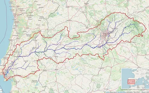
Known as the Tajo in Spanish and the Tejo in Portuguese, the Tagus is the principal west-flowing drainage axis of the southern half of Iberia's central plateau. It runs generally westward across Spain, forms a short section of the Spain–Portugal boundary, and continues through Portugal to the Atlantic.
The basin is elongated from east to west. The Central System forms much of its northern divide, while the Montes de Toledo and related uplands separate it from the Guadiana basin to the south.
From upland valleys to the lower plain
The headwaters rise above 1,500 metres in the Montes Universales, part of the Iberian System. The upper river passes through limestone and forested upland terrain before entering the broad interior plateau. Farther west it alternates between open basins and entrenched reaches cut into older rocks of the Iberian Massif.
Near Toledo the channel occupies a pronounced bedrock loop. Downstream through Extremadura and the border country, narrow valleys and reservoir basins are common. In Portugal the valley broadens progressively across lower terrain and alluvial plains before reaching the estuary.
Tributaries from contrasting uplands
The drainage network is notably asymmetric. Northern tributaries descend from the Central System, where higher relief and greater precipitation generally support larger flows. These include the Jarama, Alberche, Tiétar, and Alagón systems. Shorter southern tributaries drain the drier Montes de Toledo and adjacent plateau country.
Mountain-fed headwaters
The upper Tagus and tributaries begin in high terrain of the Iberian interior.
Plateau and bedrock valleys
Broad basins alternate with confined reaches across central and western Spain.
Alluvial lowlands
Lower gradients in Portugal support wider valleys, floodplains, and tidal transition.
Seasonal flow under Mediterranean controls
Most of the basin has a Mediterranean-influenced climate, with cool-season precipitation and hot, dry summers. Runoff therefore tends to be higher in winter and spring and lower in summer, although elevation, Atlantic influence, and rainfall vary substantially from the eastern headwaters to western Portugal.
Reservoirs regulate much of the main stem and several tributaries, modifying the timing and size of downstream flows. Water transfers and withdrawals also affect discharge, so the present hydrograph reflects both seasonal climate and extensive basin management.
A broad tide-shaped Atlantic outlet
Below the lower alluvial valley, the Tagus expands into a large estuarine basin commonly called the Mar da Palha. Extensive shallow margins, mudflats, marshes, and channels occupy its inner reaches, while a narrower passage beside Lisbon connects it to the Atlantic coast.
Semidiurnal tides move through the estuary and mix with river discharge. This tidal reach is not a simple river delta: it is a broad estuarine transition shaped by marine water levels, sediment exchange, and freshwater inflow.
Connections across central Iberia
The Tagus basin lies between the Duero drainage to the north and the Guadiana drainage to the south. Its westward course follows the overall tilt of the Iberian interior toward the Atlantic, while its tributaries transfer water and sediment from the surrounding mountain and plateau margins.
This terrain-to-ocean sequence makes the river a useful counterpart to other European records: unlike the Alpine-fed Rhine or the Black Sea-bound Danube, the Tagus is primarily an Iberian plateau river with a directly Atlantic estuary.