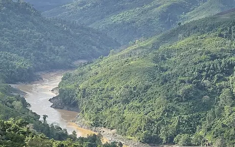

What the Salween River is
The Salween drains a long north–south basin on the eastern side of High Mountain Asia. Its headwaters rise on the Tibetan Plateau, and its main channel runs through western Yunnan before crossing Myanmar and reaching the coast near Mawlamyine.
Unlike rivers that build broad interior plains along much of their courses, the Salween remains closely tied to mountain relief. Narrow valleys, bedrock gorges, steep tributaries, and isolated alluvial pockets dominate until the lower river approaches its estuary.
From plateau headwaters into parallel ranges
Headwater streams gather in cold, high terrain of the eastern Tibetan Plateau. Flowing generally southeast and then south as the Nu Jiang, the river enters a zone where major Asian rivers occupy nearby but separate valleys divided by high ridges.
In western Yunnan, the Salween runs roughly parallel to the upper Mekong River and the Yangtze drainage. This close spacing reflects the strongly dissected relief of the Hengduan mountain region: short distances across the ranges separate river systems whose waters ultimately reach different seas.
A narrow corridor through eastern Myanmar
After leaving China, the Thanlwin crosses the uplands of eastern Myanmar. The main valley cuts southward through the Shan Plateau and adjoining mountain belts, while tributaries descend from both sides through steep, branching valleys.
Farther south, part of the river and the lower Moei, or Thaungyin, system mark sections of the Myanmar–Thailand boundary. The basin remains elongated and relief-bound, and extensive low-gradient floodplain reaches are limited compared with those of the neighboring Mekong or Irrawaddy systems.
High plateau sources
Cold headwater terrain supplies runoff to the south-flowing Nu Jiang.
Deep mountain valleys
Closely spaced ridges and gorges confine the main stem and its tributaries.
Estuarine lowland
The channel finally opens into tidal reaches and coastal alluvium near its outlet.
Seasonal rain, highland runoff, and rapid tributaries
Summer monsoon rainfall provides the main seasonal control on discharge through much of the basin. Flow rises during the wet season as rain falls on the mountain slopes and tributary catchments of Yunnan and Myanmar, while the cooler dry season brings lower water levels.
Snow and glacier melt contribute in the high headwaters, but their relative importance decreases downstream as monsoon rainfall and tributary inflow become dominant. Steep valley gradients allow runoff and sediment to move quickly toward the main channel, producing marked seasonal contrasts without creating one continuous broad floodplain.
Elevation and monsoon exposure
The basin crosses a strong climatic gradient. The upper plateau is cold and comparatively dry, while lower-latitude mountain slopes receive warmer and generally wetter monsoon conditions. Local rainfall varies sharply because ridges lift moist air on exposed slopes and place neighboring valleys in rain shadows.
These contrasts help explain the river's hydrology: high elevation preserves seasonal snow and ice in the north, mountain relief concentrates fast runoff, and the southwest monsoon supplies most of the lower basin's annual water during a distinct wet season.
Side valleys feeding a confined main stem
Myanmar tributaries such as the Pang, Teng, Pawn, and Hsim drain uplands west and east of the main river. The Moei, known in Myanmar as the Thaungyin, enters from the southeast after following a long boundary valley.
Because many tributaries fall rapidly from surrounding high ground, their confluences connect small upland catchments and intermontane basins to the trunk river. Bars and local alluvial flats occur around some junctions, but bedrock confinement remains a defining feature of much of the network.
Tidal channels at the Gulf of Mottama
Near Mawlamyine, the Salween reaches low coastal terrain and becomes part of a wider estuarine network that also receives the Gyaing and Ataran rivers. Channels divide around Bilu Island before opening into the Gulf of Mottama, an arm of the Andaman Sea.
The outlet is shaped by the interaction of river discharge, sediment delivery, strong tides, and coastal currents. This estuarine ending is a sharp final transition from the narrow, high-relief corridor that characterizes most of the river upstream.