
What the Rio Grande is
The Rio Grande is the principal river corridor of the southern Rocky Mountain and Chihuahuan Desert region. It rises in southwestern Colorado, crosses New Mexico from north to south, enters the broad El Paso–Ciudad Juárez basin, and turns southeast at the edge of the Mexican Plateau. From there it traces a long international boundary before reaching the Gulf.
The basin covers parts of the United States and Mexico. Its channel connects sharply contrasting landscapes, but the drainage network is not equally integrated everywhere: dry climate, permeable basin fill, irrigation, reservoirs, and diversions reduce or interrupt flow in some reaches.
Mountains, rift valleys, and desert basins
In the upper basin, short mountain tributaries descend from the San Juan Mountains into the San Luis Valley, a high, sediment-filled basin. The river then enters the Rio Grande gorge and follows the north–south Rio Grande Rift through a chain of structural basins in New Mexico. Fault-bounded uplifts and volcanic tablelands frame much of this corridor.
South of New Mexico, the river crosses the Basin and Range and Chihuahuan Desert region. Broad alluvial basins alternate with mountain blocks, while downstream plateaus and resistant bedrock locally confine the channel. Near the Gulf, relief diminishes and the river enters the coastal plain.
From gorge to floodplain
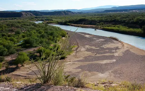
The upper river occupies both open valleys and confined bedrock reaches. In northern New Mexico it cuts the Rio Grande gorge through volcanic terrain. Farther south, wider alluvial valleys contain floodplain surfaces, terraces, sand bars, and shifting channel deposits built from sediment carried out of surrounding uplands.
Along the Big Bend region, the river bends around the northern edge of the Mexican highlands and passes through steep limestone canyons, including Santa Elena, Mariscal, and Boquillas. Below these confined reaches, the lower course gradually enters broader valleys and a low-gradient coastal plain.
Snow-fed highlands
Mountain runoff enters the San Luis Valley and the rift basins of northern New Mexico.
Desert corridor
Alluvial basins, reservoirs, irrigated valleys, and canyon reaches shape a highly variable river.
Coastal plain
The gradient eases as the river approaches its small mouth on the western Gulf.
Pecos, Conchos, and basin connections
Upper-basin tributaries such as the Chama connect additional Rocky Mountain snowfields and plateau terrain to the main stem. The Pecos River joins from the northwestern edge of the Great Plains and the dry uplands of eastern New Mexico and western Texas.
From Mexico, the Río Conchos drains part of the Sierra Madre Occidental and the interior plateau before meeting the Rio Grande near Presidio and Ojinaga. It is a major source of flow to the middle river. Farther downstream, the Salado and San Juan rivers connect northeastern Mexican basins to the lower course.
Snowmelt, summer rain, and water loss
Spring and early-summer snowmelt is the main natural high-flow control in the upper basin. Downstream tributaries respond more strongly to summer thunderstorms and occasional widespread rain, producing short flood pulses that may carry large sediment loads through otherwise dry landscapes.
Aridity becomes increasingly important away from the mountains. High evaporation, infiltration into alluvium, reservoir storage, and water withdrawals reduce discharge along the main stem. As a result, flow does not simply increase downstream; some sections lose water before major tributaries restore part of it.
Elevation and subtropical dryness
The basin spans a steep climate gradient. Cold, high-elevation headwaters accumulate winter snow, while much of the middle basin is semiarid or arid. Mountain ranges create local precipitation zones, but broad interior basins receive limited moisture and experience strong seasonal evaporation.
Summer monsoon circulation supplies thunderstorms to the upper and middle basin. In the lower basin, warm-season moisture from the Gulf of Mexico and occasional tropical systems can produce major floods. These different climate controls give tributaries distinct runoff timing and make discharge variable between years.
Reservoirs and altered sediment movement
Dams and diversion works regulate much of the river. Elephant Butte Reservoir stores water in central New Mexico, while Amistad and Falcon reservoirs occupy lower-basin reaches. These impoundments interrupt sediment transport and reshape the timing and size of downstream flows.
Between controlled releases, tributary inflow, withdrawals, and dry-channel losses, the modern river has a strongly segmented hydrology. Floodplain width, channel form, and riparian water availability therefore vary greatly along its course.
Lower valley and Gulf connection
Below Falcon Reservoir, the Rio Grande crosses the warm lower valley between northeastern Mexico and southern Texas. The surrounding terrain becomes flatter toward the coast, and fine alluvium forms a broad floodplain within the Gulf coastal plain.
The river reaches the Gulf of Mexico through a small, shifting mouth. Low discharge and wave-driven sand movement can build a bar across the outlet, while floods may reopen or reshape it. The mouth is the terminal link in a system extending from alpine snowfields to a subtropical coast.