
What the Colorado River is
The Colorado is the main drainage axis of a broad, mostly dry basin west of the Continental Divide. It rises in the mountains of north-central Colorado, flows generally southwest across the Colorado Plateau, passes through the Grand Canyon, and continues through the lower Colorado deserts before crossing into Mexico.
The main stem and its tributaries drain parts of seven U.S. states and two Mexican states. The Green River is the largest upper-basin tributary; the Gunnison, San Juan, Little Colorado, Virgin, Gila, and other rivers connect mountain ranges, plateaus, volcanic uplands, and desert basins to the trunk stream.
Rocky Mountain source to desert lowlands
The basin spans a pronounced elevation and moisture gradient. Alpine and subalpine headwaters along the Continental Divide receive much more precipitation than the downstream plateaus and basins. From these highlands, the river enters increasingly dry country where tributaries are more widely spaced and many smaller channels flow only after storms or seasonal snowmelt.
Across the Colorado Plateau, broad uplifts, nearly horizontal sedimentary strata, cliffs, mesas, and structural basins organize the river's course. Farther southwest, the channel reaches the Basin and Range province, where isolated mountain blocks alternate with sediment-filled desert valleys.
Canyons, gradients, and sediment
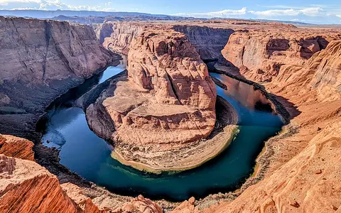
The river loses thousands of feet of elevation between its mountain source and the sea. Where it crosses uplifted plateau rock, a relatively steep gradient and sediment-bearing flow have driven sustained downcutting. Cataract Canyon, Glen Canyon, Marble Canyon, and Grand Canyon form a connected sequence of confined reaches separated from wider valleys.
Grand Canyon is the largest expression of this incision. The river cuts through uplifted sedimentary layers and into older crystalline rock, while tributary erosion widens the canyon system. In lower-gradient reaches, bars, terraces, floodplain patches, and alluvial valleys record sediment storage as well as erosion.
Mountain runoff
Snow accumulation and melt in the Rockies feed the main stem and major tributaries.
Bedrock canyons
Uplift, river gradient, and resistant strata produce deeply incised valleys.
Desert valleys
The river crosses hot lowlands and broad alluvial basins on its approach to Mexico.
Snowmelt, storms, and tributary timing
Much of the river's water originates as high-elevation winter snow in the Rocky Mountains. Meltwater historically produced a strong late-spring and early-summer rise, while summer monsoon storms can send short, sediment-rich floods through tributary canyons. Rainfall and snow vary greatly from year to year, so natural discharge is highly variable.
Aridity intensifies downstream: evaporation is high, and relatively little runoff is produced across much of the lower basin. The contrast between a wet mountain source and a dry receiving basin is therefore fundamental to the river's geography.
Dams, reservoirs, and altered flow
Large dams interrupt the modern long profile. Glen Canyon Dam impounds Lake Powell above Grand Canyon, and Hoover Dam impounds Lake Mead below it; additional dams and diversions occur along upper and lower reaches. The reservoirs occupy former canyon and valley segments and have changed the timing, temperature, and sediment load of downstream flow.
Regulation has muted the natural snowmelt flood pulse in many reaches. Sediment that once moved freely downstream is trapped behind dams, while tributaries continue to deliver sand and finer material below them. These changes affect channel bars, banks, and the physical form of the river corridor.
Delta and Gulf of California connection
Below the international border, the Colorado enters the low-relief delta plain at the head of the Gulf of California. Its distributary and tidal landscapes developed where river sediment met an energetic marine basin with a large tidal range.
The channel does not now reach the gulf continuously because upstream storage, diversion, and dry-basin losses greatly reduce terminal flow. Even so, the delta remains the geographic outlet of the drainage system and completes the basin's mountain-to-sea profile.