
What the Brahmaputra River is
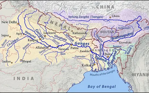
The Brahmaputra drains parts of the Tibetan Plateau, the eastern Himalayas, northeastern India, Bhutan, and Bangladesh. It changes name along its route: the upper river is widely known as the Yarlung Tsangpo in Tibet, the Siang or Dihang as it enters India, the Brahmaputra across Assam, and the Jamuna in Bangladesh.
Its physical character comes from extreme contrasts in elevation and climate. A high plateau course gives way to a sharp descent around the eastern Himalayan syntaxis, followed by a low-gradient floodplain river carrying water and sediment toward the Bengal delta.
Plateau reach, great bend, and mountain descent
The upper river runs generally east across southern Tibet in a long structural valley north of the main Himalayan crest. Near Namcha Barwa, it makes a great bend and descends through deeply incised terrain at the eastern end of the Himalayas.
This turn is the key relief transition in the system. The channel leaves a high plateau setting, cuts through a zone of steep slopes and rapid elevation loss, and emerges onto the foreland lowlands of northeastern India.
A braided river across the Assam Valley
In Assam, the river occupies a broad valley between the Himalayas to the north and hill ranges and plateau margins to the south. Its channel commonly divides around sandbars and alluvial islands, producing a wide braided belt that can migrate during major floods.
Bank erosion, channel switching, and deposition continually rework the floodplain. These are normal responses to high seasonal discharge, abundant sediment, and the reduced gradient beyond the mountain front.
Long upper valley
The Yarlung Tsangpo gathers runoff across high southern Tibet.
Rapid descent
The great bend and gorge reach connect plateau drainage to humid lowlands.
Braided channel belt
Multiple channels, bars, and islands mark the sediment-rich Assam reach.
Snow, ice, rainfall, and tributary flow
Upper-basin snow and glacier melt contribute to the river, but summer monsoon rainfall across the eastern Himalayas and Assam produces the strongest seasonal rise. Tributaries descend steeply from the Himalayas and from southern hill country, adding both runoff and sediment.
Because rainfall is concentrated in the warmer part of the year, discharge commonly increases greatly during the monsoon. High flows spread across low floodplain surfaces, reshape bars and banks, and move large sediment loads downstream.
From plateau dryness to humid monsoon margins
The basin spans a strong climatic gradient. The upper plateau is cold and comparatively dry, while the eastern Himalayan slopes and Assam Valley receive much heavier summer rainfall as moist monsoon air meets rising terrain.
Relief therefore controls both water supply and sediment production: high mountains store seasonal snow and ice, steep humid slopes generate rapid runoff, and the low valley receives the combined flood pulse.
Jamuna confluence and the Bengal delta
After entering Bangladesh, the main channel is known as the Jamuna. It joins the Ganges, locally called the Padma, and the combined flow later meets the Meghna before reaching the Bay of Bengal through a network of delta channels.
The lower course is therefore part of a connected Ganges–Brahmaputra–Meghna system. River discharge, enormous sediment transfers, tidal processes, and coastal flooding together shape the delta plain and its shifting distributaries.