
What the Flower Garden Banks are
Flower Garden Banks is both the traditional name of two prominent reef-capped banks—East and West Flower Garden—and the name applied to a wider protected network of banks in the same shelf province. In physical terms, the system is not one continuous barrier reef. It is an archipelago-like scatter of submarine elevations separated by broad tracts of deeper sand, mud, and open water.
East and West Flower Garden Banks have the broadest shallow coral caps. Stetson Bank, farther northwest on the middle shelf, is a hard-bottom bank that experiences cooler and more turbid conditions than the two main Flower Garden reefs. The wider group includes numerous shelf-edge banks whose crests, slopes, ridges, and intervening depressions occupy different depth zones.
Off the Texas–Louisiana margin
The banks lie in the northwestern Gulf of Mexico, roughly 129 to 201 kilometres offshore from Texas and Louisiana. Stetson and Sonnier are middle-shelf banks; most of the group stands nearer the outer shelf or upper continental slope. East and West Flower Garden Banks lie near 28° north, approximately south-southeast of Galveston.
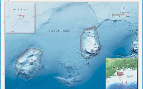
The reef banks form separate topographic islands rather than a joined tract. From Stetson Bank at the western end to Alderdice Bank in the east, the protected network stretches about 233 kilometres across the margin. East and West Flower Garden are about 19 kilometres apart, with seafloor deeper than 100 metres between their shallow caps.
Caps, terraces, flanks, and deep gaps
The defining relief is a repeated rise from the gently sloping continental margin to an isolated summit. At East and West Flower Garden Banks, the upper surfaces flatten into broad reef caps beginning roughly 17 to 25 metres below sea level. Around them, the seabed descends through reef slopes, deeper terraces, rocky outcrops, and sediment aprons toward shelf depths exceeding 100 metres.
Other banks vary markedly in form. Some are compact domes, some carry paired summits, and others appear as ridges, low-relief rings, troughs, or scattered hard-bottom patches. Stetson Bank rises from the middle shelf as uplifted siltstone and claystone outcrops, while the outer banks extend into mesophotic and upper-slope depths.
Reef-capped domes
East and West Flower Garden reach the sunlit upper water column but remain entirely submerged.
Stepped depth zones
Slopes and terraces link shallow reef caps with deeper hard bottom and sediment-covered shelf.
Open-water gaps
Deep intervening seafloor prevents the banks from forming a continuous reef barrier or lagoon.
Salt diapirs beneath the shelf
The regional bank topography originates in thick salt deposited when the early Gulf was a restricted, evaporating sea during the Jurassic Period. As the basin deepened, rivers buried the salt beneath denser layers of mud, silt, and sand. Under pressure, the relatively buoyant salt migrated upward through zones of weakness as diapirs, arching, faulting, and sometimes piercing the overlying sedimentary rock.
That deformation raised resistant material above the otherwise soft, gently graded seabed. Carbonate growth later occupied the resulting hard surfaces where depth, temperature, light, and water clarity permitted. The banks therefore combine a deep evaporite foundation, sedimentary-rock relief, and younger reef construction. A brine seep on the southeastern flank of East Flower Garden Bank is a direct surface expression of this salt geology.
Oceanic water above a river-fed basin
No streams drain onto the banks, and there are no islands or enclosed lagoons. Water passes freely over and around each summit. Tides contribute regular sea-level and current changes, while winds, eddies, and broader Gulf circulation produce stronger and less predictable flows across the caps and along the bank flanks.
The banks sit inside a Gulf basin that receives runoff from an immense continental watershed, including the Mississippi system. Yet their distance offshore and elevated summits usually separate the shallow reef caps from the strongest coastal sediment influence. Passing eddies can alter temperature, water clarity, and current direction, while movement between banks supplies the principal regional connection across the otherwise discontinuous hard-bottom landscape.
Subtropical seasonality and Gulf storms
The northwestern Gulf has warm summers, cooler winters, and strong year-to-year variation. Because the banks have no land surface or topographic shelter, sea temperature and atmospheric circulation control local conditions directly. Winter cold fronts can rapidly cool and mix the upper water column, especially over the more northerly and shallower Stetson Bank.
Tropical storms and hurricanes bring large waves, intense currents, and abrupt pressure and temperature changes. These events can move loose sediment and reef debris, scour exposed surfaces, and mix surface water down the bank flanks. Seasonal heating and cooling set the broad annual rhythm, while fronts, storms, and mesoscale eddies create shorter physical disturbances.
A chain along the continental margin
The Flower Garden Banks belong to a much larger field of salt-related highs scattered across the Texas–Louisiana shelf and slope. Each bank is geographically isolated at shallow depth, but currents link them to one another and to reefs farther south in the Gulf and Caribbean. Their position near the limits of warm-water reef development makes depth and winter temperature especially important controls on where reef-building structures occur.
Within Geography Atlas, the banks belong in the reef hub. Their isolated salt-dome foundations contrast with the continuous carbonate-platform margin of the Florida Reef and with the river-plume setting of the Amazon Reef.