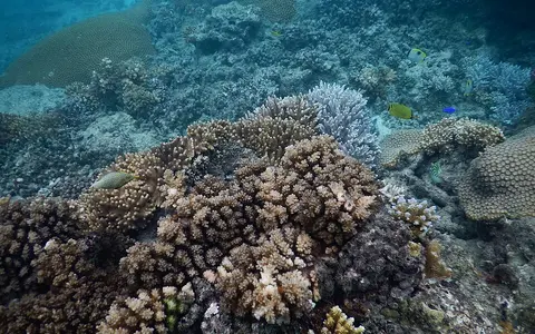

What the Fiji reef system is
Fiji's reefs are separate but regionally connected carbonate structures built on the shallow margins of islands and submarine highs. Narrow fringing reefs lie close to many shores. Elsewhere, barrier rims stand farther offshore and enclose lagoons containing patch reefs, sediment floors, and navigable passes. Platform reefs and reef-edged islands occupy shallower banks between the principal island groups.
The arrangement reflects inherited volcanic topography. Coral growth has extended and reshaped island shelves as volcanic relief weathered and sea level changed. Reef-derived sand and rubble form beaches, cays, and low coastal surfaces, while the main islands remain mountainous volcanic landforms rather than reef-built islands.
An archipelago between Melanesia and Polynesia
Fiji straddles tropical latitudes near 16–20° south and extends across a wide sector of the southwest Pacific. Viti Levu and Vanua Levu form the largest land masses. Taveuni lies southeast of Vanua Levu; the Yasawa and Mamanuca chains extend west and northwest of Viti Levu; and the Lau group reaches toward Tonga in the east.
Deep channels divide several island groups, while shallower shelves connect nearby islands and reef complexes. Bligh Water separates parts of Viti Levu and Vanua Levu, the Koro Sea occupies the central archipelago, and the Kadavu Passage opens southward. These waterways link enclosed lagoons with the open Pacific and Coral Sea sector.
Rims, lagoons, passages, and banks
Reef form changes with shelf width and exposure. Fringing reefs commonly follow island coasts, separated from land by shallow channels or narrow lagoons. Offshore barrier reefs trace shelf edges and may enclose much larger lagoon spaces. Passes interrupt the rims where tidal exchange, inherited valleys, and persistent currents maintain deeper openings.
Named systems illustrate this variation. The Great Sea Reef follows the northern margin of Vanua Levu and nearby islands. The Great Astrolabe Reef occupies the Kadavu region, where barrier and platform segments border lagoon water and steep outer slopes. Beqa Lagoon south of Viti Levu and the reefs of the Lau group represent other combinations of rims, patch reefs, islands, and open passages.
Fringing margins
Shallow reef flats and channels follow many volcanic coasts and embayments.
Barrier rims
Outer reef crests enclose lagoon floors and mark transitions toward deeper water.
Platforms and passages
Patch reefs and banks alternate with straits that funnel tides and ocean swell.
High islands above steep submarine slopes
Fiji is part of a tectonically complex island region between the Vanuatu and Tonga subduction systems. Most large islands are built of volcanic rocks, with rugged interiors, deeply cut valleys, and short coastal plains. Viti Levu reaches 1,324 metres at Mount Tomanivi, creating a sharp land-to-sea relief contrast over relatively short distances.
Below sea level, island shelves provide the main shallow foundations for reef growth. Their outer edges descend into deeper basins and troughs, so some barrier and platform reefs have steep seaward faces. Lagoon floors are gentler and accumulate carbonate sand, coral debris, and, near high islands, material delivered from weathered volcanic terrain.
River runoff and tidal exchange
Viti Levu and Vanua Levu contain permanent rivers fed by humid uplands. The Rewa, Sigatoka, Ba, and other drainage systems carry freshwater and terrestrial sediment toward deltas, estuaries, and reef-lined coasts. Runoff influence is strongest near river mouths and enclosed leeward waters, while outer barriers receive clearer open-ocean water.
Tides and waves move water through reef passes and over crests. This exchange ventilates lagoons and redistributes carbonate sediment across flats, beaches, and lagoon floors. Narrow passages can concentrate currents; broad windward rims absorb persistent swell, while sheltered sides favor finer sediment accumulation.
Trade winds, wet slopes, and tropical cyclones
Fiji has a tropical maritime climate shaped by warm ocean water, the South Pacific Convergence Zone, and the southeast trade winds. Mountainous islands create strong local rainfall contrasts: windward eastern and southeastern slopes are generally wetter, while western and northwestern districts lie partly in rain shadows.
A warmer wet season usually extends from November into April, when humid air, heavy rainfall, and tropical cyclones are more frequent. Cyclone waves can break reef framework, shift rubble, open or close shallow channels, and reshape cays and beaches. During the cooler trade-wind season, persistent southeast winds maintain stronger wave exposure on windward reef margins.
A crossroads of southwest Pacific waters
The archipelago lies where westward-flowing tropical surface water, trade-wind circulation, and complex currents around islands and passages interact. Fiji's reefs connect geographically with the reef-bearing island arcs of Vanuatu to the west, Tonga to the east, and New Caledonia farther southwest, but deep water separates these shelf systems.
Within Geography Atlas, Fiji belongs in the reef hub. Its high-island shelves and broken barriers compare usefully with the New Caledonia Barrier Reef, while its dispersed volcanic foundations contrast with the ridge-based Maldives Coral Reefs.