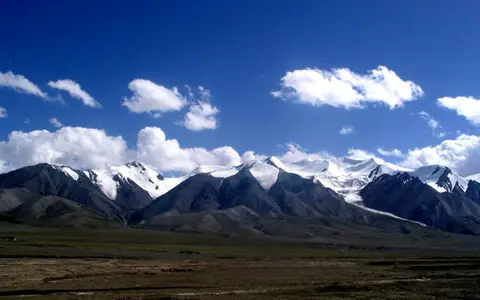

A range name with boundary-dependent measurements
Kunlun Shan is the Getty Thesaurus of Geographic Names’ preferred romanized form; Kunlun Mountains is its English form. The same record supplies the point 36.0085° N, 83.9940° E and describes a roughly 1,200-mile span from Tajikistan to Qinghai. Converted at 1.609344 kilometres per mile, that rounded source value is about 1,900 km. It is a catalog description, not a polygon or a measured ridgeline. (Getty TGN record 1109237)
A 2022 physical study instead defines the Kunlun as about 1,500 km west to east and up to 100 km north to south, divided into western, middle, and eastern sectors. The difference is geographic scope: wider gazetteer usage absorbs transitional western or northeastern highlands that narrower scientific study areas separate. This page follows the linked western-to-eastern plateau-margin sectors used in the scientific literature. It treats the Karakoram as the neighboring range west of the western Kunlun and does not apply Kunlun measurements automatically to the Altyn Tagh, Qilian, Pamir, or the Tibetan Plateau as a whole. No single range area is given because the cited sources do not provide a common surveyed outline. (Gagarin and others, 2022; Li and Shi, 1992)
Asymmetric slopes rise above desert and salt-basin floors
The western Kunlun face the southern Tarim Basin: north-flowing valleys descend abruptly toward desert piedmonts, while the range’s southern side merges more gradually with the high plateau. A glacier study measured the mean slope of its defined southern study area at less than 11°; outlet glaciers there spread beyond mountain passes, whereas northern glaciers are generally longer and steeper within tributary valleys. Those values describe the study’s western Kunlun glacier terrain, not the entire mountain system. (Guan and others, 2022)
Farther east, the Kunlun form the southern enclosure of Qaidam. A basin synthesis places Qaidam’s central floor at roughly 2,800–2,900 m above sea level and the eastern Kunlun rim above 6,200 m, a local floor-to-crest difference exceeding 3,300 m. Rivers cross the eastern range before spreading toward the basin floor; farther west, fans mark the transition from confined valleys to the Tarim piedmont. (Stober and others, 2023)
At 35°19′ N, 80°55′ E, a 1992 field paper reported Kunlun Peak at 7,167 m. Later glacier literature renders the name Luishi Shan (commonly Liushi Shan) and calls it the highest summit in its western Kunlun study region. Because neither publication states a modern vertical datum or a new geodetic survey method, 7,167 m is retained as a published elevation rather than presented with false survey precision or used to settle every broader definition of the range. (Li and Shi, 1992; Yasuda and Furuya, 2015)
Several old mountain-building episodes beneath younger relief
The Kunlun cannot be explained simply as a young fold range created by the India–Asia collision. Mapping and zircon dating in the eastern Kunlun identify Precambrian basement, sedimentary and metamorphic rocks, and large belts of arc-related granitic rock. That sector records separate episodes of ocean opening, subduction, and continental collision in the Neoproterozoic, early Paleozoic, and Late Paleozoic–early Mesozoic. In plain terms, fragments of crust and volcanic arcs were assembled here long before the present Tibetan Plateau existed. (Wu and others, 2019)
Cenozoic convergence between India and Asia then reactivated this inherited structure. In the eastern Kunlun, north–south shortening, thrust faults, and the east-striking left-lateral Kunlun fault—meaning the opposite side moves left when viewed across the fault—deform the older rocks. Wu and colleagues interpret the modern fault as reusing the mechanically weak Neo-Kunlun suture and report coordinated deformation since at least the late Miocene. This is a sector-specific tectonic history, not proof that every Kunlun ridge rose at the same time or rate. (Wu and others, 2019)
The fault and the mountain range also require separate measurements. The U.S. Geological Survey describes the Kunlun fault as roughly 1,600 km long and attributes the 14 November 2001 magnitude 7.8 Kokoxili earthquake to shallow left-lateral rupture on it. That 1,600 km figure is a fault-trace length; it is not evidence for the geographic length of the Kunlun Mountains. (USGS event and tectonic summary)
Repeated assembly
Ancient basement, former ocean sutures, arc rocks, and younger sediment record several tectonic cycles.
Transpression
Left-lateral slip combines with crustal shortening, producing fault-parallel valleys and thrust-bounded relief.
Incision and fans
Rivers cut uplifted blocks and transfer rock debris from steep valleys to piedmonts and terminal basins.
High ice in a cold, dry continental setting
Glacier totals depend strongly on the inventory boundary and date. For its western Kunlun study area, the Chinese Glacier Inventory counted 423 glaciers covering 2,965.35 km² in the 1970s; 17 glaciers larger than 50 km² contained 67% of that mapped ice area. Short field campaigns in 1987 and 1989 placed the mean equilibrium-line altitude—the elevation where annual accumulation approximately balances annual loss—near 5,930 m, with about 300 mm annual precipitation and a mean air temperature of −13.9°C near that line. These are historical regional observations, not present-day averages for all Kunlun sectors. (Guan and others, 2022)
Satellite records also show why glacier area alone can mislead. Guan and colleagues classified 18 western Kunlun glaciers as confirmed, likely, or possible surge-type glaciers. A surge is a short-lived acceleration that transfers ice down-valley and can advance a terminus without requiring colder climate or net mass gain. From 1972 to 2018 their combined surge-type area changed by −5.51 ± 3.74 km², while the mapped 1,093.00 km² of non-surge glaciers changed by −2.48 km². The same analysis found thinning before 2000 and slight thickening of surge-type ice during 2000–2016, so a single “stable” or “retreating” label would hide differences in period, glacier behavior, and measurement method. (Guan and others, 2022)
The adjoining basins demonstrate the elevation contrast. A recent study reports mean Tarim Basin precipitation below 50 mm per year, while precipitation variability at high Kunlun sites is controlled mainly by mid-latitude westerly airflow; summer monsoonal incursions can still produce rainfall at lower southern Tarim margins. Qaidam is likewise hyperarid. Elevation allows snow and glacier ice to persist above both basins, but exposure, slope, and circulation differ too much for one precipitation value to characterize the full range. (Shu and others, 2025; Stober and others, 2023)
Water leaves the mountains but not inner Asia
Most Kunlun drainage is endorheic: it terminates inland rather than reaching an ocean. On the Tarim side, the Yurungkax and Karakash descend from the western highlands and combine as the Hotan River, which crosses the Taklamakan toward the Tarim River. The Keriya drains another northern Kunlun sector but commonly loses flow within the desert system. Channel transmission is seasonal and affected by infiltration, evaporation, and water use, so a headwater connection does not imply continuous surface flow along every downstream reach. (Qin and others, 2019; Guan and others, 2022)
An HBV-light hydrological model for 1961–2016 estimated that glacier melt supplied 58.73% of runoff in the Hotan sub-basin, with glacier-melt runoff dominant in summer. This is a modeled component partition for a stated basin and period, not a gauged fraction for every Kunlun stream or a timeless percentage. A separate Hotan study found that different temperature and precipitation controls produce different runoff responses among the Tarim headwaters. (Wang and others, 2023; Wang and others, 2021)
Eastern drainage turns toward Qaidam. The Nalenggele, Golmud, and Xiangride rivers cross the eastern Kunlun and enter the closed basin. Their courses predate part of the present fault motion: geomorphic analysis inferred about 110 km of left-lateral offset for the Golmud drainage and about 90 km for the Xiangride drainage. These are reconstructed cumulative offsets of river systems, not modern channel lengths. (Yu and others, 2020)
Qaidam has no outlet to the sea. Its inflows end among playas, saline lakes, basin sediments, evaporation, and groundwater. Field sampling in 2008–2009 found that several southern inflows carry solutes recycled from windblown basin salt as well as material weathered from mountain rocks. Thus the Kunlun–Qaidam connection transports both water and sediment in two directions over time: rivers carry dissolved and solid material downslope, while wind can return salt-rich dust to the mountain catchments. (Stober and others, 2023)
Data sources and publications
- Getty Research Institute. Kunlun Shan, TGN ID 1109237 (accessed 30 August 2026). Preferred and English names, variant names, feature type, locator coordinate, and approximately 1,200-mile catalog extent.
- Gagarin, L., Wu, Q., Cao, W., and Jiang, G. “Icings of the Kunlun Mountains on the Northern Margin of the Qinghai-Tibet Plateau, Western China: Origins, Hydrology and Distribution,” Water 14, 2396 (2022). Defined 1,500 km by up-to-100 km study extent, western–middle–eastern segmentation, topography, and hydrology.
- Li Shijie and Shi Yafeng. “Glacial and lake fluctuations in the area of the west Kunlun mountains during the last 45,000 years,” Annals of Glaciology 16 (1992), 79–84. Western setting, Karakoram adjacency, summit coordinate and elevation, snowline observations, and glacial drainage.
- Yasuda, T., and Furuya, M. “Dynamics of surge-type glaciers in West Kunlun Shan, Northwestern Tibet,” Journal of Geophysical Research: Earth Surface 120 (2015), 2393–2405. Luishi Shan name and 7,167 m western-sector elevation; glacier geometry and surge behavior.
- Wu, C., Zuza, A. V., Zhou, Z., and others. “Tectonics of the Eastern Kunlun Range: Cenozoic Reactivation of a Paleozoic–Early Mesozoic Orogen,” Tectonics 38 (2019), 1609–1650. Eastern Kunlun scope, mapped rock assemblages, zircon ages, repeated arc collisions, suture reactivation, thrusting, and left-lateral faulting.
- U.S. Geological Survey. M 7.8 — Southern Qinghai, China, 14 November 2001 event page (accessed 30 August 2026). Magnitude, mechanism, tectonic setting, and approximately 1,600 km Kunlun fault length.
- Guan, W., Cao, B., Pan, B., and others. “Updated Surge-Type Glacier Inventory in the West Kunlun Mountains, Tibetan Plateau, and Implications for Glacier Change,” Journal of Geophysical Research: Earth Surface 127 (2022), e2021JF006369. Study boundary, 1970s inventory, historical field climate, glacier geometry, Landsat and DEM periods, surge classification, area change, and uncertainty.
- Shu, P., Zhou, W., Putnam, A. E., and others. “Intensified monsoonal rainstorm events over westerly-dominated Asian interior during the warm mid-Holocene,” Communications Earth & Environment 6, 72 (2025). Tarim–Kunlun setting, modern precipitation context, westerly control at elevation, and summer monsoonal incursions.
- Qin, Y., Li, B., Sun, X., Chen, Y., and Shi, X. “Nonlinear response of runoff to atmospheric freezing level height variation based on hybrid prediction models,” Hydrological Sciences Journal 64(13) (2019), 1556–1572. Hotan basin extent, the Yurungkax and Karakash tributaries, hydrometric stations, and runoff seasonality.
- Wang, A., Su, B., Huang, J., and others. “Runoff components and the contributions of precipitation and temperature in a highly glacierized river basin in Central Asia,” Frontiers of Earth Science 17 (2023), 361–377. HBV-light method, 1961–2016 analysis, Hotan sub-basin glacier-melt fraction, and seasonal runoff partition.
- Wang, X., Luo, Y., Sun, L., and Zhang, Y. “Different climate factors contributing for runoff increases in the high glacierized tributaries of Tarim River Basin, China,” Journal of Hydrology: Regional Studies 36 (2021), 100845. Hotan source region and differing modeled runoff controls among Tarim headwaters.
- Yu, X., Guo, Z., Chen, Y., and others. “River system reformed by the Eastern Kunlun Fault,” Geomorphology 350 (2020), 106876. Named Qaidam-bound rivers, antecedent drainage interpretation, longitudinal profiles, and reconstructed Golmud and Xiangride offsets.
- Stober, I., Zhong, J., and Bucher, K. “From freshwater inflows to salt lakes and salt deposits in the Qaidam Basin, W China,” Swiss Journal of Geosciences 116 (2023), article 5. Qaidam elevations, closed-basin setting, named Kunlun inflows, 2008–2009 sampling, solute sources, and terminal salt-lake processes.