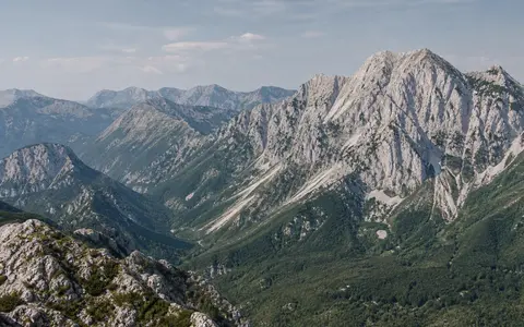
One mountain system, several working boundaries
Dinaric Alps is the accepted English geographic name; Dinarides is the usual tectonic name for the orogen. This page uses the names for the connected mountain system from the Karst and Alpine transition near Trieste and southwestern Slovenia, through Velebit, Dinara, the Bosnian-Herzegovinian highlands, Durmitor and neighboring Montenegrin massifs, to Prokletije—the Albanian Alps. It does not extend the Dinaric name through the Pindus Mountains or the wider Hellenides.
The endpoints are transitions, not surveyed corners. A DIKTAS hydrogeological review placed the northwestern fringe in the Classical Karst around Trieste and Udine but described the southern transition into the Pindus–Hellenide units as indistinct. Its project team included Albania's Vjosa catchment in a study area even though its hydrogeologists considered the Dinaric karst itself to end in the Albanian Alps. That project boundary is useful for groundwater management, but it is not adopted here as the range boundary. (DIKTAS hydrogeological review)
Maja Jezercë lies in the Albanian Alps. Albania's National Agency of Protected Areas gives its elevation as 2,694 m above sea level and identifies it as the highest summit of that range; a peer-reviewed regional account also identifies it as the highest peak of the Dinaric Mountains under an Albania-ending range definition. The agency does not specify a vertical datum or survey edition, so the value is retained at its published metre precision without further conversion. (Albanian National Agency of Protected Areas; Djordjevic, 2014)
Parallel to the eastern Adriatic
The southwestern edge follows the Adriatic coast and islands; the northeastern side descends through interior ridges and basins toward the Sava corridor and Pannonian lowlands. In Croatia and Bosnia and Herzegovina, the 2012 DIKTAS working boundary placed the Dinaric fringe roughly 20–30 km south of the Sava riverbed. This is a regional hydrogeological convention, not a precise toe-of-slope line. National borders cross the mountain grain and do not define its physical limits.
Northwest–southeast structure repeats at several scales. Long ridges such as Velebit stand close to the sea; Dinara and the central high-karst belt lie farther inland; broad plateaus and elongated poljes interrupt the crests; and the southeastern sector breaks into compact massifs around Durmitor and Prokletije. Transverse gorges locally cut across the structural grain, while some long valleys and coastal channels follow it. There is no single continuous crest and no authoritative centroid, so assigning one point coordinate would imply a precision the feature does not have. UNESCO's regional hydrogeological dataset instead maps polygons for Dinaric carbonate aquifers from northeastern Italy to Albania; those aquifer polygons overlap the range but are not a topographic boundary. (UNESCO-IHP hydrogeological dataset)
A former sea floor compressed into thrust belts
The outer Dinarides contain rocks of the former Adriatic Carbonate Platform. From the Late Triassic to the Middle Eocene, this shallow-marine platform accumulated a carbonate succession reported as roughly 5–8 km thick. That thickness describes a stratigraphic pile reconstructed across the platform, not the depth of limestone beneath every present-day ridge. Later shortening folded, faulted, and stacked the succession into the External Dinaric thrust belt. (Fiket and others, 2008)
A simple cross-range division separates the carbonate-rich External Dinarides beside the Adriatic from the Internal Dinarides to the northeast. The internal belt includes deep-water sediments, flysch, metamorphic units, and ophiolitic mélange—a faulted mixture containing fragments of former oceanic crust and associated rocks. Geological schemes subdivide these belts differently, so “external” and “internal” are useful regional orientations rather than two uniform rock masses. (Slovenec and others, 2023)
Mountain building occurred in stages. Vardar oceanic rocks were emplaced, or obducted, onto the Adriatic margin during the Late Jurassic to Early Cretaceous. Cretaceous and Paleogene deformation then assembled thrust sheets, and strong Late Eocene–Oligocene shortening and uplift helped establish the modern southwest-facing fold-and-thrust belt. Continued erosion exposed different structural levels and carried sediment toward the Adriatic margin, interior basins, and the Sava system. (Schmid and others, 2008; Slovenec and others, 2023)
Platform carbonates
Thick Jurassic and Cretaceous limestone and dolomite dominate much of the Adriatic-facing high karst.
Basins and oceanic remnants
Deep-water sediments, flysch, metamorphic rocks, and ophiolitic units make the interior geologically less uniform.
Nappes and faults
Nappes are large transported rock sheets; their stacking produced parallel ridges and tectonic depressions.
Dissolution redirects erosion below ground
Carbon dioxide absorbed by rain and soil water makes the water weakly acidic. It enters joints and bedding planes, dissolves limestone and dolomite, and enlarges connected openings. The resulting terrain includes closed dolines, bare limestone pavement, dry valleys, caves, sinking streams, and large springs. A ponor is a place where surface water sinks underground; a polje is a large, closed or partly closed karst depression with a comparatively flat floor. Many Dinaric poljes are elongated along faults or folds and contain patches of less permeable sediment that retain surface water.
Tectonics provides the fractures and basin geometry; dissolution and river incision modify them. A polje can be dry, marshy, lake-filled, or seasonally inundated as inflow and the capacity of its underground outlets change. Resistant carbonate blocks remain as scarps and plateaus, while rivers cut gorges where sustained surface flow crosses uplifted structures or where springs concentrate discharge. These processes explain why “limestone ridges” alone is an incomplete description of the range. (Stevanović and others, 2012)
A surface divide crossed by karst conduits
On the seaward side, the Soča, Zrmanja, Krka, Cetina, Neretva, Zeta–Morača, Buna/Bojana, and Drin systems reach the Adriatic or Ionian seas directly or through coastal lakes. On the inland side, the upper Kupa, Una, Sana, Vrbas, Bosna, Drina, Tara, and Piva feed the Sava or Drina and ultimately the Danube and Black Sea. This is a basin-scale pattern: individual rivers can run along the mountain grain, cut across it, disappear into carbonate rock, or be supplied by springs.
The 2012 DIKTAS assessment assigned 65,545 km² of its mapped four-country study area to the Adriatic basin and 44,865 km² to the Black Sea basin—approximately 59.4% and 40.6% of that 110,410 km² working area. Those figures quantify the Albania–Bosnia and Herzegovina–Croatia–Montenegro project area, not the entire natural mountain system, and should not be used as a permanent range-area statistic. (DIKTAS 2012 assessment)
Underground catchments must often be established with dye tracing rather than surface contours. Water may sink at a polje margin, pass beneath a ridge, and emerge at a spring in another valley or even on the opposite side of an apparent divide. Flow and spring discharge can change sharply between wet and dry seasons because large conduits transmit recharge rapidly while fractures and smaller pores store water differently. UNESCO's map consequently depicts a connected transboundary aquifer system extending from northeastern Italy through Slovenia, Croatia, Bosnia and Herzegovina, Montenegro, and Albania, with related carbonate outcrops farther inland. (UNESCO-IHP Dinaric Karst Aquifer System map)
Maritime moisture meets a steep barrier
Moist southerly and southwesterly flow from the Adriatic and wider Mediterranean is forced upward against the coastal ranges. Cooling during ascent favors condensation, rain, and high-elevation snow, while descending air and distance from the sea contribute to drier or more continental conditions in some interior basins. The contrast is not a simple coast-to-interior step: ridge height, exposure, valley orientation, and storm track produce large changes over short distances.
A Croatian–Montenegrin climatological analysis reported expected mean annual totals above 3,000 mm in Gorski Kotar and on Velebit and above 5,000 mm in the mountainous hinterland of southeastern Montenegro. These are regional climatological expectations assembled in a 2014 study, not current range-wide normals or summit records. In a sensitivity experiment for the 22 November 2010 southern Adriatic storm, removing Dinaric topography weakened the modeled mountain rainfall; the authors concluded that orographic lift supplied the largest mountain-scale contribution, while low-level convergence also mattered near Dubrovnik. (Ivančan-Picek and others, 2014)
Elevation lowers temperature and lengthens snow cover relative to adjoining lowlands. Enclosed basins can trap cold air during calm winter weather, whereas passes and gaps channel strong cross-barrier winds, including the cold downslope bora along parts of the Adriatic margin. No one station represents the 700 km belt, and the published precipitation examples above should not be extrapolated to every massif.
Separate ice caps and valley glaciers
Pleistocene ice did not form one continuous Dinaric ice sheet. It occupied individual plateaus and massifs as ice fields, ice caps, valley glaciers, and cirque glaciers. In central Montenegro, geomorphic mapping and 31 uranium-series ages indicate that joined ice caps covered nearly 1,500 km² before 350,000 years ago, during Marine Isotope Stage 12. The same reconstruction estimated about 720 km² during the later MIS 6 glaciation and only 49 km² of valley and cirque ice during the last glacial cycle. These are reconstructed areas for the studied central Montenegrin massifs, including Durmitor and Sinjajevina, not totals for the Dinarides. (Hughes and others, 2011)
The northern record was also local. A 2026 study of Trnovski Gozd in Slovenia reconstructed at least 6 km² of Last Glacial Maximum ice from landforms, while its preferred model produced 27.4 km²; the two numbers are different methods, not competing measurements to average. A terminal moraine was dated to 19.5 ± 2.1 thousand years ago using chlorine-36 exposure dating. Across the range, cirques, moraines, troughs, and glacial lakes therefore record strongly unequal ice extent controlled by elevation, exposure, and moisture supply. (Žebre and others, 2026)
From the Alpine junction to the Albanian Alps
In the northwest, Dinaric karst plateaus meet the southeastern Alps across a structurally complex transition rather than a clean gap. Southwestward, the mountain front and aligned islands border the Adriatic. Northeastward, drainage and sediment pass toward the Sava and Pannonian domain. At the southeastern end used here, Prokletije contains headwaters of the Valbona, Shala, Cemi, and Gashi before the regional tectonic grain continues into the Albanides and Hellenides under different names.
The Dinarides are therefore both a divide and a set of connections. Their ridges separate sea basins, their valleys guide rivers and sediment, and their carbonate aquifers carry water beneath visible divides. Use the mountain hub to compare the belt with other fold-and-thrust systems, while keeping its mapped karst aquifers, administrative regions, and neighboring ranges distinct from the physical feature.
Data sources and publications
- Slovenec, D., Belak, M., Badurina, L., Horvat, M., and Šegvić, B. “Triassic evolution of the Adriatic-Dinaridic platform's continental margins—insights from rare dolerite subvolcanic intrusions in External Dinarides, Croatia,” Comptes Rendus Géoscience 355 (2023), 35–62. Approximate 700 km extent, northwest–southeast orientation, External/Internal Dinarides, platform carbonates, ophiolitic mélange, and Late Eocene–Oligocene thrusting.
- Schmid, S. M., Bernoulli, D., Fügenschuh, B., Matenco, L., Schefer, S., Schuster, R., Tischler, M., and Ustaszewski, K. “The Alpine-Carpathian-Dinaridic orogenic system: correlation and evolution of tectonic units,” Swiss Journal of Geosciences 101 (2008), 139–183. Orogen-scale tectonic map, cross-sections, Vardar ophiolite obduction, and multiphase deformation.
- Fiket, Ž., Strmić Palinkaš, S., Palinkaš, L. A., Tari-Kovačić, V., Alajbeg, A., and Španić, D. “Organic geochemistry of source rocks from the Adriatic-Dinaric carbonate platform,” Geologica Carpathica 59(3) (2008), 225–236. Platform duration and the reported 5–8 km carbonate succession; the figure applies to the platform stratigraphy rather than every massif.
- Stevanović, Z., Kukurić, N., Treidel, H., Pekas, Ž., Jolović, B., Radojević, D., and Pambuku, A. “Characterization of transboundary aquifers in Dinaric karst—a base study for sustainable water management at regional and local scale,” 39th International Association of Hydrogeologists Congress (2012). Working boundaries, landforms, study-area dimensions, sea-basin partition, rivers, and tracer-based groundwater connections.
- UNESCO Intergovernmental Hydrological Programme. Hydrogeological Map of the Dinaric Karst Aquifer System, DIKTAS dataset (accessed 30 August 2026). GIS coverage and transboundary extent of mapped carbonate aquifers; not a polygon for the mountain range itself.
- Albanian National Agency of Protected Areas. Parku Kombëtar i Alpeve (accessed 30 August 2026). Maja Jezercë's published 2,694 m elevation and its status as the highest summit of the Albanian Alps; no vertical datum or survey edition is stated.
- Djordjevic, D. “International Agreements and Region-building in the Mountains of South East Europe,” Mountain Research and Development 34(1) (2014), 4–12. Albania-ending geographic scope and Maja Jezercë as the highest peak within the Dinaric Mountains so defined.
- Ivančan-Picek, B., Horvath, K., Strelec Mahović, N., and Gajić-Čapka, M. “Forcing mechanisms of a heavy precipitation event in the southeastern Adriatic area,” Natural Hazards 72 (2014). Regional precipitation climatology and model sensitivity tests separating orographic lift from low-level convergence.
- Hughes, P. D., Woodward, J. C., van Calsteren, P. C., and Thomas, L. E. “The glacial history of the Dinaric Alps, Montenegro,” Quaternary Science Reviews 30 (2011), 3393–3412. Uranium-series chronology and reconstructed ice areas for central Montenegro.
- Žebre, M., Sarıkaya, M. A., Depolli, M., Stepišnik, U., Çiner, A., Kosec, G., Wilcken, K., and Yıldırım, C. “LGM glaciation in the northern Dinaric Mountains, Slovenia: new insights from terrestrial cosmogenic nuclide dating and Parallel Ice Sheet Model simulation,” Boreas (2026). Trnovski Gozd empirical and modeled ice areas, exposure age, and remaining chronological uncertainty.