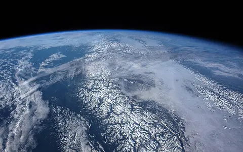

Which mountains this record covers
Coast Mountains is the official English name, and Chaîne Côtière is the official French form. The provincial name record places the system parallel to the coast from the Fraser River near Vancouver north into Yukon and gives 53°59′59″ N, 129°30′00″ W as its approximate centre in WGS84. Its historical notes also use Coast Range, but that singular form can be confused with wider or differently bounded coastal ranges in the United States; this page uses the official Canadian plural. (BC Geographical Names: Coast Mountains)
The often-quoted 1,600 km length is retained as a conventional description from the same provincial record, not as a GIS-derived perimeter or a measurement along every summit. Mountain margins merge into adjoining highlands, and the official record supplies neither a surveyed polygon nor a dependable range-wide width. The page therefore does not turn the representative coordinate into a centreline or repeat the record's loosely defined 300 km width.
The official subdivisions provide the clearest internal orientation. The Pacific Ranges extend from the Fraser River to Burke Channel; the Kitimat Ranges continue from Burke Channel to Portland Inlet; and the Boundary Ranges run from the Nass River northwest around the British Columbia–Alaska boundary and across the British Columbia–Yukon boundary. These are physiographic ranges, not administrative regions, and the international and provincial boundaries merely cross the northern mountain terrain. (Pacific Ranges record; Kitimat Ranges record; Boundary Ranges record)
High massifs, a lower middle reach, and transverse valleys
Relief is distributed unevenly. The Pacific Ranges contain the Mount Waddington massif and several broad southern icefields; the central Kitimat Ranges generally have lower summit levels; and the Boundary Ranges rise again among extensive northern icefields. Mount Waddington, northeast of the head of Knight Inlet, is the range high point. The current provincial feature record gives 4,016 m (13,177 ft). That catalogue value replaces the page's former 4,019 m, whose method could not be traced. (BC Geographical Names: Mount Waddington)
The mountains do not form a continuous wall. Valleys of the Taku, Stikine, Nass, Skeena, Bella Coola, Dean, Klinaklini, and Homathko rivers divide the belt into massifs. On the outer flank, valleys continue seaward as steep-sided inlets. In the central coast, for example, the province's physical-setting synthesis reports Burke Channel extending about 90 km into the mountains and Dean Channel about 95 km; those are inlet lengths within the central-coast study area, not measures of the whole range. (Central Coast physical setting, pp. 22–23)
A long-lived plutonic belt, not one body of granite
Much of the exposed core belongs to the Coast Plutonic Complex. A pluton is magma that crystallized below the surface; the complex is a mosaic of many such bodies—including tonalite, diorite, granodiorite, and granite—together with screens and belts of older metamorphosed volcanic and sedimentary rock. Uplift and erosion exposed these rocks from below the surface. It is therefore more accurate to describe the Coast Mountains as a plutonic–metamorphic belt than as a single granite batholith.
Its magmatic history was prolonged and spatially variable. A detailed study of the eastern complex around Bella Coola (51–54° N) identified Jurassic-to-Eocene intrusions representing more than 140 million years of nearly continuous subduction-related magmatism. Farther west on the north and mid-coast, 1:150,000 mapping shows metamorphosed Alexander terrane rocks cut by eastward-younging Late Jurassic-to-Paleocene plutonic belts. These regional age ranges describe crystallization of the rocks, not the age of the present peaks or fjords. (Mahoney and others, 2009; Nelson and others, 2014)
Younger volcanism is superimposed on the southern end of this older foundation. Mount Garibaldi and Mount Meager belong to the Garibaldi Volcanic Belt, produced by ongoing subduction of the Juan de Fuca plate beneath North America. This belt is the Canadian continuation of the Cascade volcanic arc, but it does not make the Coast Mountains and the Cascade Range the same named physiographic feature. (Geological Survey of Canada plate-tectonics summary)
Plutons and metamorphic screens
Multiple intrusive suites and older host rocks record repeated arc magmatism and deformation.
Uplift plus incision
Rock uplift and erosion exposed the crystalline core; rivers and ice then cut the present relief.
Young arc volcanoes
The Garibaldi belt adds Quaternary volcanic centres without defining the range as a whole.
Why valleys become fjords
During Pleistocene glaciations, ice accumulated along the mountain axis and moved outward through valleys that already drained toward the coast. Thick valley glaciers widened those routes into U-shaped troughs, steepened valley sides, removed projecting spurs, and excavated some valley floors below sea level. When the ice withdrew, seawater flooded the lower troughs. A fjord is this drowned, glacially overdeepened valley—not simply any narrow coastal inlet. Cirques and sharp ridges dominate higher source areas, while trough walls, hanging tributary valleys, moraines, and outwash occur below.
The shape varies along the belt. High, rugged icefield massifs characterize much of the Pacific and Boundary ranges, whereas lower parts of the Kitimat Ranges were more completely overridden and rounded by regional ice. Modern icefields still feed valley glaciers, but their extent changes with accumulation and melt; a fixed range-wide glacier area would need a stated inventory boundary and acquisition date.
A satellite-elevation study gives a traceable regional example. For its RGI-based Southern Coast subregion, whose glacier outlines came from 2004–2006 Landsat imagery, the authors mapped 7,180 km² of ice and estimated a 2000–2018 mass budget of −3.709 ± 1.006 gigatonnes per year. The estimate came from trends in repeat digital elevation models and a density conversion, and it excludes Alaska; it must not be presented as the current area or mass change of the entire Coast Mountains. Low-elevation portions of large southern Coast Mountains glaciers thinned by more than 10 m per year in parts of the study period, illustrating how change can be much faster at glacier tongues than in accumulation zones. (Menounos and others, 2019)
Interior rivers pass through the coastal belt
Drainage does not follow one simple Coast Mountains divide. Numerous short, steep catchments fall westward from icefields and ridges to mainland channels and fjords. Longer rivers begin east of the range and use transverse valleys to reach the Pacific: the Taku and Stikine cross the Boundary Ranges; the Nass and Skeena pass through the northern and central belt; and the Bella Coola, Dean, Klinaklini, and Homathko cut the Pacific Ranges. The Fraser River marks the named system's southern limit rather than serving as an example of its interior drainage.
The provincial Freshwater Atlas treats the Fraser, Skeena, Nass, Stikine, and Taku as separate principal drainages, with remaining west-flowing systems grouped among Coastal Rivers. That classification explains why the mountains are a climate barrier but not a single watershed boundary. It also prevents the similarly named coastal administrative regions from being mistaken for a physical basin. (British Columbia Freshwater Atlas User Guide, section 2.5.1.1)
Glaciers and steep slopes supply coarse debris and fine rock flour. Meltwater reworks it into moraines, fans, outwash, gravel floodplains, and shifting braided channels. Farther downstream the cross-range rivers deliver this sediment to estuaries and fjords. Avalanches, rockfall, and landslides remain active on saturated or oversteepened slopes, so surface change continues even where glacier ice has retreated.
Pacific moisture, altitude, and a broken rain shadow
Moist northeast-Pacific air is forced upward over the western flank, cools, and produces heavy rain or snow. Elevation determines how much arrives as snow and how long it remains available to feed glaciers. On the leeward side, descending air warms and dries, creating rain-shadow conditions on parts of the Interior Plateau and northern interior valleys. The provincial Skeena-region assessment records heavy rain and snow west of the Coast Mountains and a dry rain shadow near Telegraph Creek on the Stikine, while also linking steep terrain and abundant precipitation to frequent avalanche and landslide terrain. (Province of British Columbia, Develop with Care: Skeena Region, 2014)
The contrast is not a uniform west–east step. Fjords and river valleys carry maritime air inland; passes also permit cold continental air to spill coastward. Latitude, slope aspect, storm track, and the height and continuity of nearby ridges change precipitation over short distances. Decadal circulation matters too: the 2000–2018 glacier study associated the sharp acceleration of ice loss after 2009 in the southern and central Coast Mountains with changes in upper-level westerly winds, temperature, and precipitation. A single coastal weather station or one annual-precipitation maximum would therefore be a poor statistic for the 1,600 km system.
Between fjord coast and interior plateaus
Westward, the mountains descend to the mainland fjord coast, the Inside Passage, and the Alaska Panhandle. Eastward, the Pacific Ranges face the Interior Plateau; farther north, the Kitimat and Boundary ranges grade toward the Hazelton Mountains, Nass Basin, Tahltan and Tagish highlands, and other northern interior terrain. These are physical transitions, and their limits do not coincide neatly with provincial, territorial, or international borders.
At the south end, the Fraser River corridor separates the official Coast Mountains name from the Cascade Range. At the north end, the Boundary Ranges approach the St. Elias and Yukon mountain country, but the transition is not a surveyed line. Within the wider Cordillera, the defining Coast Mountains combination is an exposed plutonic–metamorphic core, a fjord-cut maritime flank, extensive glacierized massifs, and major river corridors that connect inland basins to the Pacific.
Data sources and publications
- British Columbia Geographical Names Office. Coast Mountains. Official English and French names, relative location, WGS84 representative coordinate, adoption history, and conventional 1,600 km description; accessed 30 August 2026.
- British Columbia Geographical Names Office. Pacific Ranges, Kitimat Ranges, and Boundary Ranges. Official subdivision limits and representative coordinates; accessed 30 August 2026.
- British Columbia Geographical Names Office. Mount Waddington. Official feature location and catalogue elevation of 4,016 m (13,177 ft); accessed 30 August 2026.
- Holland, S. S. Landforms of British Columbia: A Physiographic Outline, British Columbia Department of Mines and Petroleum Resources, Bulletin 48, 1964; revised printing 1976. Physiographic boundaries, relief pattern, cross-range valleys, and fjord formation.
- Golder Associates Ltd. An Archaeological Overview of the Central Coast LRMP Area, report for the British Columbia Ministry of Forests, June 1999, pp. 22–23. Central-coast physiography and inlet measurements.
- Mahoney, J. B., Gordee, S. M., Haggart, J. W., Friedman, R. M., Diakow, L. J., and Woodsworth, G. J. Magmatic evolution of the eastern Coast Plutonic Complex, Bella Coola region, west-central British Columbia, Geological Society of America Bulletin 121 (2009), 1362–1380. Regional intrusive ages and subduction-related magmatism.
- Nelson, J. L., and others. Geology of the north and mid-coast regions, British Columbia, Geological Survey of Canada Open File 7604 / British Columbia Geological Survey Geoscience Map 2014-3, two sheets at 1:150,000. Terranes, metamorphic rocks, and plutonic belts.
- Geological Survey of Canada. Plate Tectonics in British Columbia, GeoFact. Cascadia subduction and the Mount Garibaldi–Mount Meager volcanic line.
- Menounos, B., and others. Heterogeneous Changes in Western North American Glaciers Linked to Decadal Variability in Zonal Wind Strength, Geophysical Research Letters 46 (2019), 200–209. RGI-6.0 study boundaries, DEM method, 2000–2018 mass budgets, uncertainties, and circulation controls.
- British Columbia Base Mapping and Geomatic Services. Freshwater Atlas User Guide, September 2009, section 2.5.1.1. Principal-drainage classification.
- Province of British Columbia. Develop with Care 2014: Section 5.5, Skeena Region. Regional rivers, precipitation contrast, rain shadow, and slope processes.