.jpg)
Which mountains the name covers
The accepted English name is Alaska Range. The National Park Service describes it as a 600-mile arc from the Alaska–Canada border to the Alaska Peninsula; that is the scope used here. The figure is best read as a rounded main-axis length because mountain-range margins merge into foothills and adjoining uplands rather than forming a surveyed polygon. A single latitude–longitude point would therefore be misleading, and the summit location of Mount McKinley is not a centroid for the whole range. (NPS range overview)
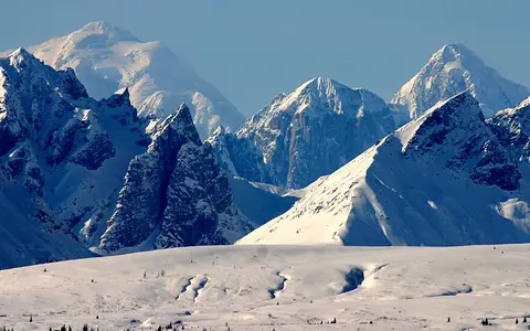
From west to east, the range curves around the northern side of the Cook Inlet–Susitna and Copper River lowlands. The highest ground is in the central massif around Mount McKinley and Mount Foraker, within Denali National Park and Preserve; eastward, the mountain axis continues through the eastern Alaska Range toward the Alaska–Yukon boundary. The Alaska Range is not the Alaska Peninsula, the Aleutian Range, Denali National Park, or the much broader Alaska–Aleutian mountain system, although geographic and geologic descriptions sometimes discuss those adjoining regions together.
A 6,190-metre central summit
Mount McKinley is the highest summit in the Alaska Range and in North America. A June 2015 summit survey using geodetic GPS established an elevation of 20,310 feet (6,190 metres) above mean sea level; the calculation accounted for snow depth and the geodetic surface used to represent mean sea level. This superseded the older 20,320-foot map value and should not be combined with the less precise 2013 airborne-radar estimate. (USGS, 2015 summit survey)
The massif is unusually prominent even within the range. A 2024 study reports that the summit stands about 3,000 metres above most surrounding peaks and occupies a 19° restraining bend in the Denali fault. Mount Foraker reaches 17,400 feet (5,304 m), while the Wickersham Wall on Mount McKinley's north face rises about 14,000 feet (4,270 m) from Peters Glacier to the North Peak. These are different measurements—summit elevation above sea level versus local face relief—and are not interchangeable. (Matmon and others, 2024; NPS range overview; NPS park statistics)
As of February 2025, Mount McKinley is the official federal name; Denali, derived from the Koyukon name deenaalee, remains its long-established Koyukon-derived and widely used Alaska name. Denali National Park and Preserve did not change its name. Both summit names are included here so the record remains intelligible across federal maps, Alaska usage, and scientific literature. (U.S. Department of the Interior, Secretary's Order 3424; NPS name history)
Accreted crust beside an active strike-slip fault
The range is not made from one folded rock unit. Its bedrock is a mosaic of terranes—fault-bounded crustal fragments with distinct histories—including rocks related to Wrangellia south of the Denali fault, Yukon–Tanana crust to the north, and narrower slivers caught along the suture between them. Sedimentary basin rocks, volcanic units, metamorphic belts, and intrusive bodies were juxtaposed during Mesozoic accretion and later translated along the fault. (Nokleberg and Richter, 2007)
The pale granitic rocks of the central massifs are younger than many of the surrounding terranes. Isotopic work on the McKinley sequence placed its granitic plutons at an average potassium–argon age of 57.3 million years and no older than about 60 million years by rubidium–strontium dating. Those crystallization ages date magma emplacement, not the present mountain relief: rapid rock uplift and exhumation around the central massif developed much later, especially over roughly the past six million years. (Lanphere and Reed, 1985; Matmon and others, 2024)
The Denali fault is primarily dextral, meaning that the opposite side moves to the right when viewed across the fault. Near Mount McKinley, the 2024 study gives a slip rate of about 7 mm per year; at a restraining bend, that horizontal motion also shortens and uplifts crust. Present activity is not inferred from landscape alone. The 3 November 2002 moment-magnitude 7.9 earthquake ruptured about 340 km across the Susitna Glacier, Denali, and Totschunda faults, demonstrating that the range's fault system can move in large, linked events. (Eberhart-Phillips and others, 2003)
Terranes and plutons
Older crustal fragments are stitched and displaced by faults; Paleocene granite forms much of the central high massif.
Right-lateral motion
The Denali fault carries mainly horizontal slip, while bends convert part of that motion into shortening and uplift.
Uneven erosion
Glaciers excavate valleys, but resistant rock and persistent sub-zero conditions slow erosion high on the massif.
Valley glaciers radiating from the central massif
Snowfields feed long valley glaciers on every side of the central massif. Kahiltna Glacier descends southwest and is identified by the NPS as the longest in the range. Two NPS summaries round its mapped length differently—44 and 45 miles—so it is best reported as about 71–72 km (44–45 mi); the current park-statistics page gives 45 miles (72.4 km). Ruth Glacier drains the southeast side, Peters Glacier the northwest, and the Harper–Muldrow system the northeast. Ruth reaches 1,160 m in maximum measured thickness. These figures describe individual glaciers inside Denali National Park, not total ice across the Alaska Range. (NPS glacier overview; NPS park statistics)
Ice excavates cirques and U-shaped troughs, plucks bedrock, and carries sediment into moraines and outwash. Meltwater sorts finer material into broad braided channels below the ice. Erosion is not uniform with altitude: cosmogenic-nuclide measurements published in 2024 produced a rate of 4.6 ± 0.6 mm per thousand years at 5,200 m, compared with basin-wide estimates of 450–896 mm per thousand years from sediment below Kahiltna Glacier. The study attributes this contrast to a combination of resistant, sparsely fractured granite and temperatures that rarely rise above freezing above about 4,000 m, helping the highest relief persist while lower valleys are cut more rapidly. (Matmon and others, 2024)
Glaciers also change on different timescales and for different reasons. Inside Denali National Park and Preserve, mapped glacier cover was 3,468 km² in 2020, 14% less than in 1985. That park-bounded result must not be reported as a range-wide loss. Muldrow Glacier, meanwhile, began a surge in 2021—a short interval of unusually rapid flow arising from glacier dynamics, not evidence that the glacier had reversed the regional climate-driven loss. (NPS, Shrinking Glaciers in Denali)
A divide crossed by headwater networks
The mountain arc encloses and separates several major drainage regions rather than forming one uninterrupted continental divide. On the central south side, meltwater from Kahiltna and Ruth Glaciers enters tributaries of the Susitna River and ultimately Cook Inlet. Farther east, southern and southeastern headwaters reach the Copper River and Gulf of Alaska. North-facing streams enter the Tanana, a major Yukon tributary, while northwestern and western slopes feed the Kuskokwim system; both the Yukon and Kuskokwim discharge to the Bering Sea.
Within Denali National Park, the range separates the Susitna lowlands on the south from the Kuskokwim and Tanana basins on the north. Yet passes, through-going river corridors, and local changes in crest geometry interrupt a simple south-versus-north pattern. Glacial erosion has also reorganized divides and valleys repeatedly. The most accurate atlas description is therefore a network of headwater divides, with outwash plains and braided rivers extending the geomorphic influence of the mountains well beyond exposed bedrock. (NPS ecological and physical overview)
Gulf moisture, altitude, and continental air
The Alaska Range stands between storm tracks and moist air from the Gulf of Alaska and the colder continental interior. Air lifted over the southern flank cools and yields rain or snow; high accumulation zones sustain glaciers even though individual slopes vary with elevation, orientation, and exposure. North of the crest, Denali's lowlands have a more continental regime, with lower precipitation and greater seasonal temperature variation than the transitional maritime climate on the south side. (NPS weather and climate summary)
This contrast should not be reduced to a fixed precipitation figure for the entire range. The NPS notes that the highest summits receive more precipitation and are colder than its instrumented lowlands, but that long, continuous high-elevation records do not exist. Passes channel air across the range, and the western, central, and eastern sectors have different exposure to Gulf, Bering Sea, and interior air masses. Accordingly, lowland station normals are useful for their sites but are not proxies for the range crest.
Where the arc meets adjoining landscapes
The western Alaska Range approaches the mountainous country of the Alaska Peninsula; the central arc stands north of Cook Inlet and the Susitna Lowland; and the eastern range borders the Copper River Basin before reaching the Alaska–Yukon boundary. North of the crest, piedmont slopes descend toward the Tanana–Kuskokwim lowlands. These transitions are gradual, which is why range length depends on the chosen end points and why the page does not assign a single width or coordinate to the feature.
Within the North American Cordillera, the Alaska Range is a comparatively compact, high-latitude arc whose drainage divide is interrupted and whose highest relief is concentrated in one central massif. That differs from the much longer continental system described in the Rocky Mountains record. Return to the Mountain Hub for other range-scale landforms.
Data sources and publications
- U.S. National Park Service. The Alaska Range and Mount McKinley: Geology and Orogeny, updated 31 January 2025. Range extent, relief context, rock types, and glacial landforms.
- U.S. Geological Survey. New Elevation for Nation's Highest Peak, 2 September 2015. GPS summit elevation and measurement notes.
- Matmon, A., and others. Anomalously high relief on Denali, Alaska, caused by tectonic, lithologic, and climatic drivers, Earth and Planetary Science Letters 646 (2024), 118999. Fault slip, relative relief, erosion rates, and high-elevation temperature observations.
- Lanphere, M. A., and Reed, B. L. The McKinley Sequence of granitic rocks, Journal of Geophysical Research 90 (1985). Pluton ages and accretionary setting.
- Nokleberg, W. J., and Richter, D. H. Origin of narrow terranes and adjacent major terranes occurring along the Denali fault, Geological Society of America Special Paper 431 (2007). Terrane framework and fault translation.
- Eberhart-Phillips, D., and others. The 2002 Denali fault earthquake, Alaska, Science 300 (2003), 1113–1118. Moment magnitude and mapped rupture length.
- U.S. National Park Service. Denali National Park and Preserve: Park Statistics, accessed 30 August 2026; and Glaciers / Glacial Features, updated 5 February 2025. Summit and glacier measurements, including the 44–45-mile Kahiltna rounding difference.
- U.S. National Park Service. Shrinking Glaciers in Denali National Park and Preserve, updated 2 February 2025. 1985–2020 glacier-area comparison and the 2021 Muldrow surge.
- U.S. National Park Service. Weather and Climate. Maritime–continental contrast and high-elevation data limitations; accessed 30 August 2026.
- U.S. Department of the Interior. Secretary's Order 3424: Mount McKinley and Landmarks Honoring the Alaskan People, 14 February 2025; and U.S. National Park Service, Naming a Mountain, updated 26 March 2025.