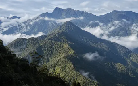
A measured belt, not every mountain on New Guinea
“Central Mountain Range” is the descriptive title used by this atlas. Central Range, central highland chain, New Guinea Highlands, and sometimes Central Cordillera overlap in use but do not always share identical boundaries. This record follows the explicit geographic definition used by Toussaint and colleagues: a belt about 1,300 km long and up to 150 km wide, from the eastern end of the Bird's Head region at about 135°E to about 145°E, where the westernmost Owen Stanley Range begins. (Toussaint and others, 2021)
On that definition, the chain includes the Maoke highlands of western New Guinea, the transboundary Star Mountains, the Bismarck Range and adjoining Papua New Guinea highlands, and the transition into the western Owen Stanley sector. It does not assign the full southeastward length of the Owen Stanley Range or the separate north-coast ranges to the 1,300 km measurement. A single point coordinate would therefore misrepresent this elongated, boundary-dependent feature; the longitude limits above are more useful than an invented centroid.
Massifs above a two-to-three-kilometre highland province
The range is not a continuous crest. Regional work describes more than 20 summits above 4,000 m, while a tectonic synthesis characterizes much of the New Guinea Highlands province as averaging roughly 2–3 km elevation. The highest reported summit is Puncak Jaya, 4,884 m above sea level, in the Sudirman Mountains of the western Maoke sector. (Toussaint and others, 2021; Knight and others, 2022; Ibel and others, 2025)
High limestone and metamorphic massifs alternate with dissected plateaus, fault-guided valleys, and enclosed or partly enclosed basins. The Baliem Valley in western New Guinea and the Wahgi Valley farther east are examples of broad intermontane floors surrounded by higher ridges. These basins interrupt the axial divide, store slope and river sediment, and funnel their outflow through narrower valleys and gorges. The result is a wide mountain province rather than one ridge line that can be followed continuously on a map.
Puncak Jaya
The 4,884 m figure is a reported summit elevation, not a measurement of the changing ice surface nearby.
Parallel belts and massifs
Folded sedimentary rocks, metamorphic belts, and uplifted oceanic rocks create distinct ridges across the range.
Basins within mountains
Elevated valley floors separate high blocks and redirect drainage along and across the structural grain.
Australian-margin rocks beneath accreted oceanic belts
The southern part of the range is built largely from sedimentary rocks deposited on the former northern margin of the Australian continent. Compression shortened these layers into a fold-and-thrust belt: a zone where strata are folded and stacked along low-angle faults. Farther north are metamorphic rocks, volcanic-arc rocks, and ophiolites. An ophiolite is a slice of oceanic crust and upper mantle tectonically emplaced on land. These contrasting belts are why “fold mountain” alone is an incomplete classification. (Davies, 2012; Knight and others, 2022)
In the western Central Range, researchers distinguish the Irian fold-and-thrust belt, the Ruffaer metamorphic belt, and the Irian Jaya ophiolite with associated arc rocks. Their boundaries and exhumation histories vary along the chain. The present plate boundary is also divided among faults and smaller crustal blocks, so local uplift, strike-slip motion, and extension cannot be reduced to motion on one simple Australia–Pacific fault. (Martin and others, 2023; Davies, 2012)
Uplift occurred in stages, not on one date
Geological syntheses place the start of widespread central New Guinea collision and crustal shortening in the mid-Miocene, when Australian continental crust reached the collision zone, approximately 15–12 million years ago. New thermochronology and structural reconstruction from the western range indicate especially rapid uplift and denudation between about 10 and 6 million years ago. Those figures refer to regional cooling, unroofing, and modeled erosion—not the age of every ridge or valley. (Knight and others, 2022; Martin and others, 2023)
Uplift and erosion then continued unevenly from west to east. Thrusting raised the southern flank, faults displaced blocks along the belt, and rivers and landslides removed rock as relief increased. Rapid erosion exposed metamorphic and ophiolitic rocks and delivered thick clastic sediment to the Mamberamo–Meervlakte depression north of the western range and to the southern foreland. The range is therefore an active, evolving orogen—an actively deforming mountain belt—not a relic of one finished collision.
Steep headwaters, low-gradient receiving plains
The axial highlands form a major but locally irregular drainage divide. In the west, northern headwaters descend toward the Mamberamo lowland basin; farther east, the Sepik and Ramu systems receive runoff from the Papua New Guinea highlands. South-facing catchments feed the Fly and Purari systems. Intermontane basins and valleys running along the structural grain mean that the drainage boundary does not everywhere coincide with the highest summit line. (Davies, 2012; Papua New Guinea Department of Foreign Affairs)
Channel character changes sharply downstream. Short, steep mountain reaches cut gorges and move coarse sediment; after leaving the highlands, major rivers meander across much flatter floodplains. Papua New Guinea's government overview identifies high sediment loads in the Sepik, Ramu, Fly, and Purari systems and links that sediment to extensive swampy plains and deltas. This export is part of the range's physical geography: erosion of the highlands builds landforms far beyond the mountain front.
Exposure and elevation matter as much as latitude
Equatorial warmth and moisture provide the regional setting, but the range redistributes both. Southeast trade winds, northwesterly monsoonal flow, convection, and local upslope circulations lift moist air over the flanks. Papua New Guinea's government climate overview reports roughly 2,500–4,000 mm of annual rainfall across its Highlands, generally with a drier midyear phase, while exposed south-facing slopes can receive much more. These are regional ranges, not a value for the entire 1,300 km chain. (Papua New Guinea Department of Foreign Affairs)
Air temperature decreases with height, allowing frost in high valleys and cold summit conditions only a few degrees from the equator. Ridges force ascent and rain, whereas enclosed basins may be partly sheltered; cloud, slope aspect, and time of day further change local conditions. Around Puncak Jaya, the 2025 glacier survey cites 2,500–4,500 mm per year and influence from both the El Niño–Southern Oscillation and the South Pacific Convergence Zone. That western summit-area estimate should not be transferred unchanged to the eastern highlands. (Ibel and others, 2025)
A large former footprint and two small 2024 remnants
Cold-stage glaciers once occupied high plateaus and valleys across several western and central massifs. A recent review cites earlier reconstructions estimating 2,000–2,200 km² of ice across New Guinea's high mountains at the Last Glacial Maximum, including about 863 km² in the Puncak Jaya area. These are reconstructed past extents, not modern mapped surfaces. Cirques, troughs, moraines, and glacially excavated basins remain after most of that ice disappeared. (Ibel and others, 2025)
Modern glacier ice is restricted to the Puncak Jaya area of the Sudirman Mountains. Manual mapping from 2023–2024 PlanetScope and Pléiades imagery found two remaining ice bodies—the fragmented East Northwall Firn and Carstensz Glacier—with a combined 2024 area of 0.165 km² ± 5%. The same study found about a 65% decrease since 2018. Date, method, and uncertainty are essential here: this area measures glacier surface on selected imagery, not snow cover, ice volume, or the area of the wider mountain range.
Mountain fronts tied to forelands and coastal basins
North of the axial belt, the Mamberamo–Meervlakte and Sepik lowlands separate much of the Central Range from distinct north-coast mountain systems. Southward, folded foothills descend into the New Guinea foreland and broad Fly–Gulf of Papua plains developed on the Australian continental margin. At the western end the belt approaches the structurally different Bird's Head region; at the eastern limit used here it meets, but does not absorb the full length of, the Owen Stanley Range.
These transitions show why the feature is best understood as a compound orogen linked by structure and topography, not as a single crest or an administrative “Highlands” region. Use the Mountain Hub for other major mountain systems and the Rwenzori Mountains for a separate equatorial range with surviving evidence of much larger former glaciers.
Data sources and publications
- Toussaint, E. F. A., White, L. T., Shaverdo, H., and others. “New Guinean orogenic dynamics and biota evolution revealed using a custom geospatial analysis pipeline,” BMC Ecology and Evolution 21, 51 (2021). Explicit Central Range name, approximately 1,300 km length, up-to-150 km width, 135°E–145°E scope, constituent sectors, and summit-count context.
- Knight, L., Copley, A., Bertoni, C., Sloan, R. A., and Walker, R. “Links between foreland rheology and the growth and evolution of a young mountain belt in New Guinea,” Geophysical Journal International 228 (2022), 1684–1712. Active tectonics, Australian-margin setting, mid-Miocene collision, regional elevation, and along-strike variation.
- Davies, H. L. “The geology of New Guinea—the cordilleran margin of the Australian continent,” Episodes 35, no. 1 (2012), 87–102. Fold-and-thrust structure, accreted terranes, ophiolites, foreland and Mamberamo basin relationships, and complex modern plate boundary.
- Martin, P. E., Macdonald, F. A., McQuarrie, N., Flowers, R. M., and Maffre, P. J. Y. “The rise of New Guinea and the fall of Neogene global temperatures,” Proceedings of the National Academy of Sciences 120, no. 40 (2023), e2306492120. Western Central Range lithotectonic belts, thermochronology, modeled erosion, and rapid 10–6 Ma uplift and denudation.
- Papua New Guinea Department of Foreign Affairs. Climate of PNG (accessed 30 August 2026). Highlands rainfall range, wind systems, exposure, elevation, and temperature controls.
- Papua New Guinea Department of Foreign Affairs. Drainage and Soils (accessed 30 August 2026). Highland river gradients, sediment loads, downstream floodplains, swamps, and deltas in the Sepik, Ramu, Fly, and Purari systems.
- Ibel, D., Mölg, T., and Sommer, C. “Brief communication: Tropical glaciers on Puncak Jaya (Irian Jaya/West Papua, Indonesia) close to extinction,” The Cryosphere 19 (2025), 6629–6637. Puncak Jaya elevation as reported, regional precipitation context, reconstructed former ice, and 2024 glacier area derived from PlanetScope and Pléiades imagery.