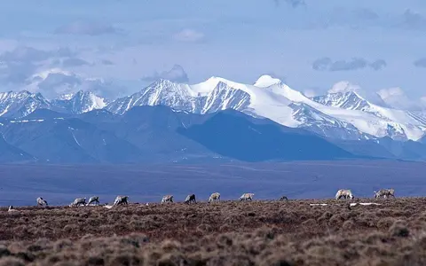

Which mountain belt this record covers
Brooks Range is the federal standard name for the Alaskan mountainland. The U.S. Board on Geographic Names adopted it in 1925; older mapped variants included Arctic Mountains, Hooper Mountains, Meade Mountains, Meade River Mountains, and Rocky Mountains. Those names document earlier usage but are not equivalent current names. The range was named for USGS geologist Alfred Hulse Brooks. (USGS, Dictionary of Alaska Place Names)
This page uses the Alaskan scope recorded by the USGS: about 600 miles (970 km) long and 80 miles (130 km) wide, from the Chukchi Sea side of Alaska east to the Canadian boundary. The 1967 gazetteer placed descriptive end points near 68° N, 163° W and 69° N, 141° W. They orient the range; they do not define a legal boundary or a geometric centre. The Brooks Range is also distinct from the much larger North Slope watershed, the Arctic Foothills to its north, and the protected areas that cover only parts of it. (USGS, Physiographic Divisions of Alaska)
The current GNIS record classifies Brooks Range as a range and stores 69°12′08″ N, 143°48′06″ W (69.202222, −143.801667) as its primary coordinate. GNIS places a range coordinate at its highest point, so this marks Mount Isto rather than the range's centre or boundary; it should not be used to calculate the range's extent. (GNIS feature 1847199; USGS GNIS coordinate guidance)
The belt is a chain of linked mountain groups rather than a single crest. From west to east these include the De Long, Baird, Schwatka, Endicott, Philip Smith, Franklin, and Romanzof mountains. The USGS classifies the Brooks Range within Alaska's Rocky Mountain System, itself part of the North American Cordillera. Across the international boundary, adjoining Yukon mountain belts are mapped under other names; they are outside this page's 600-mile measurement.
Lower western ridges and a 2,735.6-metre eastern summit
Relief generally increases eastward. Broad, subdued uplands and dissected ridges dominate much of the western range, while limestone ridges and granitic massifs rise above deeply cut valleys in the central and eastern sectors. In Gates of the Arctic, southern foothills rise through roughly 1,200-m (4,000-ft) ridges to limestone and granite peaks above 2,130 m (7,000 ft); those park figures describe the central range, not every summit. (NPS Arctic Inventory and Monitoring Network)
Mount Isto in the Romanzof Mountains is the measured high point. Airborne structure-from-motion photogrammetry acquired in 2014 and checked against summit GPS and lidar gave 2,735.6 m (8,975.1 ft), referenced to the NAVD88 GEOID12A vertical datum, with validation uncertainty better than ±0.20 m at 95% RMSE. The same survey measured Mount Hubley at 2,717.6 m and Mount Chamberlin at 2,712.3 m. This resolves the contradiction in 1950s USGS maps, which alternated between Isto and Chamberlin and listed elevations as high as 9,050 ft. Because glacier ice covers these summits, small surface-height changes are possible; the 2014 observation is not a timeless bedrock elevation. (Nolan and DesLauriers, 2016)
Two superposed episodes of crustal shortening
The Brooks Range is a north-directed fold-and-thrust belt: rock layers were folded and slices of crust were carried northward over one another along low-angle faults. Regional mapping shows a varied stack of Paleozoic and Mesozoic sedimentary rocks, metamorphic rocks, and oceanic and igneous units rather than one uniform limestone range. The central Arrigetch Peaks, for example, are granite exposed within a surrounding schist belt, while much of central Gates of the Arctic is underlain by marine sedimentary rocks of the Endicott Group. (USGS geologic map; NPS central-range geology)
USGS structural synthesis separates two main contractional episodes. Arc–continent collision from about 160 to 120 million years ago produced far-travelled, relatively thin thrust sheets. Renewed shortening at about 60 million years ago, with reactivation near 45 million years ago, folded a thicker structural section and helped generate the modern high-relief belt and northern foothills. A single formation date would therefore confuse one event within a long, multi-stage history with the age of the present landscape. (Moore and others, 2004)
Erosion translates that structure into terrain. Resistant limestone and granite commonly support cliffs and narrow crests; shale-rich units more readily underlie gentler slopes and valleys. Glacial excavation, river incision, rockfall, frost cracking, and slow downslope movement of seasonally thawed soil continue to cut across or soften the east–west structural grain.
Thin-skinned thrusting
Cover rocks moved along shallow detachments without every fault cutting through the full crust.
Folded foothills
Buried thrust sheets and younger folds continue north of the high mountain front.
Ridges and troughs
Rock strength, former ice flow, streams, and frost processes create strongly unequal relief.
Large inherited troughs, small surviving glaciers
Pleistocene ice occupied much of the central and eastern range and cut cirques, U-shaped valleys, rock basins, and cross-range troughs. Moraines mark former ice margins, while outwash spreads gravel beyond them. Modern ice is far less extensive and is concentrated in high, sheltered cirques and valleys, especially around the eastern massifs; perennial snowfields are not glaciers because they persist but do not become thick enough to flow.
A geodetic study of 107 central Brooks Range glaciers—42 km² of ice in 1970/1973—compared reconstructed historical-map elevation models with a 2001 radar-derived model. It found a total volume loss of 0.69 ± 0.06 km³ and an area-weighted balance of −0.54 ± 0.05 m water equivalent per year over 1970–2001. “Water equivalent” expresses the lost ice mass as an equivalent depth of liquid water. These results cover a central-range sample, not all Brooks Range ice; the study also found that glacier geometry affected the rate of loss. (Geck, Hock, and Nolan, 2013)
Change also affects non-flowing snow. Landsat mapping within Gates of the Arctic National Park and Preserve found that total perennial-snowfield area decreased between 1985 and 2017, with much of the change late in the record and remaining fields occurring at progressively higher elevations. Again, this is a park-bounded central-range result. Beyond the ice, widespread permafrost limits subsurface drainage; its summer-thawed active layer can saturate, accelerate runoff, and support frost-related slope movement. (Tedesche and others, 2019; NPS Arctic permafrost overview)
A divide with different routes to two oceans
Near the crest, drainage separates into several systems rather than one simple north–south split. North-flowing rivers descend across the Arctic Foothills and North Slope to the Chukchi or Beaufort seas; some join the Colville, while others cross the coastal plain independently. On the south side, the Koyukuk and Chandalar systems enter the Yukon River and eventually the Bering Sea. In the western and central range, the Kobuk and Noatak flow west toward Kotzebue Sound and the Chukchi Sea. (NPS drainage overview)
The divide is topographically asymmetric. The USGS places it near the north edge of the mountain belt in places and records wind gaps, abandoned valleys, and stream capture—the diversion of headwaters by an eroding neighboring stream—as evidence that it has migrated. Rivers emerging northward from the mountains become braided across broad gravel flats. Winter overflow can freeze in repeated sheets to form aufeis, which persists into summer and temporarily stores water outside glacier ice. (USGS physiographic description)
Runoff is sharply seasonal. Snowmelt and river-ice breakup produce the principal spring-to-early-summer pulse; rain can raise small mountain rivers rapidly later in summer, and glacier melt matters most in the relatively few glacierized headwaters. Permafrost and shallow active layers restrict infiltration over much of the tundra terrain, promoting quick surface response, but local bedrock fractures, taliks—unfrozen zones within permafrost—and gravel aquifers prevent the range from behaving as a uniformly sealed surface.
Arctic exposure, continental air, and valley inversions
The range stands between the Arctic coastal plain and the continental interior, but it does not create one uniform climate boundary. In the central Brooks Range, the NPS classifies the north side above timberline as Arctic and the lower south side as subarctic. Elevation, slope aspect, and wind redistribute snow; passes channel air across the divide, and cold-air inversions can make valley floors colder than slopes above them. (NPS Gates of the Arctic weather summary)
NPS planning guidance gives broad annual precipitation estimates of about 5–10 in (127–254 mm) on the north side and 8–18 in (203–457 mm) on the south side within Gates of the Arctic. Those figures are regional generalizations rather than gridded normals for the whole 970-km range, and they should not be assigned to Mount Isto or another summit. The geographic pattern matters more: limited moisture constrains glacier accumulation, sheltered high basins preserve snow, and strong temperature inversions complicate a simple cooling-with-elevation rule.
From Chukchi lowlands to the Canadian boundary
At the western end, the De Long and Baird mountains break down toward Chukchi coastal lowlands and the basins around Kotzebue Sound. The central Schwatka and Endicott mountains enclose headwaters of the Noatak, Kobuk, Koyukuk, and Colville systems. Farther east, the Philip Smith, Franklin, and Romanzof mountains rise between the Yukon interior and the Beaufort coastal plain before the Alaskan name reaches the international boundary.
North of the high range, the Arctic Foothills form a separate rolling physiographic province before the land descends to the coastal plain. Southward, mountain valleys open into the Kobuk, Koyukuk, Chandalar, and Porcupine–Yukon country. These gradual transitions explain why length and width are rounded and why a single coordinate cannot represent the range. Return to the Mountain Hub, or compare this Arctic fold-and-thrust belt with the taller, strongly glaciated Alaska Range farther south.
Data sources and publications
- Orth, D. J. Dictionary of Alaska Place Names. U.S. Geological Survey Professional Paper 567, 1967. Standard name, historical variants, descriptive endpoints, and naming history.
- U.S. Geological Survey and Alaska Department of Fish and Game. Geographic Names Information System: Brooks Range, feature 1847199; and USGS, What is the Geographic Names Information System?. Feature class, primary coordinate, and coordinate convention; accessed 30 August 2026.
- Wahrhaftig, C. Physiographic Divisions of Alaska. U.S. Geological Survey Professional Paper 482, 1965. Range dimensions, physiographic classification, relief, foothills, drainage-divide position, braided channels, and aufeis.
- Nolan, M., and DesLauriers, K. Which are the highest peaks in the US Arctic? Fodar settles the debate. The Cryosphere 10 (2016), 1245–1257. 2014 peak elevations, vertical datum, validation, uncertainty, and older-map discrepancy.
- Moore, T. E., Potter, C. J., O'Sullivan, P., Shelton, K. L., and Underwood, M. B. Two stages of deformation and fluid migration in the west-central Brooks Range fold and thrust belt, Northern Alaska, 2004. Timing and mechanics of the superposed contractional belts.
- Grybeck, D. J., Beikman, H. M., Brosgé, W. P., Tailleur, I. L., and Mull, C. G. Geologic Map of the Brooks Range, Alaska. U.S. Geological Survey Open-File Report 77-166-B, 1977, scale 1:1,000,000. Regional rock units and named mountain groups.
- U.S. National Park Service. Geology: Gates of the Arctic National Park and Preserve, updated 4 April 2023; and Gates of the Arctic National Park and Preserve, updated 2 February 2022. Central-range rock, relief, glaciation, and drainage context.
- Geck, J., Hock, R., and Nolan, M. Geodetic Mass Balance of Glaciers in the Central Brooks Range, Alaska, U.S.A., from 1970 to 2001. Arctic, Antarctic, and Alpine Research 45 (2013), 29–38. Sample area, methods, volume change, mass balance, and uncertainty.
- Tedesche, M. E., Trochim, E. D., Fassnacht, S. R., and Wolken, G. J. Extent Changes in the Perennial Snowfields of Gates of the Arctic National Park and Preserve, Alaska. Hydrology 6 (2019), 53. Landsat analysis for 1985–2017.
- U.S. National Park Service. Weather: Gates of the Arctic National Park and Preserve; and Arctic Nature and Science. Climate classification, precipitation generalizations, inversions, active-layer hydrology, and permafrost processes; accessed 30 August 2026.