A named range with conventional ends
Apennines and Apennine Mountains are the accepted English forms; Italian uses Appennino or Appennini. This page covers the mainland chain from the conventional Alpine–Apennine boundary at Colle di Cadibona, also called Bocchetta di Altare, to the mountains of Calabria beside the Strait of Messina. Treccani gives this route an approximate length of 1,350 km and describes the northern division from the Alps as conventional rather than a sharp natural break. (Treccani)
Northern Sicily's Peloritani, Nebrodi, and Madonie are sometimes grouped as the Sicilian Apennines. Those island sectors are not included in the 1,350 km mainland figure used here. Because foothills merge into foreland deposits and the range follows an arc, a single centre coordinate or straight endpoint distance would misrepresent its position and extent.
From the Po foreland to the Calabrian Arc
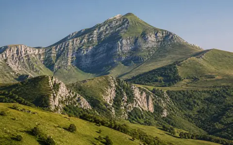
From Cadibona the Northern Apennines curve through Liguria and the Tuscan–Emilian sector. Their northeastern front descends beneath the southern margin of the Po Basin, while short Ligurian catchments fall steeply toward the sea. The Central Apennines begin conventionally near the upper Tiber–Metauro divide and contain the chain's greatest relief: the Sibillini, Gran Sasso, and Maiella massifs are separated by transverse valleys and broad intermontane basins such as L'Aquila, Fucino, and Sulmona. (Treccani)
South of the central massifs, relief becomes more segmented through the Matese, Campanian, Lucanian, and Pollino groups. Calabria is a marked transition rather than simply another limestone ridge: Sila, Serre, and Aspromonte are underlain largely by older plutonic and metamorphic rocks and stand between narrow Tyrrhenian and Ionian margins. The national park authority publishes 2,912 m for Corno Grande, while Treccani's older profile lists 2,914 m. Neither source states a survey method or vertical datum, so this page uses the park authority's current topographic value but does not interpret the two-metre difference as measured summit change. (Gran Sasso–Monti della Laga National Park; Treccani; D'Agostino, Dramis, and Molin, 2002)
Accretion, rollback, and a migrating foredeep
The range is a fold-and-thrust belt assembled mainly from sedimentary successions deposited on former Tethyan oceanic and continental margins. As subduction consumed lithosphere beneath the western side of the belt, layers were shortened, folded, and detached into stacked thrust sheets. Deformation and the adjacent foredeep—a subsiding basin produced by the load of the growing mountains—migrated generally east and northeast toward the Adriatic–Apulian foreland from the late Oligocene through the Neogene. (Carminati and Doglioni, 2012; Treccani)
Retreat of the subduction hinge also stretched the overriding region and opened the Tyrrhenian back-arc basin. This paired history explains compression at the outer front and extension farther west and along the modern chain axis. It also explains why “fold mountains” is an incomplete label: thrust stacking built the belt, but normal faulting, uplift, river incision, and slope erosion have strongly modified its present relief. (Carminati and Doglioni, 2012; ISPRA Geological Field Trips, 2022)
Deep-water sediments
Sandstone–marl turbidite successions and clay-rich units form long ridges and erosion-prone slopes; “flysch” describes these repeated deep-water deposits, not one rock type.
Carbonate massifs
Thick limestone and dolostone successions form high blocks, scarps, gorges, caves, dolines, and large aquifers.
Older crystalline rocks
Plutonic and metamorphic massifs give the Calabrian end a different lithology and upland form from the central carbonate chain.
Normal faults continue to widen the chain
Present deformation is not uniform along the arc. A 2025 INGV synthesis of dense Global Navigation Satellite System measurements reports 2–3 mm per year of southwest–northeast extension accommodated by normal faults along the chain axis. This is a network-scale velocity estimate, not the annual slip of every mapped fault. Earthquakes release part of that accumulated strain, while some deformation may be aseismic. (INGV Bologna, 2025 research summary)
Repeated motion on normal faults lowers basin floors relative to adjoining ridges. In the central Apennines, this process produced basins that accumulated lake, river, alluvial-fan, and slope deposits through the Quaternary. The L'Aquila, Rieti, Fucino, Sulmona, and other interior basins are therefore structural depressions within the mountain belt, not simply valleys carved between unchanging ridges. (APAT field guide, 2002; INGV, 2016)
Surface divides and underground catchments
Drainage is asymmetric because the main divide is commonly farther from the Tyrrhenian coast than from the Adriatic. The Arno and Tiber headwaters drain westward through relatively large basins; the Nera and Aniene join the Tiber, and the Liri–Garigliano and Volturno also reach the Tyrrhenian. The Reno, Metauro, Tronto, Aterno–Pescara, and Sangro cross the eastern side toward the Adriatic, while Northern Apennine tributaries feed the Po. In the far south, short streams descend toward both the Tyrrhenian and Ionian seas. (Treccani)
Carbonate sectors do not obey surface topography alone. Rain and snowmelt enter joints, faults, sinkholes, and closed depressions, then move through fractured and karstified limestone until low-permeability units or basin margins force the water back to the surface. At the Cassino basin, a 2019 hydrogeological synthesis compiled 13–18 m³/s for the Gari springs and about 5 m³/s for the Peccia springs from earlier discharge records. The authors also document competing models of the contributing hydrostructures, so these figures are a bounded central-southern example—not a current range-wide flow total or timeless spring rate. (Saroli, Lancia, and Petitta, 2019)
Cold-stage ice overprints soluble rock
High Apennine terrain preserves cirques, moraine ridges, rock glaciers, and glacially modified basins from the Pleistocene. A reconstruction based on mapped landforms and cosmogenic 10Be exposure ages identified more than 100 valley and mountain glaciers in the Northern Apennines, together covering more than 260 km² at their local last-glacial maximum; the oldest moraine ages place that maximum before about 21,000 years ago. These are reconstructed past extents, not modern ice inventory figures. (Baroni and others, 2018)
In the central carbonate massifs, glacial and karst processes overlap. Campo Imperatore is a tectonic basin with alluvial plains, moraines, cirques, and periglacial deposits, while dissolution routes much of its water underground. Nearby Gran Sasso contrasts with the less permeable sandstone–marl Monti della Laga, where streams and waterfalls remain more prominent at the surface. This local contrast shows why one drainage or landform model cannot be applied to the whole range. (Gran Sasso–Monti della Laga National Park, Campo Imperatore; park geology and morphology profile)
Exposure changes with each circulation pattern
Latitude, elevation, distance from the sea, slope aspect, and basin shelter all matter. Lower slopes have Mediterranean seasonality, while high central ridges are colder and retain winter snow longer. A permanent “wet west, dry east” division is misleading: moist southwesterly flow favors the Tyrrhenian side and western slopes, but northeasterly or southeasterly flow from the Adriatic reverses the exposure pattern.
A 2022 central-Italy study combining rain gauges with ERA5 circulation fields for 1951–2019 attributed about 45% of annual precipitation to southwesterly and westerly cyclonic types and about 30% to northeasterly and southeasterly cyclonic types. Those percentages describe the study region and classification, not the entire 1,350 km chain. They nevertheless show why individual storms can produce a rain shadow on either side and why local relief cannot be represented by one range-wide rainfall value. (Silvestri, Saraceni, and Bongioannini Cerlini, 2022)
A divide that also exports water and sediment
Northward, buried Apennine thrusts extend beneath the Po foreland and approach structures associated with the Alps. Eastward, streams carry eroded sandstone, marl, limestone, and basin fill across foothills to the Adriatic and into the Po system. Westward, the range overlooks faulted basins and volcanic districts created within the wider Tyrrhenian extensional region. At the southern end, the Calabrian Arc narrows between the Tyrrhenian and Ionian margins before the structural system continues across the Strait of Messina. (D'Agostino, Dramis, and Molin, 2002; Carminati and Doglioni, 2012)
These links make the Apennines both a barrier and a transfer zone. Topographic divides separate surface basins, but faults and karst connect underground water; uplift creates relief, while rivers and mass movement remove it; and the range front supplies sediment to adjoining forelands. Compare this system through the mountain hub, the Alps record, and the Po River record.
Data sources and publications
- Treccani. Appennino (accessed 30 August 2026). Italian names, conventional Alpine boundary, approximately 1,350 km mainland extent, regional divisions, relief, climate, and drainage orientation.
- Ente Parco Nazionale del Gran Sasso e Monti della Laga. Territorio e Natura, L'Altopiano di Campo Imperatore, and L'area interessata dal progetto (accessed 30 August 2026). Corno Grande's published 2,912 m elevation; Gran Sasso, Campo Imperatore, and Monti della Laga lithology, drainage, and glacial landforms.
- Carminati, E., and Doglioni, C. “Alps vs. Apennines: The paradigm of a tectonically asymmetric Earth,” Earth-Science Reviews 112 (2012), 67–96. Tethyan margins, Apennine accretion, subduction-hinge retreat, and Tyrrhenian back-arc extension.
- D'Agostino, N., Dramis, F., and Molin, P. “Geological and tectonic setting of the Apennines and the Calabrian Arc,” in Seismically Induced Ground Ruptures and Large Scale Mass Movements, APAT Atti 4/2002 (printed December 2002), pp. 1–12. Migrating compression and extension, Quaternary basins, uplift, drainage, and Calabrian crystalline rocks.
- ISPRA Geological Survey of Italy. The Tethyan and Tyrrhenian Margin Record of the Central Apennines, Geological Field Trips and Maps 14 (2.2), DOI 10.3301/GFT.2022.05 (2022). Carbonate platforms, Neogene compression, Quaternary extension, and Gran Sasso hydrogeology.
- Nucci, R., Serpelloni, E., Faenza, L., Garcia, A., and Belardinelli, M. E. “Geodetic strain rates and seismicity rates along the Apennines (Italy),” INGV Bologna research summary (2025; page updated 9 February 2026). GNSS-derived 2–3 mm/yr southwest–northeast extension and its relationship to normal faults and seismicity.
- Saroli, M., Lancia, M., and Petitta, M. “The geology and hydrogeology of the Cassino plain (central Apennines, Italy): redefining the regional groundwater balance,” Hydrogeology Journal 27 (2019), 1563–1579. Karst hydrostructures, groundwater-flow uncertainty, and compiled Gari and Peccia spring discharge figures.
- Baroni, C., Guidobaldi, G., Salvatore, M. C., Christl, M., and Ivy-Ochs, S. “Last glacial maximum glaciers in the Northern Apennines reflect primarily the influence of southerly storm-tracks in the western Mediterranean,” Quaternary Science Reviews 197 (2018), 352–367. Reconstructed glacier count, area, equilibrium-line elevations, and 10Be chronology.
- Silvestri, L., Saraceni, M., and Bongioannini Cerlini, P. “Links between precipitation, circulation weather types and orography in central Italy,” International Journal of Climatology 42 (2022), 5807–5825. Rain-gauge and 1951–2019 ERA5 analysis of circulation-dependent precipitation and opposing Apennine rain shadows.
- INGV. The Seismic Sequence in Central Italy: A First Interpretative Framework, 30 August 2016. Normal-fault displacement and the long-term formation of intermontane valleys.