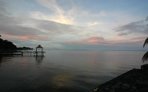

One Nicaraguan lake, several names
The U.S. Board on Geographic Names/National Geospatial-Intelligence Agency record designates the feature as a lake and lists Lago de Nicaragua as the approved name, with Lake of Nicaragua, Gran Lago de Nicaragua, Lago de Granada, and Lago Cocibolca among its variants. Its coordinate, 11°41′14″N, 85°28′43″W, is suitable for locating the feature; a point cannot define a lake extending about 160 km.[1]
The current World Lake Database gives a surface area of 8,150 km² and volume of 108 km³. An earlier ILEC basin brief rounded the surface to 8,000 km² at a lake level of 31.40 m and the volume to 104 km³. Neither source identifies a common shoreline date or outline method, so this record uses “about 8,150 km²” and does not interpret the difference as documented expansion or contraction. [2][3]
Close to the Pacific, draining to the Caribbean
The long axis runs northwest from the Tipitapa lowland toward San Carlos at the southeastern corner. Granada stands on the northwestern shore; Ometepe occupies the western-central lake; the Solentiname archipelago lies near the southern end. The Isthmus of Rivas and the active volcanic front border the west, while uplands in Boaco and Chontales feed rivers from the north and east. The San Juan begins at San Carlos and crosses the Caribbean lowlands.[3]
The water surface is wholly in Nicaragua, but its drainage is not. ILEC divides the larger 41,600 km² Cocibolca–San Juan system into the Lake Managua basin, Lake Cocibolca basin, and lower San Juan basin. The 23,844 km² Cocibolca component includes the lake and surrounding catchment; 4,151 km² lies in Costa Rica, chiefly in southern tributary basins. Subtracting the approximately 8,000 km² water surface leaves roughly 15,800 km² of land draining directly toward the lake. These nested areas are not interchangeable “lake basin” measurements.[3]
An intra-arc half-graben, not a volcanic crater
Lake Nicaragua and Lake Managua occupy a trench-parallel half-graben—an asymmetric basin in which a crustal block has dropped along major faults. A 2023 geological synthesis places development of this depression during or before the Pliocene and relates it to subduction-driven deformation along the Central American margin. The basin is therefore tectonic in origin; it is not a caldera or a lake excavated by one eruption.[4]
Volcanism nevertheless modified the basin. As the volcanic front migrated westward, it came to cross the Nicaraguan Depression, making the lake an intra-arc basin—one lying within a volcanic arc. Tephra, lava, flank-collapse debris, river sediment, and lake mud have progressively filled the structural low. Geophysical interpretations cited by the 2023 synthesis suggest hundreds of metres of Quaternary sediment above still older Pliocene fill, far thicker than the modern water column. [4]
Shallow water with steep volcanic interruptions
Mean depth is consistently reported at approximately 13 m, shallow relative to the lake's 8,000-plus km² surface. Maximum depth is much less secure. The 2003 ILEC brief gives approximately 45 m, while the present IAGLR large-lakes profile, drawing on the World Lake Database, retains 70 m. Because these compilations do not document comparable soundings, survey dates, or vertical datums, this page does not promote either value as a resolved modern maximum. The former 26 m statement has been removed. [2][3]
Ometepe is the clearest contrast between shallow basin and high relief. Concepción and Maderas form opposite ends of the dumbbell-shaped island; Maderas reaches 1,394 m above sea level and its deeply cut ravines record long erosion, while Concepción is the younger, more active cone. Near Granada, Las Isletas are hummocks of a debris avalanche from the northeast flank of Mombacho. The same collapse deposit built the arcuate Aseses Peninsula and continues below the water surface. [6][7]
Nicaraguan Depression
A northwest–southeast half-graben containing thick lake and volcanic sediment.
Ometepe volcanoes
Concepción and Maderas rise abruptly from the western-central lake floor.
Collapse-built islets
Las Isletas and Aseses Peninsula are exposed parts of Mombacho debris.
Many inflows, one dependable surface outlet
Tributaries enter around the basin rather than through one dominant river. CIRA/UNAN sampling names the Malacatoya, Mayales, Acoyapa, Oyate, and Tepenaguasapa on the northern and eastern sides and the Ochomogo from the southwest; the ILEC basin map also shows the Tule and Costa Rican Frío system. These rivers build local deltas and deliver sediment and dissolved material from catchments with different rainfall and relief.[3][5]
The Tipitapa River occupies the low corridor between Lake Managua (Xolotlán) and Lake Nicaragua, but the connection is threshold-dependent. The ILEC account says Tipitapa was regularly flowing until the mid-nineteenth century but discharged only a few times during the twentieth century, including after Hurricane Mitch in October 1998. It is an occasional overflow route, not a normal major tributary. [3]
At San Carlos, water leaves through the San Juan River and ultimately reaches the Caribbean Sea. ILEC reproduces an older, undated 40-year-average budget in cubic metres per second: 401 from precipitation directly on the lake, 268 from rivers, 196 from groundwater, and 5 as seepage from Lake Managua, balanced by 399 of calculated evaporation and 476.6 of San Juan outflow. The rounded totals do not close exactly, and the source gives no averaging years, so these figures describe scale and relative importance—not present-day discharge.[3]
A rainfall gradient over a polymictic lake
Moisture increases toward the Caribbean-facing southeast. The ILEC brief reports mean annual precipitation near 1,200 mm at Malacatoya in the northwest and about 4,000 mm in the upper Río Frío catchment in Costa Rica. This gradient helps explain strong southeastern runoff despite the lake's drier Pacific-side setting. Direct rain and evaporation over the broad lake are each comparable in scale to the compiled San Juan outflow, so lake level cannot be understood from tributaries alone. [3]
CIRA/UNAN classifies Cocibolca as polymictic: its water column mixes repeatedly rather than maintaining one stable seasonal thermocline. Mean depth of about 13 m, year-round warm water, and wind over the long open fetch keep much of the lake turbulent and can resuspend surface sediment. Temporary stratification can still occur in deeper or sheltered sectors when winds weaken, so “polymictic” does not mean every place is completely mixed at every moment.[5]
Three nested drainage sectors
The physical sequence is Lake Managua basin → occasional Tipitapa overflow → Lake Nicaragua and its direct catchment → San Juan River basin → Caribbean Sea. The first connection is intermittent; the second is the lake's regular surface outlet. This keeps the named lake separate from both the 23,844 km² Cocibolca component basin and the 41,600 km² international Cocibolca–San Juan system. [3]
Within the atlas, Lake Nicaragua contrasts with high-elevation Lake Titicaca and the deep half-grabens of Lake Tanganyika. Its defining combination is a low tropical tectonic basin, shallow polymictic water, volcanic islands and collapse landforms, a partly transboundary direct catchment, and an outlet crossing the Caribbean lowlands.
Sources and measurement notes
- U.S. National Geospatial-Intelligence Agency, Geographic Names Server feature record, UFI -1113553 (record modified 1 March 2011; accessed 29 August 2026). Source for approved and variant names, lake designation, and the approximate 11°41′14″N, 85°28′43″W feature coordinate. GNS states that its coordinates are intended for finding purposes.
- International Lake Environment Committee Foundation, World Lake Database: Lake Nicaragua NAM-202, and International Association for Great Lakes Research, Large Lakes profile: Lake Nicaragua (accessed 29 August 2026). Sources for the 8,150 km² catalogue area, 108 km³ volume, local and alternate names, elevation, and retained 70 m maximum-depth value. The profile traces most morphometry to older ILEC/Herdendorf compilations and does not state survey dates or datums.
- Montenegro-Guillén, S., Lake Cocibolca/Nicaragua: Experience and Lessons Learned Brief, Research Center for Inland Waters of Nicaragua and International Lake Environment Committee (data prepared 2003; published 2006). Source for 160 × 70 km axes, the 31.40 m level attached to an 8,000 km² rounded area, 104 km³ volume, approximately 13 m mean and 45 m maximum depth, nested basin areas, rainfall gradient, Tipitapa history, tributary map, and the undated 40-year-average water budget.
- Kutterolf, S. et al., “Workshop on drilling the Nicaraguan lakes: bridging continents and oceans (NICA-BRIDGE)”, Scientific Drilling 32, 73–84 (2023). Source for the trench-parallel half-graben, Pliocene-or-older lake/depression origin, intra-arc setting, migration of the volcanic front, and reported thickness of Quaternary and Pliocene basin fill.
- Vammen, K., Pitty Tercero, J., and Montenegro Guillén, S., “Evaluación del Proceso de Eutroficación del Lago Cocibolca, Nicaragua y sus causas en la Cuenca”, in Eutrofización en Sudamérica: Causas, Consecuencias y Tecnologías para Manejo y Control, pp. 35–58 (2006). Source for sampled tributaries, mean depth, polymictic classification, wind mixing and sediment resuspension, and rainfall seasonality's influence on runoff.
- Smithsonian Institution Global Volcanism Program, Maderas volcano profile (accessed 29 August 2026). Source for Maderas's 1,394 m elevation, Ometepe setting, faulted summit, and contrast with the younger Concepción edifice.
- Smithsonian Institution Global Volcanism Program, Mombacho volcano profile (accessed 29 August 2026). Source for the northeast-flank debris avalanche that formed Aseses Peninsula and Las Isletas.