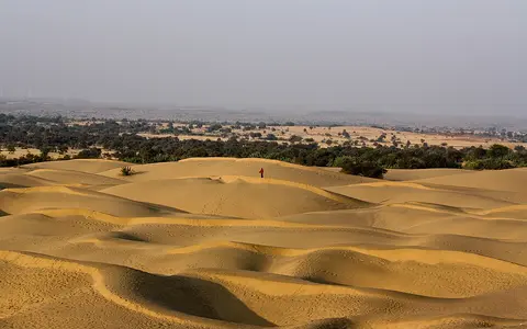

A physical region, not one fixed polygon
“Thar Desert” and “Great Indian Desert” refer to the same broad physical region, although published limits depend on whether the mapper follows active and stabilized dunes, climatic aridity, soils, vegetation, or administrative data. This record uses the transboundary geomorphic desert between the Aravalli and Indus as its subject. It does not use “western Rajasthan,” the “Indian arid zone,” the Rann of Kachchh, or Pakistan's adjoining Cholistan as automatic synonyms.
The approximate 290,000-km² figure above comes from a landform classification that includes 17 provinces on both sides of the international border, among them the Luni alluvial plain, Jaisalmer hamada, Nagarparkar and Rohri uplands, and western dune fields.[1] A separate NRSC/ISRO analysis used a 208,301-km² western-Rajasthan frame from 24°37′ to 30°10′48″N and 69°29′ to 76°05′33″E.[2] That smaller number measures its 12-district study area, not the full transboundary desert. The former “about 200,000 km²” value is therefore not retained as an unqualified total.
Aravalli piedmont to Indus plain
The eastern margin is a transition across the Aravalli hills and piedmonts—the gently sloping aprons built at their feet—toward more dissected and generally wetter Rajasthan. In the west, dune fields and saline alluvial plains merge with the lower Indus plain in Sindh. The northern side meets the Sutlej–Ghaggar alluvial country; the southern landforms descend through the Luni plain toward the low, evaporative Rann of Kachchh.
This is predominantly low-relief terrain, but not a level basin. Rock hills, hamadas (stony bedrock uplands), pediments and dune ridges stand above alluvial and interdunal plains. Relief and surface material therefore change over short distances: the Jaisalmer sector exposes rock and gravel among sand streaks, the central and western sectors carry large dune systems, and the southeast is organized around the southwest-flowing Luni and its tributaries.[1]
Aravalli transition
Hills, rock pediments, piedmont sediment and semi-arid plains interrupt the desert's sandy edge.
Dunes and hamada
Parabolic, transverse, linear and network dunes alternate with sand sheets, gravel pavements and bedrock uplands.
Luni–Rann descent
Alluvial plains, distributary channels and saline lowlands lead toward the Great Rann of Kachchh.
More than a dune field
Kar's regional map divides the desert into 17 geomorphic provinces and estimates that dune fields occupy about 61% of its 290,000-km² frame. Major sandy plains account for another 25%, and major rock or gravel surfaces 14%.[1] Those are mapped landscape classes, not percentages of bare moving sand: many old dunes are partly stabilized, while aeolian sand also veneers alluvial or rocky ground.
Parabolic dune fields occupy the largest mapped tracts, especially in the northeast and south. Transverse ridges occur in the northwest; linear ridges and linked megabarchanoids characterize parts of the far west; isolated star dunes occur in the north. A barchan is a crescent-shaped mobile dune formed under a mainly one-directional wind and limited sand supply; a megabarchanoid is a much larger linked or wavy crescentic ridge. Intervening terrain includes older and younger alluvial plains, colluvial aprons, desert pavements, saline flats, dry beds and rock outcrops.[1]
Season matters. Stronger pre-monsoon winds reactivate sand from roughly March onward; mobility falls when monsoon rain reaches the region in June or early July and raises surface moisture and plant cover. This annual pulse does not move every dune equally. Dune form, size, vegetation, disturbance, available sand and local wind exposure all affect mobility, so a rate from one barchan cannot be generalized to the whole desert.[1]
Himalayan sand recycled by wind and river
The modern sand mantle sits on a much older, composite landscape. Rock weathering and slope wash supply local debris, but river deposits record former drainage from the Aravalli and Himalaya. During drier intervals, wind deflated and reworked exposed alluvium into sheets and dunes; during wetter intervals, rivers, sheetwash and lakes cut or buried aeolian surfaces. The result is an interleaving of fluvial, lake, soil, calcrete and wind-blown deposits rather than one episode of desert formation.[1][7]
A 2024 provenance study compared U–Pb ages of detrital zircon grains with Sr–Nd–Hf isotope signatures. It attributes roughly 30–40% of dune sand across its Thar samples to the Indus system: Sutlej–Beas sources dominate many northern and western samples, while Jhelum, Ravi and Chenab source regions are stronger in central samples. The authors infer that an early- to mid-Holocene Indus–Sutlej floodplain supplied sediment later recycled by seasonal winds.[6] This is a mineralogical source model for sampled sands, not proof that one river formerly crossed every part of the desert.
The exchange now runs both ways. The same zircon study found that southern Thar dune sand forms more than 80% of the present sediment load sampled in the Luni.[6] Wind can therefore deliver inherited river sand to dunes, and a later flood can return that sand to a channel.
One integrated basin and many terminal lows
The Luni is the principal organized drainage of the Indian Thar. The Central Water Commission's Luni subzone report gives the river a length of 482 km and its basin an area of 36,527 km². It rises in the Aravalli hills, crosses western Rajasthan toward the southwest, and loses its channel in the Great Rann of Kachchh rather than maintaining a perennial outlet to the Arabian Sea. The same report lists tributary catchments including the Jawai, Bandi, Sukri, Khari and Jojri systems.[4]
“Ephemeral” means that surface flow is event-driven rather than year-round. Most Thar channels are dry between storms, yet cloudbursts can produce short, high-energy floods that widen channels, scour older beds and spread fresh sand and silt across floodplains. A field study of a 700-m-wide, 5-m-deep Luni section found deposits made mainly by fast, shallow, supercritical floods; reported seasonal peaks may reach 14,000 m³/s, but that is a flood-regime estimate at the investigated reach, not a normal discharge for the river.[5]
Elsewhere, runoff ends in interdunal depressions and playas—shallow closed basins where water ponds and then infiltrates or evaporates, concentrating salts. These internal sinks explain why saline flats and dry lake beds are integral Thar landforms even though surface water is scarce.
What the Ghaggar–Hakra record shows
The Ghaggar–Hakra is a palaeochannel—a former river course—along the desert's northeastern alluvial margin. Satellite and 30-m SRTM topography trace a roughly 5–6-km-wide sinuous low for about 400 km from the Sutlej fan toward the Thar. Sediment cores and mineral ages identify the buried high-energy channel sands as deposits of a former Sutlej course.[8]
Optically stimulated luminescence dates, which estimate when mineral grains were last exposed to light, place initial Sutlej abandonment after about 15,000 years ago and complete avulsion to its present course shortly after about 8,000 years ago. “Avulsion” is an abrupt shift of a river to a different floodplain route. Later fine sediment records weaker, monsoon-fed ephemeral flow in the abandoned valley.[8] This evidence supports a changing drainage network; it does not justify treating every dry line on a map as one continuous former perennial river.
A steep rainfall and water-balance gradient
Rain arrives chiefly with the southwest summer monsoon, but its amount varies strongly across the desert. In the NRSC/ISRO western-Rajasthan study frame, mean annual rainfall ranged from below 100 mm in northwestern Jaisalmer to more than 400 mm near the eastern districts and Aravalli fringe; reported year-to-year coefficients of variation were 40–60%. The same study estimated annual potential evapotranspiration—the atmospheric demand for water from soil and plants—at 2,063.2 mm at Jaisalmer, far above rainfall.[2] The desert boundary therefore grades across a moisture deficit rather than ending at one rainfall contour.
At Jaisalmer station 42328, the India Meteorological Department's 1991–2020 normal is 236.9 mm of rain on 13.1 rainy days a year. June through September contribute 198.9 mm, about 84% of the annual total. May has a mean daily maximum of 42.1°C; the annual mean daily maximum is 34.4°C.[3] These are station normals at one western-Rajasthan point, not desert-wide averages.
Aridity is therefore produced by the combination of low and unreliable monsoon rainfall, a long hot season, very large evaporative demand, and winds that are strongest before the rains. The Aravalli marks an important regional transition, but the Thar should not be reduced to a simple high-relief rain shadow: measured moisture deficiency and monsoon seasonality operate across a broad, low-relief desert–semi-desert gradient.
No single age for the desert
A date for one dune layer is not the “age of the Thar.” Luminescence ages date burial of sand; soil and calcrete horizons date or bracket intervals of surface stability; lake deposits record changing water balance; palaeochannels record former flow routes. Reviews of these archives identify repeated aeolian aggradation and intervening wetter or more stable phases through the late Quaternary, with aeolian activity documented back at least about 250,000 years.[7]
The modern dune field is consequently a reworked surface, not a fossil frozen at one date. Strong wind, rainfall, runoff and vegetation can alter it on seasonal scales, while river avulsion and climatic shifts reorganize sediment over millennia. Broader claims that the desert itself is a certain number of millions of years old confuse the age of underlying rock, an old dry interval, and the age of today's landforms, so no single “formation date” is used here.
From mountain sediment to terminal salt flats
The Thar belongs in the Desert Hub as a monsoon-margin dryland whose surface links uplands, rivers, wind and closed basins. The Himalayas and Aravalli supply different sediment and drainage contexts; the Indus River record follows the western river system whose old floodplain material is recycled through much of the desert.
Read west to east, the region grades from lower-Indus alluvium and Pakistan's Tharparkar dune country through Jaisalmer's mixed sand-and-rock terrain to the Aravalli piedmont. Read north to south, the abandoned Sutlej–Ghaggar corridor gives way to the central dune fields and then to the Luni plain and Rann of Kachchh. Both transects matter more than any single administrative outline.
Sources and measurement notes
- Kar, A., “Quantification of Aeolian Bedform and Process Parameters in Thar Desert for Earth Surface Dynamics”, Annals of Arid Zone 52(3–4), 183–207 (2013; online publication record 2016), DOI 10.56093/aaz.v52i3-4.63198; direct PDF. Source for the approximately 290,000-km² geomorphic frame, 17 provinces, surface-class percentages, dune forms, seasonal mobility, regional margins and composite fluvial–aeolian landscape.
- Pathak, S., “Study of Land Use/Land Covers Dynamics in Thar Desert Using Geospatial Technique”, Annals of Arid Zone 54(1–2), 17–25 (2015). NRSC/ISRO western-Rajasthan study using multi-season AWiFS data at 1:250,000. Source for its 208,301-km², 12-district study frame and coordinates, rainfall gradient and variability, and reported potential evapotranspiration. These dimensions are not treated as a boundary for the whole transboundary Thar.
- India Meteorological Department, Meteorological Centre Jaipur, “Climatological Information: Jaisalmer (42328), Period 1991–2020” (one-page station table, accessed 29 August 2026). Source for monthly and annual mean rainfall, rainy days, and daily minimum and maximum temperatures. The June–September share is calculated here from IMD monthly normals.
- Central Water Commission, Government of India, Lower Indus Basin: Luni Subzone 1(a), general-description and river-system sections (accessed 29 August 2026). Source for the 482-km Luni length, 36,527-km² basin, tributary catchments, and termination in the Great Rann of Kachchh. The figures belong to the report's subzone delineation.
- Carling, P. A. & Leclair, S. F., “Alluvial stratification styles in a large, flash-flood influenced dryland river: The Luni River, Thar Desert, north-west India”, Sedimentology 66, 102–128 (2019). Source for the 700-m-wide, 5-m-deep logged section, usually dry bed, reported flood peaks up to 14,000 m³/s, scour, and supercritical-flow deposits. Those observations are reach-specific.
- George, B. G., Maitra, A. & Anczkiewicz, R., “Monsoon control on evolution of the western Indian aeolian landscape: Insights from U–Pb detrital zircon geochronology and Sr–Nd–Hf isotope studies of the Thar Desert sand dunes”, Geomorphology 466, 109429 (2024). Source for sampled-sand provenance, the 30–40% Indus contribution, regional Himalayan source differences, early- to mid-Holocene floodplain interpretation, and the greater-than-80% dune-sand contribution to sampled Luni sediment.
- Dhir, R. P., “Paleoclimate History and Antiquity of Thar”, Annals of Arid Zone 52(3–4) (2013; online publication record 2016), DOI 10.56093/aaz.v52i3-4.63308. Source for the distinction among aeolian, fluvial, lake, sheetwash, soil and calcrete archives and for aeolian aggradation documented back to about 250 ka.
- Singh, A. et al., “Counter-intuitive influence of Himalayan river morphodynamics on Indus Civilisation urban settlements”, Nature Communications 8, 1617 (2017), DOI 10.1038/s41467-017-01643-9. Source for Landsat and 30-m SRTM mapping of the roughly 5–6-km-wide, 400-km palaeochannel trace, Sutlej sediment provenance, OSL method and dates, avulsion timing, and later monsoon-fed fine sediment.