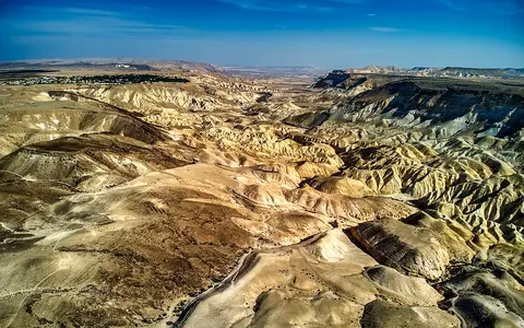

A physical region, not the Southern District
Negev is the accepted English catalog form; the Library of Congress records Negeb as a variant spelling.[1] This page uses Negev Desert for the modern physical dryland south of the Beersheba–Arad transition, not for the smaller “biblical Negev,” the administrative Southern District, the Negev Highlands alone, or the Negev and Arava groundwater basin.
There is no single surveyed desert boundary. A Geological Survey of Israel soil study uses an approximately 10,000 km² frame between about 29° and 31°N, whereas an Israeli Ministry of Education regional description gives about 13,000 km² and explicitly includes Beersheba Subdistrict and part of Ashkelon Subdistrict.[2][3] The figures describe different polygons, so they are not averaged here. For the same reason, no latitude–longitude pair is presented as a definitive desert centre.
Loess plain to highlands, rift margin, and gulf
The broad north lies around Beersheba and the Beersheba–Arad valley, where desert conditions grade into Mediterranean-climate steppe. Westward, related terrain continues across the political boundary into Sinai; dune fields are concentrated near this northwestern margin. South and southeast of the loess-covered northern plain, the ground rises into the Negev Highlands, a dissected tract of plateaus and northeast–southwest folds at roughly 400–1,000 m above sea level.[2][10]
The highlands descend eastward to the Arava, which separates the Negev uplands from the mountains of southern Jordan. The Arava/Araba Fault is the main branch of the Dead Sea Transform between the Dead Sea and Red Sea; geophysical synthesis places it within a broader deformation belt rather than treating the whole valley edge as one simple fault line.[7] Farther south, the Eilat Mountains expose Precambrian crystalline basement and Cambrian sedimentary rocks above the northern Gulf of Aqaba.[4]
Loess and dunes
Windblown silt mantles much of the wetter northern desert; sand is concentrated toward the Sinai margin rather than spread across the whole Negev.
Folded highlands
Carbonate ridges, plateaus, cuestas, scarps, broad valleys, and makhteshim dominate the central cross-section.
Arava and Eilat relief
Fault-zone basins and alluvial fans border rugged crystalline and sedimentary mountain terrain.
Marine strata above older basement
Most exposed rocks across the main Negev plateaus are Cretaceous to younger limestone, dolomite, chalk, marl, and chert deposited when this continental margin was repeatedly covered by shallow seas. Older Triassic to Early Cretaceous sandstone, carbonate, and gypsum appear where deep valleys and makhteshim cut through the cover. In the far south, erosion and faulting expose the much older crystalline basement of the Eilat Mountains.[4]
The central highlands are crossed by northeast–southwest anticlines and synclines—up-arched and down-folded rock layers—of the Syrian Arc fold belt. Different resistance to erosion turns tilted limestone and dolomite beds into ridges and cliffs while softer sandstone, chalk, and marl are stripped into slopes, valleys, and badlands.[5][10]
Breached folds, not impact craters
A makhtesh (plural makhteshim) is a steep-sided erosional basin cut into the crest of an anticline and drained through a narrow outlet. Resistant limestone and dolomite form much of the rim; once drainage breaches that rim, streams remove softer interior strata and enlarge the basin headward. The resulting enclosed-looking form can resemble a crater, but it is neither a meteorite impact structure nor a volcanic caldera.[5]
IUCN’s 2001 technical evaluation reports Makhtesh Ramon at about 42 by 12 km and 450 m deep, Makhtesh Gadol at about 10 by 5 km, and Makhtesh Katan at about 8 by 5 km; it places the walls of the smaller two roughly 300–400 m above their floors.[5] These are dimensions of individual landforms in the central Negev, not dimensions of the desert. The same evaluation links their incision to Pliocene uplift and eastward tilting, while later Geological Survey work dates a broader reorganization of present southern-Negev divides to about 1.8 ± 0.2 million years ago. These dates describe stages in drainage development, not a single “age of the Negev.”[6]
Loess, desert pavement, and active channels
Loess is windblown, silt-rich sediment. A remote-sensing and field study mapped Negev loess over approximately 5,500 km² and found that it is dominated by coarse silt grains 20–60 micrometres across, with a finer 3–8 micrometre mode. In the northern Negev it can mantle whole slopes and plains; farther south it is increasingly confined to valleys and depressions.[8] The 5,500 km² value is the study’s loess extent, not the area of the desert.
The same study distinguishes primary loess accumulated directly from dust from secondary loess reworked by runoff. Its dated hilltop sequence began accumulating around 95,000 years ago and also preserves an older interval around 180,000–130,000 years ago.[8] Elsewhere, stable gravel surfaces develop desert pavement, while rare floods cut valley fill and move fine sediment downstream. The Negev surface is therefore a patchwork of old, slowly weathering interfluves and much younger active channels.
Named basins lead to different terminal waters
The Negev is not one endorheic basin. In the north and northwest, the Hebron–Beersheba–Besor system drains toward the Mediterranean through the Gaza Strip. A basin-scale study gives that transboundary catchment as about 3,500 km² and notes that its natural channels are mainly ephemeral, apart from small springs.[9] The drainage basin extends beyond the physical Negev and should not be used as a desert boundary.
Across the central divide, Nahal Zin drains northeast to the Dead Sea. A 2021 hydrometeorological study defines the Zin basin as about 1,400 km², falling from roughly 1,000 m above sea level in its western headwaters to about 380 m below sea level at the eastern end.[12] Farther south, Nahal Paran and adjacent basins drain toward the Arava; Geological Survey field mapping gives the modern Paran catchment as about 3,800 km² and shows how stream capture and eastward tilting reorganized former west-flowing channels during the early Pleistocene.[6]
These channels are wadis—normally dry or discontinuously wet stream beds—not permanent rivers. In the Zin basin, sandy and alluvial reaches lose floodwater through the channel bed. Bare rock and thin soils can instead produce rapid hillslope runoff: during the studied April 2018 storm, flow began within minutes of intense local rain and peak discharge followed within tens of minutes.[12] A flood can therefore be large at one gorge while a neighboring catchment receives little rain.
Mediterranean winters, Red Sea troughs, and relief
The north–south rainfall decline is measurable but should not be reduced to one timeless desert average. A Geological Survey report using Israel Meteorological Service records gives mean annual rainfall of 191.6 mm at Beersheba for 1957–2009 and 89.7 mm at Sede Boqer for 1952–2018.[11] Because the records cover different periods and places, the values are station examples, not a single climate normal or a calculated rate of decline.
At Sede Boqer, published 1991–2020 monthly data place rain mainly between October and May. Atlantic–Mediterranean cyclones supply most rain to the northern and central Negev, whereas the Red Sea Trough contributes a substantial share of southern-Negev rainfall.[10] Elevation locally cools and moistens the highlands, but the broader gradient continues into a hyperarid south where long dry intervals are interrupted by spatially small, intense storms.
The Zin basin illustrates how climate controls process. For 1980–2009, its study reports mean annual rainfall declining from about 90 mm in the higher west to 60 mm in the lower east, and an average of only 16 rainy days (at least 1 mm) per year in the west and eight in the east.[12] Sparse vegetation, exposed bedrock, storm intensity, and the location of a convective cell then determine whether rain infiltrates locally, runs onto a fan, or becomes a channel-changing flash flood.
A desert between Sinai and the Dead Sea Transform
Read westward, the Negev’s dunes, loess, carbonate plateaus, and wadis continue into Sinai across a political border that does not end the landforms. Read eastward, its drainage and relief are tied to the Arava segment of the Dead Sea Transform and to the Dead Sea basin. The wider Arabian Desert lies beyond the Jordanian uplands; the Syrian Desert offers a useful comparison farther northeast. Return to the Desert Hub for other dryland regions.
Sources and measurement notes
- Library of Congress, Library of Congress Subject Headings, section N, 42nd edition (2020), p. 94. The authorized heading is “Negev (Israel)”; “Negeb (Israel)” is a variant.
- Crouvi, O., Amit, R., Enzel, Y. & McDonald, E., Geological Survey of Israel, Spatial Patterns of Topsoil Grain Size in the Negev Desert, Israel (research poster; accessed 29 August 2026). Source for the approximately 10,000 km² physical-study frame, 29–31°N span, semi-arid to hyperarid gradient, and broad dune and loess distribution.
- Israel Ministry of Education, “The Negev” (Hebrew; accessed 29 August 2026). Gives an approximately 13,000 km² regional definition that includes Beersheba Subdistrict and part of Ashkelon Subdistrict; retained to explain why it is not interchangeable with the smaller physical-desert study frame.
- Vaks, A., Geological Survey of Israel, Quaternary Paleoclimate of the North-eastern Boundary of the Saharan Desert: Reconstruction from Speleothems of Negev Desert, Israel, Report GSI/14/08 (2008), section 2.3. Used for the regional stratigraphic framework and the crystalline and Cambrian exposures of the Eilat Mountains.
- IUCN, World Heritage Nomination—The Makhteshim Country (Israel): Technical Evaluation (2001), pp. 39–40. Source for fold-belt setting, erosional mechanism, rim lithology, drainage outlets, and the reported dimensions of Ramon, Gadol, and Katan; these are landform measurements, not desert dimensions.
- Guralnik, B., Matmon, A., Avni, Y., Zilberman, E. & Ginat, H., “Quaternary Tectonics and Drainage Evolution in the Southern Negev”, Geological Society of Israel annual-meeting field guide (2013), pp. 56–71. Source for Paran catchment area, early-Pleistocene drainage reorganization, exposure-dated wind gaps, eastward tilting, stream capture, and the 1.8 ± 0.2 Ma divide age.
- Weber, M. et al., U.S. Geological Survey publication record, “Anatomy of the Dead Sea Transform from Lithospheric to Microscopic Scale”, Reviews of Geophysics 47 (2009), doi:10.1029/2008RG000264. Source for the Arava/Araba Fault’s position, plate-boundary context, and distributed fault-zone structure.
- Crouvi, O., Amit, R., Porat, N., Gillespie, A. R., McDonald, E. V. & Enzel, Y., “Significance of Primary Hilltop Loess in Reconstructing Dust Chronology, Accretion Rates, and Sources: An Example from the Negev Desert, Israel”, Journal of Geophysical Research: Earth Surface 114 (2009). Source for mapped loess extent, grain-size modes, geographic distribution, and dated primary-loess intervals.
- Tal, A. et al., “Chemical and Biological Monitoring in Ephemeral and Intermittent Streams: A Study of Two Transboundary Palestinian–Israeli Watersheds”, International Journal of River Basin Management 8(2), 185–205 (2010). Source for the approximately 3,500 km² Hebron–Besor basin, its route to the Mediterranean, and its naturally ephemeral hydrology.
- Langgut, D. & Finkelstein, I., “Environment, Subsistence Strategies and Settlement Seasonality in the Negev Highlands (Israel) during the Bronze and Iron Ages: The Palynological Evidence”, PLOS ONE 18(5), e0285358 (2023), section 2.1. Used only for modern highland elevation, 1991–2020 Sede Boqer seasonality, and Mediterranean-cyclone/Red Sea Trough controls.
- Horowitz, T., Geological Survey of Israel, Control of Climate Properties on Long Term Soil Water Distributions in Semi-arid and Arid Soils with Implications on Pedogenic Salts, Report GSI/13/2020 (2020), table 1. The source identifies separate station records; this page retains their distinct observation periods rather than treating them as one normal.
- Rinat, Y. et al., “Hydrometeorological Analysis and Forecasting of a 3 d Flash-flood-triggering Desert Rainstorm”, Natural Hazards and Earth System Sciences 21, 917–939 (2021). Source for Zin basin area, elevation range, 1980–2009 rainfall and rainy-day gradients, transmission losses, and the measured timing of the April 2018 runoff response.