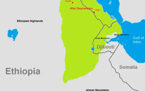

Desert, depression, and Afar are not identical
Danakil Desert is a landscape and climate name. Danakil Depression is the narrower, fault-bounded northern rift trough that straddles Ethiopia and Eritrea; Afar Depression or Afar Triangle usually denotes the larger lowland and plate-junction region extending farther south and east. “Afar Desert” is sometimes used broadly, but it does not establish a single mapped boundary.[1][5]
This record uses the mapped Danakil Depression as its physical frame because it supplies reproducible limits and measurements. It covers the desert landforms from the Gulf of Zula sector in Eritrea south through Dallol and the Erta Ale–Tat Ali axis to the Harak/Afdera sector in Ethiopia. The wider dry Afar lowlands, including those in Djibouti, belong to the regional setting but are not silently counted in the dimensions above.[1][5]
Even depression dimensions depend on the mapped edge. The 2023 rift-wide structural study measures about 200 km by 50–150 km, whereas a 2019 Dallol-focused review describes a roughly 250-km lowland, locally widening from about 15 to 70 km. The studies trace different physiographic or structural limits; this page reports the newer 200-km Gulf of Zula–Harak frame instead of averaging incompatible extents.[1][5]
Plateau, rift floor, and Danakil Block
On the west, border faults drop from the Ethiopian–Eritrean Plateau to a chain of marginal grabens and coalescing alluvial fans. The western fault system has roughly 3 km of topographic relief. Across the low centre, the Dallol salt basin and the north-northwest-trending Erta Ale and Tat Ali magmatic segments occupy different parts of the rift axis. On the east, the Danakil Block—also called the Danakil Alps or Mountains—generally stands about 0.5–1 km above sea level and separates much of the trough from the Red Sea.[1]
This arrangement explains the desert's sharp contrasts. Sediment fans spread away from the high western escarpment; nearly level evaporite floors occupy closed lows; and volcanic shields, fissure-fed lava fields, and fault scarps rise through or overlie the basin fill. In Eritrea, Alid lies on the northern spreading axis about 30 km south of the Gulf of Zula, confirming that the tectonic and volcanic system continues beyond the better-known Ethiopian salt plain.[7]
Border faults and fans
Highland runoff crosses steep scarps, enters wadis, and spreads gravel, sand, and mud across basin-margin fans.
Salt and brine floor
Halite pans, gypsum pavement, mud layers, and shallow brine record repeated flooding, concentration, and desiccation.
Basaltic volcanic ridges
Aligned shields, cones, fissures, and lava fields mark zones where magma accommodates part of the plate extension.
Faulting and magma divide the extension
The Danakil occupies the on-land continuation of the Red Sea rift near the junction of the Arabian, Nubian, and Somalian plates. Geophysical compilations place crustal thickness below 15 km in the northern depression, compared with about 40–45 km beneath the Ethiopian Plateau. GPS-derived opening rates cited by a 2023 synthesis rise southward from about 7 mm per year near 15°N to about 20 mm per year near 13°N.[1] These are regional plate-extension rates, not the slip rate of any one visible fault.
Extension does not produce one simple graben. Along the rift axis, magma intrudes dykes and feeds volcanic segments; between and beyond those segments, normal faults divide the floor into tilted and down-dropped compartments. Mapping of more than 500 axial structures found faulting more important where surface magmatism is weaker, while magma dominates extension within the principal volcanic segments. The depression is thus transitional between a continental rift and a spreading ridge, but it is not yet described as a continuous strip of oceanic crust.[1]
A former marine basin now below sea level
Reef remnants and marine sediment show that Red Sea water formerly occupied the northern basin. Dating summarized in recent structural work places the last normal-marine water at about 120,000 years ago, during Marine Isotope Stage 5e. Tectonic and volcanic barriers near the Gulf of Zula then isolated the lowland; continued subsidence created space in which marine- and groundwater-fed brines deposited gypsum, halite, and potash-bearing layers.[1][2]
The modern Dallol salt pan covers about 400 km² and lies asymmetrically near the west side of the depression—about 5 km from the highland escarpment but roughly 50 km from the eastern margin in the cited mapping. Seismic profiles and approximately 120 borehole logs reveal a fault-bounded, 6–10-km-wide sub-basin containing more than 1 km of evaporites interpreted as roughly 100,000 years old.[2] Those subsurface thicknesses apply around Dallol, not to every salt surface in the Danakil Desert.
Dallol itself requires careful terminology. The Smithsonian catalog locates the named volcanic feature at 14.242°N, 40.300°E and lists its elevation as −48 m, whereas the surrounding pan lies near −116 to −120 m. These figures describe different surfaces and should not be merged; the sources do not state a shared vertical datum. Field mapping describes the dome as about 40 m high and proposes that a basaltic intrusion younger than 6,000 years uplifted lacustrine salt beds, with magma–salt interaction, dissolution, collapse, and hydrothermal mineral precipitation continuing to reshape the complex.[4][6]
Water enters closed lows and leaves mainly as vapour
The depression is endorheic: surface flow ends inside the basin rather than reaching the sea. Rain falling on the escarpments can run through wadis as short-lived floods, carry clay and gravel onto fans and pans, infiltrate coarse sediment, or become groundwater moving toward the low floor. At Dallol, sheetflood clay settles on the pan before evaporation raises brine salinity enough for new halite crusts to form.[2][4]
Lake Afdera—also published as Afrera, Giulietti, or Egogi Bad—is a separate hypersaline terminal lake in the southern part of the depression. A complete bathymetric survey made with an echosounder during 2016 and 2017 measured a mean depth of 20.9 m, maximum depth of 80 m, and volume of 2.4 km³. The same study derived a 117-km² surface and −112-m water level from 1-arc-second Shuttle Radar Topography Mission data; historical comparisons indicated no large lake-level change over the preceding 50 years.[3] The measurements describe Lake Afdera, not Lake Karum/Assale or the Dallol pan.
Hot-desert climate with sparse, erratic rain
The low Danakil is classified BWh in the Köppen–Geiger system: a hot desert climate. A 2019 field synthesis for the Dallol region reports average annual rainfall ranging from less than 50 to 200 mm across available descriptions and emphasizes strong year-to-year variability. It also reports winter daily means above 30°C on the salt plain and routine daytime temperatures above 40°C.[5] These are Dallol-area observations and compiled values, not a current climate normal for the entire Danakil Desert.
Persistent heat reflects low latitude, clear and dry conditions, and ground near or below sea level; surrounding high terrain and the scarcity of dependable rain-bearing weather leave evaporation far greater than direct precipitation on the floor. Geothermal heat is locally decisive at springs and altered ground but should not be confused with the atmospheric controls on the regional desert climate. Rare storms still matter: floodwater can move sediment across fans, dissolve older salt, inundate parts of the nearly level pan, and then leave new mud and evaporite layers as it disappears.[2][4]
Eruptions, intrusions, faults, and floods
Volcanism is not merely inherited scenery. The Smithsonian Global Volcanism Program profile for Erta Ale describes a roughly 50-km-wide basaltic shield with a 0.7 × 1.6 km summit crater and records 2025 as its latest known eruption as of this page's 29 August 2026 review.[6] The date is catalog status, not a promise that activity has ceased. At Dallol, satellite and field evidence links a 2004 dyke intrusion to renewed fracturing and northward migration of hydrothermal activity.[4]
Fault displacement lowers some compartments while lava constructs ridges and can block or redirect drainage. Hydrothermal fluids dissolve and reprecipitate salt; seasonal or exceptional floodwater shifts shallow brines and pan margins. These processes operate at different rates and scales, which is why one elevation, lake outline, or hydrothermal map cannot stand indefinitely for the entire desert.
A salt desert on a separating plate boundary
The Danakil belongs in the Desert Hub as a rift-floor desert rather than a generic sand desert. Its most useful regional transect runs from the high western escarpment across alluvial fans and the Dallol salt sump, over the Erta Ale volcanic axis, and toward the Danakil Block and Red Sea margin.
For another internally drained salt landscape, compare the Dasht-e Kavir; its Iranian Plateau setting and mud–salt processes differ from Danakil's active spreading axis. The Namib Desert offers a contrasting African coastal desert organized chiefly by ocean–atmosphere circulation rather than by a below-sea-level rift basin.
Sources and measurement notes
- Hurman, G. L. et al., “Quantitative Analysis of Faulting in the Danakil Depression Rift of Afar: The Importance of Faulting in the Final Stages of Magma-Rich Rifting”, Tectonics (2023). Source for the mapped 200-km by 50–150-km depression, margin relief, plate and crustal setting, GPS-derived opening rates, fault mapping, volcanic-segment geology, below-sea-level range, and approximately 120-ka last marine incursion.
- Bastow, I. D. et al., “The Development of Late-Stage Continental Breakup: Seismic Reflection and Borehole Evidence from the Danakil Depression, Ethiopia”, Tectonics (2018). Uses four seismic-reflection profiles and about 120 borehole records around Dallol; source for salt-pan area and position, pan elevation, marine-to-pan history, sheetflood deposition, sub-basin width, and local evaporite thickness. Elevations are reported relative to sea level without a named vertical datum.
- Schaegis, J.-C. et al., “Novel Bathymetry of Lake Afdera Reveals Fault Structures and Volcano-Tectonic Features of an Incipient Transform Zone (Afar, Ethiopia)”, Frontiers in Earth Science 9, 706643 (2021). Surface area and water elevation come from 1-arc-second SRTM terrain data; depths and volume come from echosounder surveys in January–February 2016 and 2017.
- López-García, J. M. et al., “Origin and Evolution of the Halo-Volcanic Complex of Dallol: Proto-Volcanism in Northern Afar (Ethiopia)”, Frontiers in Earth Science 7, 351 (published 2020). Field, stratigraphic, geochemical, satellite, drone, and thermal-image evidence for salt-plain flooding, the Dallol dome dimensions and proposed age, and the intrusion–salt–hydrothermal model.
- Cavalazzi, B. et al., “The Dallol Geothermal Area, Northern Afar (Ethiopia)—An Exceptional Planetary Field Analog on Earth”, Astrobiology 19(4), 553–578 (2019). Used for the Ethiopia–Eritrea and wider Afar setting, the alternative depression dimensions, Dallol-area Köppen class, compiled rainfall range, and local temperature observations. The reported climate values are not presented here as a modern desert-wide climatological normal.
- Smithsonian Institution, Global Volcanism Program, “Erta Ale” and “Dallol”, volcano profiles (accessed 29 August 2026). Source for catalog coordinates, elevations, morphology, and latest-known-eruption fields. Dallol's catalog elevation describes the named feature above the lower surrounding salt pan.
- Duffield, W. A. et al., U.S. Geological Survey and Eritrean Ministry of Energy, Mines and Water Resources, Geothermal Potential of the Alid Volcanic Center, Danakil Depression, Eritrea, Open-File Report 97-291 (1997). Used for the northern Eritrean rift geometry, Alid position, volcanic rocks, and relationship to the Gulf of Zula; older stable physical relationships only.