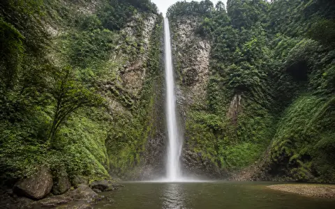
What Wli Falls is
Wli Falls lies near Wli in Ghana's Volta Region, east of Hohoe and close to the international boundary with Togo. It occupies the western side of the Akwapim-Togo highlands, within the Agumatsa Wildlife Sanctuary and the larger Dayi River basin.
The waterfall is often described in terms of upper and lower sections. For physical geography, the essential form is a highland channel reaching an abrupt break in slope: the river approaches through steep, forested terrain, crosses a resistant rock edge, falls into a pool at the foot of the cliff, and continues across lower ground. About 80 metres is the height most commonly reported for the principal drop, although published figures vary.
Range front, cliff, and plunge zone
The Akwapim-Togo ranges trend southwest to northeast along eastern Ghana and continue across the national boundary. Around Wli, this highland belt rises sharply above the lower basin surface to the west. The contrast in elevation gives the Agumatsa River enough gradient to form a sustained free fall rather than a short rapid or low cascade.
At the brink, the channel narrows and crosses the cliff edge. Falling water accelerates, breaks into spray, and transfers energy to the pool and rock debris below. Turbulence, weathering, and block fall gradually enlarge the plunge zone, while the downstream channel removes loosened material. These linked processes maintain the sharp local relief even as the waterfall face changes over long periods.
Border-highland catchment
Runoff gathers on steep uplands near the Ghana-Togo boundary.
Resistant cliff band
The river crosses an abrupt range-front ledge and forms the principal drop.
Pool and lower valley
Water regathers at the cliff foot before entering gentler Dayi basin terrain.
Folded and fractured highland rock
The regional highlands belong to the Togo structural series, a varied assemblage that includes quartzite, sandstone, shale, phyllite, schist, and locally silicified limestone. These rocks were deformed into a narrow mountain belt, leaving folded layers, fractures, and bands with different resistance to weathering.
That contrast helps explain the steep escarpment setting. Harder rock units can preserve a pronounced ledge while weaker or more fractured material is removed more readily from the slope and channel. The exact cliff profile reflects local structure as well as river erosion: joints provide release surfaces for rockfall, and the orientation of rock layers influences how the face retreats.
Perennial flow with strong seasonal variation
The Agumatsa is a tributary of the Dayi and carries water from the border highlands toward the lower basin. Wli Falls flows throughout the year, but perennial does not mean constant. Rainfall over the small upland catchment, soil storage, shallow groundwater, and evaporation all influence discharge at the brink.
During wetter periods, runoff spreads the falling water across more of the rock face, strengthens the main curtain, and increases turbulence in the plunge pool. Drier conditions narrow the flow and expose more cliff. Because the catchment is compact and steep, intense rain can also produce relatively quick changes in discharge compared with a waterfall supplied by a large lake or broad lowland river.
Two rainy seasons and highland uplift
The Dayi basin has a tropical climate influenced by moist southwesterly air from the South Atlantic and seasonally dry harmattan air from the Sahara. Rainfall is bimodal: the main wet season generally runs from about mid-April into July, and a second, less continuous wet period occurs from September into November.
Relief increases rainfall on the higher ranges relative to the adjacent plains. Moist air rising over the escarpment cools and can add to rainfall in the Agumatsa headwaters. This topographic effect, combined with the two seasonal rainfall peaks, supports year-round flow while still producing substantial month-to-month and year-to-year variation at the falls.
From the Agumatsa highlands to Lake Volta
Below Wli Falls, the Agumatsa crosses the lower Hohoe landscape and enters the Dayi River network. The Dayi drains south and west through the Volta Region before discharging into Lake Volta. Wli is therefore a local range-front landform nested within the much larger Volta basin.
This sequence links a small mountain catchment to successive scales of drainage: upland channels feed the waterfall, the Agumatsa carries water away from the cliff, the Dayi integrates tributaries across the regional lowlands, and Lake Volta receives the downstream flow. Wli Falls connects most directly to the waterfalls hub, the rivers hub, and the terrain index.