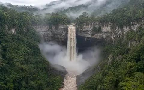
What Tequendama Falls is
Tequendama Falls, or Salto del Tequendama, lies on the Bogotá River in the rural part of Soacha municipality, Cundinamarca. Its position near the southwestern edge of the Bogotá metropolitan region is geographically important: here the river reaches the outlet of the Bogotá Savanna, a high intermontane plain within the Eastern Cordillera of the Colombian Andes.
Across the savanna, the Bogotá follows a low-gradient course over a broad basin floor. At Tequendama, that subdued river profile ends abruptly. The channel enters resistant, folded sedimentary terrain, crosses the main rock lip, and descends into a narrow, deeply enclosed valley. The falls therefore mark more than a local cliff; they form the principal transition from the river's high, relatively level middle basin to its steep lower course.
From high savanna to confined gorge
The Bogotá Savanna is not a flat plateau surface in the simplest sense. It is a structural and sedimentary basin enclosed by ridges of the Eastern Cordillera and partly filled by river, lake, wetland, and slope deposits. The Bogotá River meanders across this comparatively low-relief floor before converging on its southwestern outlet near Soacha.
At the falls, the valley geometry changes rapidly. The channel narrows, the river crosses a pronounced knickpoint, and the receiving valley is bounded by steep rock walls and wooded slopes. Falling water is broken into spray within the enclosed gorge, then gathers in the channel below and continues through terrain that loses elevation much more quickly than the upstream savanna.
Broad high basin
The river collects headwater, tributary, urban, and wetland drainage across the Bogotá Savanna.
Abrupt knickpoint
A resistant bedrock threshold interrupts the river's gentle upland profile with a major vertical drop.
Steep lower valley
The Bogotá enters a confined Andean corridor on its way toward the Magdalena lowlands.
Layered rock at the savanna outlet
The Tequendama area exposes sedimentary formations deposited near the end of the Cretaceous and beginning of the Cenozoic, before uplift created the modern Eastern Cordillera. Regional mapping includes thick quartz-rich sandstones, finer siliceous beds, mudstones, and younger continental strata. Folding and faulting later tilted, fractured, and repeated parts of this sequence as the Andes rose.
Differences in rock strength help maintain the sharp break in slope. Resistant sandstone-rich units form steep ribs and cliff sections, while fractures and less durable beds provide routes for weathering, seepage, and erosion. The river exploits these weaknesses, and rockfall, spray weathering, and channel scour continue to reshape the gorge. Tequendama is thus an active erosional threshold cut into an already deformed mountain structure.
The wider basin history also matters. As uplift and incision reorganized drainage, water and sediment accumulated on the high savanna while the outlet river cut toward the lower Magdalena basin. The present waterfall preserves the contrast between that sediment-filled upland depression and the more deeply incised terrain beyond its rim.
A large upstream basin with managed flow
The Bogotá River rises in the Guacheneque páramo north of the capital and travels through the upper and middle basin before reaching Tequendama. Along the way it receives numerous tributaries from the mountains surrounding the savanna, including streams crossing agricultural land and the metropolitan area. The discharge at the falls therefore integrates rainfall and water use across a densely occupied Andean basin rather than a small local catchment.
Modern flow is strongly modified. Reservoirs, pumping works, hydroelectric facilities, and the Alicachín gates near Soacha route and regulate water around the savanna's outlet. During high-flow periods the gates may release large volumes downstream; at other times diversion through the Bogotá River hydroelectric chain can reduce the water passing visibly over the natural lip. The falls' width and spray cannot be read as a simple measure of rainfall alone.
Water quality is also part of the river's physical condition. Municipal and industrial discharges from the upper basin have historically carried a heavy pollutant load toward Tequendama, while treatment and river-recovery works continue upstream. The plunge creates intense turbulence and aeration, but a waterfall does not remove the full dissolved and suspended load accumulated across the basin.
Tropical highland rainfall shaped by relief
Tequendama lies at tropical latitude but high elevation, so temperature conditions near the brink are much cooler than in the Magdalena lowlands. Moist air, frequent cloud, and the steep western margin of the savanna support mist around the gorge. Spray from the waterfall adds local moisture when discharge is high, but cloud and fog also form independently as air moves across the mountain terrain.
Rainfall across the Bogotá basin commonly follows a two-peak annual pattern as the tropical rain belt shifts over the northern Andes. Wetter periods generally occur in boreal spring and again in autumn, separated by relatively drier intervals around the turn of the year and in midyear. Elevation, slope orientation, and local storms produce substantial variation across the large catchment.
These controls reach the falls through the whole river network. Prolonged rain can raise savanna water levels and require greater releases at Alicachín, increasing discharge through the gorge. Drier conditions reduce natural runoff, but the engineered water system means that the response at the brink also depends on reservoir and power-generation operations.
From Andean headwaters to the Magdalena
Tequendama separates two contrasting reaches of one river. Upstream lies the high Bogotá basin, whose headwaters and tributaries drain the ridges and páramos around the savanna. Downstream, the Bogotá descends through the Tequendama region, receives tributaries such as the Apulo and Calandaima, and reaches the Magdalena River at Girardot.
The basin connection continues north through the Magdalena valley to the Caribbean Sea. Tequendama Falls is therefore a conspicuous step in a much longer source-to-sea system: water crosses from a cool high-Andean basin into progressively warmer and lower terrain before entering Colombia's principal inter-Andean river corridor.
Within Geography Atlas, the falls connect most directly to the Andes record, the waterfalls hub, the rivers hub, and the terrain index. Together they place the cliff within the linked geography of mountain uplift, basin filling, river incision, and downstream drainage.