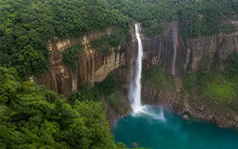
What Nohkalikai Falls is
Nohkalikai Falls lies in East Khasi Hills district near Sohra, the town historically known as Cherrapunji. It stands close to the southern margin of the Khasi uplands, part of the larger Meghalaya or Shillong Plateau, where high ground breaks sharply toward the Sylhet lowlands of Bangladesh.
The landform is commonly described as a roughly 340-metre plunge. Its geographic character comes from the contrast between scales: a comparatively small stream crosses the upland surface, but the edge it reaches is a major regional escarpment. Water passes over a narrow brink, descends beside a near-vertical rock face, enters a plunge pool, and then continues through a confined lower gorge.
Plateau rim, free fall, and gorge
The Sohra Plateau is not a flat table throughout, but it contains broad upland surfaces cut by short streams and bounded by deeply dissected slopes. At Nohkalikai, one of these channels reaches an abrupt break in gradient at the plateau rim. The overhanging or very steep face allows the water to separate from the rock, producing a plunge rather than a long cascade.
At the base, impact, turbulence, and circulating sediment concentrate erosion within the plunge pool. Spray wets the surrounding cliff and broken water regathers in the lower channel. Over long periods, weathering along fractures, removal of loosened blocks, and erosion at the foot of the fall can shift the cliff edge headward while the downstream gorge lengthens into the plateau.
Compact upland catchment
Rainfall gathers in a short channel network on the plateau near Sohra.
Sharp scarp knickpoint
The stream crosses an abrupt break in slope and clears the cliff as a single plunge.
Pool and incised gorge
Falling water transfers energy to the pool before draining through steep lower terrain.
Layered rock on the Meghalaya Plateau margin
The southern Meghalaya Plateau combines ancient crystalline foundations with younger sedimentary rocks. Around Sohra, the sedimentary sequence includes sandstone, shale, and limestone. These materials do not weather at the same rate: resistant beds can retain steep ledges, while weaker layers and fractured zones are removed more readily by water and slope processes.
The cliff form also reflects joints and other breaks in the rock. Water enters these openings, chemical weathering weakens mineral and carbonate material, and repeated saturation can help detach blocks from the face. Nohkalikai is therefore part of a broader dissected scarp landscape rather than an isolated drop created only by the present stream.
Runoff controlled by a small catchment
The feeder stream is supplied mainly by rain falling on the plateau above the falls. It is not buffered by a large lake, glacier, or extensive river basin. As a result, discharge can respond rapidly to storms, soil saturation, and the progression of the monsoon.
During wet months, stronger runoff thickens and broadens the falling column, enlarges the spray zone, and increases turbulence in the pool. Through the drier winter season, flow contracts substantially and more of the rock face becomes exposed. The falls can retain water beyond individual storms because saturated soils, shallow groundwater, and small upland storage release water gradually, but the seasonal contrast remains pronounced.
Monsoon air lifted against the Khasi Hills
Sohra's rainfall is controlled by its position above the lowlands north of the Bay of Bengal. Moist southwesterly monsoon air crosses Bangladesh and meets the steep southern face of the Khasi Hills. Forced upward, the air cools and condenses, producing exceptionally heavy orographic rain over the plateau rim and nearby uplands.
Most runoff is generated during the monsoon months, when repeated storms can keep soils wet and channels active. Cooler, drier continental air becomes more influential in winter, sharply reducing rainfall and stream discharge. Cloud, fog, and wind at the scarp also affect evaporation and the way spray is dispersed along the cliff.
From the Sohra upland to the Bangladesh plains
Nohkalikai belongs to a set of short, steep south-draining streams that cut the southern Khasi escarpment. These channels descend through gorges toward much lower terrain along the India-Bangladesh margin. The regional transition is abrupt: plateau surfaces and deeply incised valleys give way southward to the broad alluvial lowlands of the Sylhet basin.
This setting explains why the Sohra area contains many waterfalls even though their feeder streams may have modest catchments. Strong relief supplies the vertical drop, monsoon rainfall supplies the seasonal water, and resistant rock preserves sharp channel steps. Nohkalikai connects most directly to the waterfalls hub, the rivers hub, and the terrain index.