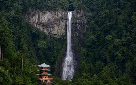
What Nachi Falls is
Nachi Falls, also known as Nachi no Ōtaki, lies near Nachikatsuura on the southeastern side of Japan's Kii Peninsula. The waterfall occupies a confined mountain valley within the Nachi highlands, close to the outer Pacific margin of the Kii Mountains. Its source is a small, wooded upland catchment rather than a large lake or long trunk river.
The main fall is reported at 133 metres high and approximately 13 metres wide. Near the brink, irregularities in the rock divide the stream into several narrow strands before the water recombines visually during its descent. The 133-metre figure refers to this principal free-falling stage; other cascades occur farther upstream in the same rugged headwater landscape.
Cliff edge, free fall, and plunge zone
Above the falls, runoff converges through a steep forested basin and enters a narrow bedrock channel. The waterfall begins at an abrupt knickpoint where the channel floor ends at a near-vertical face. Because the lip projects above the lower cliff, much of the water separates from the rock and descends as a plunge rather than sliding down a long cascade.
At the base, the falling column transfers energy into a confined plunge zone. Water impact, turbulent circulation, and sediment moved during high flows attack joints and weaker material at the foot of the cliff. Weathering and occasional rock detachment also alter the face. These processes maintain a strong break between the upper channel and the lower valley, even as the edge changes over long timescales.
Forested headwaters
Rain is gathered and released through a compact mountain catchment immediately inland from the Pacific coast.
Resistant rock lip
The stream crosses a hard bedrock threshold and leaves the cliff as a narrow vertical fall.
Steep lower valley
Water regathers below the plunge and continues through the short, high-gradient Nachi drainage.
Hard igneous rock beside softer basin deposits
The Nachi mountain block is underlain in part by the Kumano acidic igneous rocks, including resistant granitic porphyry formed when magma intruded the region during the Miocene. Nearby terrain also exposes sedimentary rocks deposited in an ancient forearc basin. The two rock bodies differ in structure and resistance to erosion.
Nachi Falls occupies the steep boundary between these units. The igneous rock has been removed more slowly than the comparatively erodible sedimentary strata, allowing a high cliff to persist. Fractures guide water and weathering across the hard rock, while erosion of weaker material below helps preserve the pronounced step in the stream profile. The waterfall is therefore tied to regional geology, not simply to the volume of its present-day flow.
A compact catchment with a rapid rainfall response
The fall is supplied by precipitation over the forested Nachi headwaters. Local authorities describe a source area of roughly 500 hectares, small enough for discharge to respond quickly to prolonged rain and intense storms. Forest soils, weathered rock, and shallow groundwater store part of that water and release it between rain events, helping sustain flow beyond the immediate storm period.
During wet conditions, the falling column thickens, spray expands across the lower cliff, and the plunge zone receives more sediment and woody material. In drier intervals, the stream contracts and the divisions at the brink become clearer. The waterfall remains part of the Nachi River system: water from the upper mountain channels passes into the lower valley, where a short, boulder-rich river crosses a narrow lowland before reaching Nachi Bay.
Heavy rain on a Pacific-facing mountain flank
The southeastern Kii Peninsula has a humid temperate climate strongly influenced by the Pacific Ocean. Moist air approaching the peninsula is lifted across steep mountain slopes, increasing rainfall over the windward highlands. The wider Kii Mountains include areas receiving more than 3,000 millimetres of precipitation in a year, and the Nachi catchment shares this wet regional setting.
Rain falls in every season, but the largest runoff commonly accompanies the early-summer rainy season, later summer monsoon moisture, and typhoons or other intense rain systems from summer into autumn. Seasonal temperature changes affect evaporation and soil moisture, yet there is no snowmelt-dominated flow regime at the falls. Short, steep channels can rise rapidly when heavy rain saturates the basin.
From the Kii uplands to the Pacific coast
Nachi Falls is one vertical step within a compact mountain-to-coast drainage system. Upstream, ridges and wooded slopes collect rain in the Nachi highlands. Downstream, the channel enters the Nachi River, which carries water and coarse sediment through an increasingly open valley. Near the coast, the river crosses a narrow lowland and enters Nachi Bay on the Kumano Sea.
The short distance between high relief and the sea gives the river a steep overall gradient and leaves limited space for a broad floodplain. Boulder-rich channels, small alluvial fans, and fragmentary river terraces record the transfer of weathered rock from the mountains toward the coast. Nachi Falls connects most directly to the waterfalls hub, the rivers hub, and the terrain index.