Overview
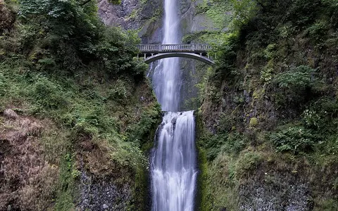
The falls lie on the south wall of the Columbia River Gorge, about 30 miles (48 kilometres) east of Portland. Multnomah Creek drains the northern slope of Larch Mountain before reaching the abrupt gorge margin. The creek first makes a 542-foot (165-metre) upper plunge, crosses a short sloping reach, and then drops another 69 feet (21 metres). Together with the intervening descent, the two tiers form a total fall of 620 feet.
620 ft / 189 m
Two main tiers separated by a short, sloping channel reach.
Multnomah Creek
A short tributary descending directly to the Columbia River.
Hanging valley
A tributary channel meets the much deeper Columbia Gorge wall above its floor.
Columbia Gorge setting
The Columbia River crosses the Cascade Range through a deep east–west gorge. Multnomah Creek occupies a much smaller basin on the Oregon side, and its valley was not cut down as deeply as the trunk river corridor. The resulting mismatch in channel elevation creates a hanging-valley setting: the tributary arrives high on the gorge wall and loses most of its remaining height in a short distance.
The upper tier accounts for most of that descent and falls nearly free of the cliff. A recessed ledge interrupts the profile before the lower tier carries the creek toward the base of the gorge wall. Below the falls, the channel has only a short course across lower gorge terrain before reaching the Columbia.
Basalt layers and the two-tier profile
The cliff is built mainly from stacked Columbia River Basalt Group lava flows. Individual flows contain dense interiors, fractured zones, and rubbly contacts, so they do not weather or transmit water uniformly. More resistant rock can maintain steep ledges, while weaker and more fractured material is removed more readily by falling water, seepage, frost action, and rockfall.
These contrasts help organize the waterfall into a high upper plunge and a smaller lower drop. The alcove behind the upper fall reflects erosion and block failure along weaknesses in the layered basalt. The rock face is not fixed: water and weather loosen fragments, while gravity carries fallen material to the talus and channel below.
Gorge incision and waterfall development
The Columbia Gorge developed through prolonged river incision as the Cascade landscape rose, with later floods and slope processes modifying its walls. During the late Pleistocene, enormous glacial-outburst floods passed through the gorge and stripped or steepened parts of the valley margins. Multnomah Creek, with far less erosive power than the Columbia and its largest floods, remained perched above the main valley floor.
Since then, the tributary has cut back into the cliff through plunge-pool erosion, undercutting, and repeated rockfall. The falls therefore mark an actively adjusting junction between a small upland drainage and a much larger trunk-river valley.
Water supply and climate controls
Multnomah Creek receives rain and snow from the Larch Mountain upland. Moist Pacific air rises across the western Cascade slopes, producing substantial cool-season precipitation. Winter rain can increase runoff quickly at lower elevations, while snow stored higher in the basin supplies meltwater during spring. Groundwater moving through fractures and contacts in the volcanic rocks also helps support flow between storms.
The waterfall flows throughout the year, but discharge varies. It commonly strengthens during wet winter weather and spring snowmelt and diminishes through the drier summer. Intense rain, rapid snowmelt, freezing conditions, and thawing can also accelerate erosion or rockfall along the cliff.
Drainage connection
From the base of the lower fall, Multnomah Creek continues north to the Columbia River. The Columbia then flows west through the remaining gorge and across the coastal lowland to the Pacific Ocean. Multnomah Falls is thus a steep tributary feature within the far larger Columbia basin, connecting a small Cascade catchment to one of western North America's major river systems.