Overview
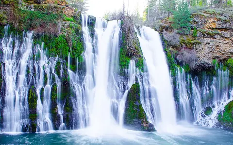
The falls lie in Shasta County within McArthur-Burney Falls Memorial State Park, near the meeting zone of the southern Cascade Range and the Modoc Plateau. Burney Creek drops 129 feet (39 metres) at the falls. The main stream passes over the brink, while numerous springs issue partway down the rock face, spreading the discharge across a much broader section of cliff.
129 ft / 39 m
A single main drop from the basalt-capped rim to the plunge basin.
Burney Creek
A short tributary flowing toward Lake Britton and the Pit River.
Volcanic aquifer
Rain and snowmelt stored in fractured lava sustain the springs.
Volcanic plateau and cliff structure
Successive lava flows built a layered volcanic surface around Burney Creek. Cooling cracks, gas-rich porous zones, and former lava tubes left pathways through the basalt. Water entering these openings can move beneath the plateau and collect above less permeable layers.
At the waterfall, durable basalt forms the caprock. Weaker volcanic tuff and breccia, together with soft sedimentary layers that include diatomite in the lower gorge, are more readily removed. Water erodes and undercuts these weaker beds, leaving the harder rim unsupported along its edge. This contrast between resistant caprock and erodible material below is fundamental to the falls' steep profile.
Springs and seasonal flow
The ultimate water source is rain and snow falling across the surrounding Pit River watershed. Some runoff travels at the surface, but a substantial share infiltrates the permeable volcanic rocks. In dry periods, Burney Creek can disappear into its bed upstream and return as seepage above the brink and as springs directly in the cliff.
This groundwater route stores water and releases it more gradually than surface runoff alone. As a result, the falls retain a large flow through the dry summer, even though storm runoff and snowmelt still affect the creek. Reported spring discharge at the falls is about 100 million US gallons per day, roughly 4.4 cubic metres per second. The unusual visual width of the falling water comes from both the creek at the crest and the many separate spring outlets below it.
Gorge development
Burney Creek once descended toward the Pit River through a sequence of rapids and cascades. Erosion worked upstream through softer deposits until it reached the more resistant basalt cap. Continued removal beneath that cap concentrated the drop into the present waterfall.
Below the plunge basin, the creek occupies a gorge about 1.25 miles (2 kilometres) long. The gorge records progressive downcutting and upstream retreat: falling water loosens weaker rock, blocks detach from the rim, and the channel carries smaller debris downstream. The waterfall is therefore one point within a connected erosional system rather than an isolated cliff.
Climate and regional drainage
The region has warm, generally dry summers and cold winters with rain and snow. Winter precipitation and mountain snowmelt recharge the volcanic groundwater system; subsurface storage then reduces the sharp summer decline typical of waterfalls supplied only by surface runoff. This buffering explains the contrast between the persistent falls and the seasonally dry appearance of parts of the surrounding plateau.
Below the falls, Burney Creek enters Lake Britton and then joins the Pit River system. The Pit flows west into Shasta Lake, from which water continues into the Sacramento River. Burney Falls thus occupies a small spring-fed branch of a much larger drainage connection between northeastern California's volcanic uplands and the Sacramento Valley.