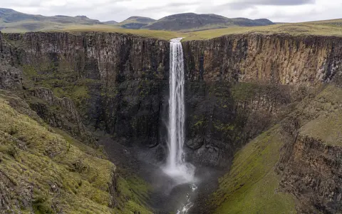
What Maletsunyane Falls is
Maletsunyane Falls lies near Semonkong in the central highlands of Lesotho. The river crosses an upland surface before reaching a sudden break in gradient, then drops into a narrow gorge cut below the surrounding plateau. The commonly reported vertical descent is 192 metres.
The landform is best understood as part of a longer river profile. A relatively open upstream valley becomes a rock threshold, cliff, plunge zone, and confined downstream channel over a short distance. This abrupt transition concentrates a modest highland river into a tall fall whose width and spray change with discharge.
Plateau edge, brink, and gorge
Above the falls, the Maletsunyane follows the gentler gradients of the high plateau. At the brink, the channel crosses a major fracture aligned roughly at right angles to the river. That structural weakness helps locate the sharp edge from which the water descends.
Below the lip, falling water, weathering, and rockfall act on the cliff and plunge zone, while the river carries loosened material through the gorge. The gorge records sustained incision below the plateau surface. Its steep walls and narrow floor keep the downstream channel confined until the valley gradually opens farther south.
Highland approach river
A lower-gradient channel crosses the basalt tableland near Semonkong.
Fractured rock brink
A cross-river fracture helps position the abrupt 192-metre drop.
Confined basalt gorge
Steep walls focus runoff and sediment into the incised lower channel.
Layered Jurassic lava flows
The highlands around Maletsunyane Falls are built from repeated basalt lava flows of the Drakensberg volcanic succession, emplaced during the Early Jurassic. The stacked flows produce a layered rock mass, while cooling joints, fractures, and differences between flow units create routes for weathering and erosion.
The waterfall's height comes from the large relief between the plateau and the gorge floor; the precise position of its brink is more closely tied to local rock structure. Water exploits cracks, removes weathered material, and undercuts exposed flow margins. Blocks can then detach along joints, allowing the cliff and gorge to evolve through episodic rockfall as well as continuous channel erosion.
Seasonal runoff from a high plateau
The Maletsunyane River gathers runoff from the high ground around and north of Semonkong. Its catchment is far smaller than those feeding broad trunk-river cataracts, so the waterfall responds visibly to rainfall over the surrounding plateau. Tributary inflow, soil moisture, shallow groundwater, and evaporation all affect the water reaching the brink.
Summer storms and sustained wet-season rain can produce a thicker fall, stronger spray, and greater turbulence below the cliff. During the dry, cold part of the year, discharge usually contracts and more of the rock face becomes exposed. Short runoff pulses can still follow individual storms, and the narrow gorge rapidly confines higher flows.
Summer rain and cold highland winters
Altitude is a major climate control at Maletsunyane Falls. Lesotho receives most of its precipitation between October and April, when convective storms and broader rain systems recharge highland streams. Rainfall varies substantially from year to year, so the strength of the wet-season flow is not uniform.
Winters are generally drier and cold, with frequent frost and occasional snow across the highlands. Low temperatures reduce evaporation but coincide with limited rainfall, so river flow commonly falls despite the cooler conditions. At the waterfall itself, the cliff and gorge create small contrasts in shade, exposure, wind, and spray moisture without changing the wider plateau climate.
From the Lesotho highlands to the Senqu
After leaving the gorge, the Maletsunyane continues south through deeply dissected highland terrain and joins the Senqu, known downstream as the Orange River. This places the falls inside the principal west-draining river network of Lesotho rather than the shorter river systems that descend eastward from the Great Escarpment.
Water and sediment exported from the falls therefore move into a much larger interior basin that crosses dry southern African landscapes before reaching the Atlantic Ocean. Maletsunyane Falls connects the waterfalls hub with the rivers hub, the Drakensberg record, and the terrain index.