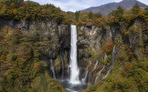
What Kegon Falls is
Kegon Falls lies at the eastern edge of Lake Chūzenji in Oku-Nikkō, the elevated mountain interior west of Nikkō city on central Honshū. The site is within Nikkō National Park in Tochigi Prefecture. The short outlet reach is locally known as the Ōjiri River and forms the head of the Daiya River system.
From the lake outlet, the channel crosses a narrow volcanic plateau before reaching the cliff. The main stream then falls about 97 metres into a confined gorge. Unlike a rainfall-fed fall on a small headwater creek, Kegon receives the outflow of a substantial lake, so its hydrology reflects water collected and stored across the Lake Chūzenji basin.
A sharp knickpoint below a mountain lake
The brink is a pronounced knickpoint—a sudden break in the downstream gradient—between the high lake-outlet surface and the lower Daiya valley. Water leaves the upper channel in a single main column, strikes projecting rock partway down under some flow conditions, and reaches a turbulent plunge zone at the foot of the cliff.
The gorge below records the long adjustment of the river to this step. Falling water, sediment impact, frost weathering, groundwater seepage, and rockfall all weaken the face. Block removal at the lip and within the cliff lets the waterfall retreat upstream over geological time, while the lower river carries fallen rock and finer debris away from the plunge zone.
Lake-outlet channel
Stored lake water enters a short surface channel on the high volcanic plateau.
Layered cliff
Andesite lava and weaker fragmental units create ledges, recesses, joints, and seepage lines.
Confined gorge
The Daiya River regathers below the fall and descends toward the lower Nikkō valley.
Mount Nantai lava and a dammed valley
Kegon Falls and Lake Chūzenji are products of the Nikkō volcanic landscape. Eruptions of nearby Mount Nantai around 20,000 years ago sent lava into an earlier river valley. The lava obstructed drainage and impounded water behind it, forming Lake Chūzenji. Overflow established an eastward outlet across the volcanic barrier, and incision at its outer edge produced the waterfall.
The cliff is not a single uniform rock mass. Its main sequence includes thick andesite lava units separated by weaker agglomerate—coarse volcanic debris—and local lake sediments. Cooling joints divide the massive lava into blocks, while the fragmental layers weather and erode more readily. This contrast helps maintain overhanging sections and recessed bands, but it also makes the face susceptible to rockfall. A major collapse at the brink in 1986 shifted part of the edge several metres upstream, showing that the present profile continues to change.
Surface outflow, groundwater, and managed discharge
Lake Chūzenji receives river inflow, direct precipitation, hillside runoff, snowmelt, and groundwater from the surrounding volcanic highlands. Because the lake stores this water before releasing it, it moderates short-lived fluctuations that would be sharper in a small stream basin. The visible main fall is the surface outlet, while part of the lake water also moves through joints and permeable contacts in the volcanic sequence.
Groundwater emerges from the cliff beside and behind the main column, producing numerous narrow side falls and wet bands. Their distribution follows fractures and boundaries between massive lava and more permeable or erodible deposits. This combination of concentrated surface flow and dispersed seepage makes the entire cliff part of the active hydrological system.
Outflow is also regulated at Chūzenji Dam near the lake outlet. The low control structure is operated for flood moderation, maintenance of river flow, and hydroelectric water supply, while retaining flow over Kegon Falls. Discharge at the brink therefore reflects both the lake's natural water balance and managed releases; it should not be read as a direct measure of rainfall on a single day.
A cool, wet highland water balance
Lake Chūzenji stands more than 1,200 metres above sea level, giving the falls a cooler climate than the nearby Kantō Plain. Moist warm-season air, frontal rain, and typhoons supply much of the basin's precipitation. Winter brings frost and snow, and spring melt adds water to the lake and its tributaries.
Lake storage spreads part of this seasonal input through time, while dam operations further shape the outlet hydrograph. At the cliff, repeated freezing and thawing can widen joints and loosen blocks. Ice may form on seepage-fed side falls and wet rock surfaces during cold periods, although the main regulated column can continue to flow.
From Oku-Nikkō to the Pacific drainage network
Kegon Falls occupies the boundary between two connected terrain levels. Upstream lies the broad lake basin, enclosed by Mount Nantai and other volcanic uplands. Downstream, the Daiya River loses elevation rapidly through a steep gorge and mountain valley before reaching lower ground around Nikkō.
The Daiya joins the Kinu River, which in turn belongs to the Tone River basin draining toward the Pacific Ocean. Kegon is therefore both a local cliff landform and a step in a much larger water-and-sediment route. Its most useful atlas connections are the waterfalls hub, the lakes hub, the rivers hub, and the terrain index.