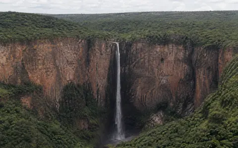
What Kalambo Falls is
Kalambo Falls lies near the southeastern corner of Lake Tanganyika, on the boundary between Zambia and Tanzania. The waterfall occupies an abrupt break between the higher plateau landscape and the deeply lowered floor of the Tanganyika Rift. Its commonly reported vertical drop is about 221 metres.
The river does not approach the brink as a large regional trunk stream. It drains a relatively compact upland catchment, crosses a sediment-floored basin above the falls, and then becomes confined as it reaches the escarpment. This contrast between a modest river and very large local relief gives the waterfall its narrow, high form.
Basin, spillway, brink, and gorge
Upstream, the Kalambo follows meandering channels across a basin containing river-laid and slope-derived sediment. Near the basin's downstream end, the channel enters a narrower bedrock spillway before reaching the main brink. The water then drops into a steep gorge cut into the rift escarpment.
These linked landforms show a sharp downstream change in river energy. In the upper basin, lateral channel movement and overbank deposition spread water and sediment across a broader valley floor. At the constriction and falls, flow accelerates, and erosion is concentrated along the rock lip, cliff face, plunge zone, and confined lower channel.
Meandering basin reach
Channel and floodplain deposits record repeated lateral movement and sediment accumulation.
Bedrock spillway and brink
A narrow approach focuses the river before its steep single drop.
Rift-margin gorge
The river descends through confined relief toward the Lake Tanganyika lowland.
Rift relief and resistant rock
Kalambo Falls stands on the southern Tanganyika Rift, part of the western branch of the East African Rift system. Regional faulting lowered and opened the Tanganyika basin while leaving steep escarpments between the lake trough and adjacent uplands. Research on the southern rift margin indicates that river diversion and capture established a shorter route to Lake Tanganyika, producing the large gradient break now occupied by the falls.
The local rock succession includes sandstone, quartzite, shale, and igneous intrusions such as dolerite. Differences in resistance, together with joints and other weaknesses, influence the brink and gorge. Falling water, spray, transported sediment, and weathering work on those surfaces, while the regional relief ultimately comes from the tectonic architecture of the rift margin.
Seasonal flow through a small catchment
The Kalambo rises in the Ufipa uplands of southwestern Tanzania and flows generally southward and westward toward the falls. Tributaries and seasonal channels add runoff within the upper basin. Because the catchment is much smaller than those of broad river waterfalls, the width and volume of the falling water respond clearly to recent rainfall across the uplands.
During the wet season, rising discharge produces a fuller descent and stronger turbulence at the foot of the cliff. Through the dry season, reduced runoff narrows the active flow. The bedrock threshold remains fixed on a human timescale, but the visible waterfall changes as water depth, velocity, and spray production vary.
Wet and dry seasons on the rift uplands
Rainfall over the Kalambo catchment is strongly seasonal. A warm wet season supplies most river recharge and activates smaller tributaries, while a prolonged dry season reduces direct runoff. The upper basin stores and releases some water through its channel, floodplain sediments, soils, and shallow groundwater, moderating but not removing the seasonal signal.
Elevation and relief create local contrasts. The plateau is cooler than the low rift floor, and the escarpment forces rapid changes in exposure and drainage. At the falls, persistent spray during stronger flow moistens the cliff and gorge immediately beside the active channel, but this narrow spray zone should not be confused with the climate of the wider catchment.
From upland river to Lake Tanganyika
Below the falls, the Kalambo continues through its gorge and reaches Lake Tanganyika only a short distance downstream. Sediment delivered by the river enters the lake at the base of the escarpment, linking erosion in the Ufipa uplands to deposition along the edge of a deep freshwater rift basin.
This downstream connection places Kalambo Falls within the wider Tanganyika drainage system. Lake water ultimately leaves through the Lukuga River and joins the Lualaba–Congo network. The falls therefore connect the waterfalls hub with the Lake Tanganyika record, the rivers hub, and the terrain index.