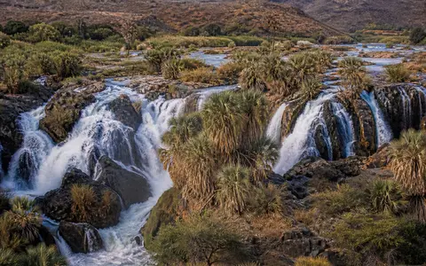
What Epupa Falls is
Epupa Falls lies in northwestern Namibia and southwestern Angola, where the Kunene forms the international boundary. In Angola the waterfall is also known as Monte Negro Falls. The name refers not to one uniform curtain of water but to a complex descent made of rapids, cascades, side channels, and several larger drops.
The broken waterfall reach extends for approximately 1.5 kilometres. Widely repeated descriptions assign about 60 metres of cumulative descent to the complex and roughly 37 metres to its largest individual fall, while inventories that map a narrower central feature give lower values. The figures are therefore best treated as approximate measures of differently defined parts of the landform, not as interchangeable dimensions.
Ancient gneiss and divided channels
The falls cross the Epupa Metamorphic Complex, an old basement terrane dominated by granitoid gneisses and related metamorphic rocks. Much of this crust formed during the Palaeoproterozoic, roughly 1.75 to 1.8 billion years ago, and was later deformed and metamorphosed. Its resistant but fractured rock provides the uneven foundation of the cascade reach.
Faults, joints, and contrasts within the bedrock help steer the Kunene. Where flow meets exposed rock ribs and islands, it separates into multiple channels; where those channels encounter abrupt changes in bed elevation, they form chutes and falls. The resulting plan is more complex than a single retreating waterfall lip, because erosion is distributed among many parallel and reconnecting routes.
Broad river reach
Perennial flow arrives across a bedrock channel near the edge of the dry Kaokoveld uplands.
Islands, ribs, and chutes
Exposed rock divides the river and concentrates water into separate descending channels.
Rejoining flow
Channels recombine below successive drops as the river continues into more confined terrain.
Angolan headwaters and seasonal pulses
The Kunene rises in the relatively wet highlands of central Angola and drains a basin of about 106,500 square kilometres, most of it north of the Namibian border. This remote water supply makes the river perennial at Epupa even though rainfall beside the falls is too low and unreliable to support comparable flow on its own.
Discharge still changes strongly through the year. Summer rainfall across the upper and middle basin produces higher flows that spread through more side channels and cover additional bedrock. During lower-flow periods, islands, ledges, and individual chutes become more distinct. Upstream reservoirs, water transfers, and hydropower operations also modify the timing and short-term pattern of flow, but basin rainfall remains the fundamental source.
A river corridor in dry border terrain
Epupa has a hot, dry climate with highly variable summer rainfall. Average annual totals are generally around 100 to 200 millimetres, while evaporation is high and droughts are frequent. Rainfall decreases markedly westward toward the Namib and Atlantic coast, so the regional landscape becomes progressively more arid downstream.
The contrast between catchment and site is the main climate control on the falls. Moisture gathered far upstream crosses a rocky landscape of sparse local runoff. Flood pulses therefore record rainfall over distant parts of Angola as well as nearer tributaries, while the exposed channels, shallow soils, and steep banks around the falls reflect long-term water scarcity outside the river corridor.
From interior highlands to the Atlantic
Epupa Falls belongs to the middle-to-lower Kunene system. Upstream, the river descends from Angola's central plateau through a sequence of regulated reaches and cataracts. At Epupa it crosses a pronounced local gradient break, then continues west through increasingly rugged and arid country.
Farther downstream, the Kunene becomes confined among the northern Kaokoveld and Baynes Mountain landscapes before crossing the Namib Desert margin and reaching the Atlantic Ocean. Epupa therefore connects the waterfalls hub with the rivers hub and the terrain index, illustrating how structure and relief can divide a large river into many falls without breaking its basin-scale route to the sea.