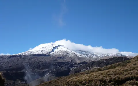

What Nevado del Ruiz is
Nevado del Ruiz stands on the boundary between the departments of Caldas and Tolima, about 28 kilometres southeast of Manizales. It occupies the crest of Colombia's Cordillera Central, between the Cauca depression to the west and the Magdalena valley to the east.
The volcano covers more than 200 square kilometres and is broader than a simple steep-sided cone. Repeated construction and destruction of volcanic edifices have left an overlapping complex of lava flows, domes, pyroclastic deposits, collapse deposits, and younger channels cut by ice and running water.
A wide edifice with a cratered summit
Ruiz rises from dissected Andean uplands into a comparatively broad summit area. Long ridges descend from the ice cap, separated by ravines that deepen into river valleys on the lower flanks. This radial pattern exposes the contrast between constructional lava surfaces and erosion along drainage lines.
Arenas crater occupies the active summit zone. It is roughly one kilometre across, with steep inner walls and a floor altered by heat, gas, and recent volcanic deposits. La Olleta, a prominent pyroclastic cone on the southwest flank, is part of the wider volcanic complex rather than the main summit.
Arenas crater
The active crater breaks the high, ice-covered surface of the volcano.
Ridges and ravines
Radial valleys cut through lava, ash, and older debris-flow deposits.
Broad volcanic complex
Several generations of volcanic terrain extend beyond the modern summit cone.
Composite terrain on a continental arc
The Nevado del Ruiz volcanic complex records several major stages of growth, collapse, and rebuilding extending back into the Pleistocene. The present edifice began developing within the remains of older volcanic terrain. Andesitic and dacitic lava flows and domes alternate with ash, pumice, pyroclastic-flow deposits, debris avalanches, and lahars.
Ruiz belongs to the Northern Volcanic Zone of the Andes. Its magma is associated with the eastward subduction of the oceanic Nazca Plate beneath the South American Plate. Regional faults also cross the Central Cordillera and help define the structural setting in which the volcanic complex developed.
A shrinking ice cap above mobile sediment
Although Ruiz lies less than five degrees north of the equator, its elevation keeps the summit cold enough for permanent ice. The glacier is now divided across the upper slopes and has retreated substantially from its former extent. Ice persists because temperature falls with altitude, while its size responds to snowfall, air temperature, dark ash on the surface, and heat from volcanic activity.
Water released from snow and ice can mix with ash, loose rock, and older deposits to form lahars. Steep headwater channels funnel these flows into established valleys, allowing them to travel far from the summit. The 1985 eruption demonstrated this terrain connection when lahars descended several drainage systems, including the Lagunilla valley; the enduring geographic lesson is that valley form governs the reach of volcanic sediment and meltwater.
Headwaters divided between two great basins
Streams radiate from the summit and descend toward both sides of the Cordillera Central. On the eastern and northern flanks, the Lagunilla, Recio, Gualí, and Azufrado systems carry water and sediment toward the Magdalena basin. Their upper valleys cut directly into volcanic and glacial deposits.
Western and southwestern drainage, including the Claro and Chinchiná systems, ultimately reaches the Cauca basin. Ruiz therefore stands close to a major inter-basin divide: water leaving neighboring sectors of the same ice cap can follow different regional routes before the Cauca and Magdalena systems eventually join farther north.
Tropical moisture shaped by extreme elevation
Latitude keeps seasonal temperature contrasts modest at lower elevations, but the climb from intermontane valleys to the summit produces strong vertical climate zones. Moist air rising over the Central Cordillera cools and condenses, bringing frequent cloud and precipitation to the high slopes; at the summit, much of that precipitation can fall as snow or graupel.
Exposure differs around the massif as winds and valley circulations direct moisture toward particular slopes. Below the ice, runoff crosses cold high-elevation terrain and then descends rapidly through wetter Andean belts. Volcanic ash can temporarily darken snow and ice, increasing absorption of solar energy and accelerating surface melt.
The northern end of the Ruiz–Tolima chain
Nevado del Ruiz is part of a north–south volcanic alignment along the high Cordillera Central. Nevado de Santa Isabel and Nevado del Tolima lie farther south, while Cerro Bravo lies to the north. Together these centers form a volcanic landscape built on older metamorphic and intrusive rocks and reshaped by glaciers, rivers, mass movement, and repeated eruptions.
The mountain connects the crest of the Andes to the Cauca and Magdalena drainage systems and to populated intermontane valleys on either side. Within the volcanoes hub, Ruiz is a clear example of how composite-volcano construction, tropical summit ice, radial hydrology, and lahar corridors operate as parts of one physical system.