.jpg)
What Mount Ruapehu is
Mount Ruapehu occupies the southern part of the central North Island volcanic landscape, southwest of Mount Ngauruhoe and the wider Tongariro volcanic complex. The massif rises well above the surrounding plateau, with broad lower flanks extending into forested valleys and open uplands.
Ruapehu is not a single, geometrically even cone. Repeated eruptions from changing vents have built overlapping sectors of lava and volcanic debris, while collapse, glaciers, streams, and lahars have cut into that construction. The result is a wide, irregular massif capped by multiple peaks rather than one simple summit point.
A broad cone with a broken summit
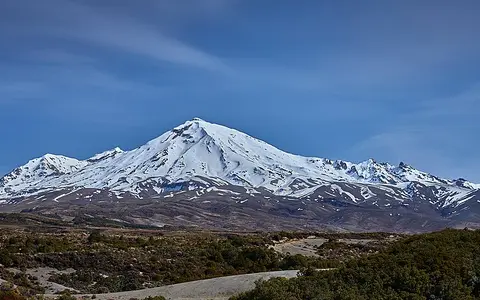
From the volcanic plateau, Ruapehu's slopes climb through long ridges and deeply incised radial valleys to a high summit zone. Tahurangi reaches 2,797 metres, while other prominent high points, including Te Heuheu and Paretetaitonga, help form the serrated rim around the upper basin.
Rock ribs separate snowfields and small glaciers on the upper mountain. Lower down, ridges broaden between valleys cut into lava flows, ash, and older debris-flow deposits. This alternation of constructional volcanic slopes and erosional channels gives each side of the massif a different profile.
Wide volcanic apron
Lava and fragmental deposits spread outward across the central plateau.
Ridges and ice-cut valleys
Glaciers and runoff have dissected the steep cone into radial terrain.
Several high peaks
A broken rim surrounds the upper crater and snow basin.
An andesite cone above a subduction margin
Ruapehu is composed mainly of andesite lava flows, breccias, ash, and other deposits accumulated over many eruptive episodes. Successive vents have shifted within the summit area, so younger materials overlap and partly conceal older cone sectors.
The volcano lies near the southern end of the Taupō Volcanic Zone. Magma generation is tied to subduction east of the North Island, where the Pacific Plate descends beneath the Australian Plate. Ruapehu's cone is therefore part of a regional volcanic system that continues northward through the central plateau, although its tall composite form differs from the zone's broad calderas.
An active vent within a summit basin
Crater Lake, also known as Te Wai ā-moe, occupies the active summit crater between Ruapehu's main peaks. Snow, ice melt, precipitation, geothermal heat, volcanic gases, and eruptive material all influence the lake, making it part of both the mountain's drainage system and its active vent.
The lake drains from its eastern side into the headwaters of the Whangaehu River. Eruptions or failure of material retaining the lake can release water and volcanic sediment into this valley as lahars. Older lahar deposits on several flanks show that fast-moving mixtures of water and debris are a recurring landform process, not only a feature of the present channel.
Glaciers and radial headwaters
Ruapehu carries the North Island's largest concentration of permanent ice. Small glaciers and snowfields occupy the upper flanks, especially in shaded or sheltered hollows. They have carved cirques and troughs, sharpened ridges, and supplied sediment and meltwater to the valleys below.
Drainage radiates away from the summit divide. The Whangaehu runs southeast from Crater Lake toward the coast, while western and northwestern streams feed the Whanganui River system. Water from the northern and eastern slopes also enters tributaries leading toward the Tongariro River and Lake Taupō basin. Volcanic deposits make many channels sediment-rich and provide loose material that floods and lahars can remobilize.
Westerly moisture and elevation
Prevailing westerly winds bring moist air from the Tasman Sea toward Ruapehu. As that air rises over the massif it cools, producing frequent cloud, rain, and heavy winter snow on the high slopes. Temperature falls strongly with elevation, allowing snowfields and glaciers to persist despite the mountain's temperate latitude.
The western side generally receives more moisture, while descending air creates a relative rain shadow to the east. Exposure also matters: strong winds scour ridges, move snow into sheltered basins, and create rapid changes in surface conditions. Seasonal snow expands far below the permanent ice before retreating during warmer months.
The high point of the central volcanic plateau
Ruapehu forms the southern and highest part of a north–south volcanic alignment that includes Ngauruhoe and Tongariro. Together these mountains stand above the North Island Volcanic Plateau and mark the transition from the active Taupō Volcanic Zone to older uplands farther south.
The massif is also a regional water divide. Its valleys connect the summit to the Whanganui catchment in the west, the Whangaehu basin in the southeast, and the Lake Taupō drainage system to the north and east. Within the volcanoes hub, Ruapehu demonstrates how volcanic construction, glacial erosion, crater-lake hydrology, and plate-margin processes combine in one high-relief landform.