
What Mount Erebus is
Mount Erebus is the largest of the principal volcanoes that build roughly triangular Ross Island. It stands at about 77.5° south, offshore from the Scott Coast of Victoria Land, with Mount Terror to the east and the lower Hut Point Peninsula extending south toward McMurdo Sound.
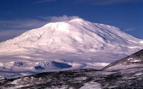
The mountain is a composite, or stratovolcano, but its profile differs from a simple cone. Older lava-built flanks support a broad summit plateau at about 3,200 metres, marking the rim of the youngest caldera. A modern cone rises inside that structure to the active summit crater.
Island-scale volcanic relief
Erebus rises from near sea level to 3,794 metres over a relatively short horizontal distance. Broad lower slopes narrow toward the caldera platform and summit cone, producing strong relief above McMurdo Sound, the Ross Sea, and the ice-covered margins of Ross Island.
Lava flows, scoria cones, domes, ridges, and eroded remnants break the otherwise sweeping flank profile. Fang Ridge on the northeastern flank preserves part of an older volcanic structure, while younger materials partly bury earlier surfaces. Snow and glacier ice cover much of the mountain, but dark rock and ash remain exposed on steep, wind-scoured, or geothermally warmed ground.
Broad lava-built slopes
Overlapping flows and volcanic deposits form the main island massif.
Caldera platform
A high bench records collapse and later infilling before the modern cone grew.
Nested crater terrain
The main crater encloses a deeper inner crater and active lava lake.
A phonolite volcano in a rift setting
Erebus belongs to the McMurdo Volcanic Province, a belt of alkaline volcanism associated with extended crust along the western Ross Sea. Unlike volcanoes built above a subduction zone, Erebus is an intraplate volcano in the broader West Antarctic Rift System, where crustal extension provides routes for magma to rise.
Much of the upper volcano is built from phonolite, a silica-undersaturated alkaline volcanic rock. Its summit system is fed by carbon-dioxide-rich magma rising from depth through a plumbing system shaped by the rifted crust. The result is long-lived low-level activity punctuated by small explosions rather than continuous large outpourings across the flanks.
Caldera, inner crater, and lava lake
The summit is truncated by an elliptical main crater about 500 by 600 metres across and roughly 110 metres deep. Within it, a smaller inner crater descends toward the active phonolite lava lake. The lake has been documented since 1972 and represents exposed magma circulating at the surface.
Gas release and intermittent Strombolian explosions can eject molten bombs onto the crater floor and rim. These processes continually rework a small area at the summit, while the much larger form of Erebus records repeated construction, collapse, and renewed cone growth over a far longer timescale.
Glaciated slopes with limited runoff
Glacier ice and permanent snow mantle large areas of Erebus, filling shallow depressions and flowing downslope toward the coastal margins of Ross Island. Ice lies beside lava flows, ash, and warm volcanic ground, making the mountain's surface a patchwork of frozen and volcanic terrain.
There is no extensive river network. The polar cold locks most precipitation into snow and ice, so drainage is dominated by glacier movement, local meltwater, and short seasonal channels near exposed ground. Steam and volcanic gases warm parts of the summit and upper flanks, producing fumarolic ice towers and caves locally, but this geothermal melting does not replace the island's overall glacial character.
Polar cold, elevation, and wind
Erebus lies in a cold polar desert. Its high elevation lowers temperatures further than at the coast, while strong winds redistribute snow and expose rock on ridges. Moisture reaching Ross Island is limited, and much of what falls remains frozen rather than feeding liquid runoff.
Topography creates sharp local contrasts. Snow accumulates in sheltered hollows and on glacier surfaces, whereas wind-scoured slopes may stay bare. Near fumaroles, heat and water vapour create small warm-ground zones and ice features within an otherwise persistently frozen landscape.
Ross Island and the Antarctic margin
Mount Erebus anchors the western side of Ross Island between the open Ross Sea sector, seasonally ice-covered McMurdo Sound, and the margin of the Ross Ice Shelf. Across McMurdo Sound, the Transantarctic Mountains rise along the edge of East Antarctica, placing the volcano opposite a major continental mountain and ice-sheet boundary.
Its position links several scales of physical geography: a summit lava lake, an ice-covered volcanic massif, an island assembled from several volcanoes, and a rift system extending beneath the Ross Embayment. Within the volcanoes hub, Erebus is therefore a clear example of how volcanic terrain can develop in a high-latitude continental-rift environment.